Sharnbrook elevation
Sharnbrook (England, Bedford), United Kingdom elevation is 56 meters and Sharnbrook elevation in feet is 184 ft above sea level [src 1]. Sharnbrook is a seat of a third-order administrative division (feature code) with elevation that is 16 meters (52 ft) smaller than average city elevation in United Kingdom.
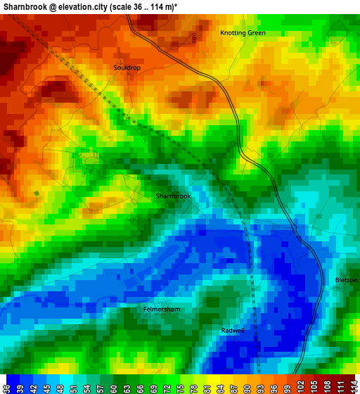
Below is the Elevation map of Sharnbrook, which displays elevation range with different colors. Scale of the first map is from 36 to 114 m (118 to 374 ft) with average elevation of 69.3 meters (=227 ft) [note 1]
These maps also provides idea of topography and contour of this city, they are displayed at different zoom levels. More info about maps, scale and edge coordinates you can find below images.
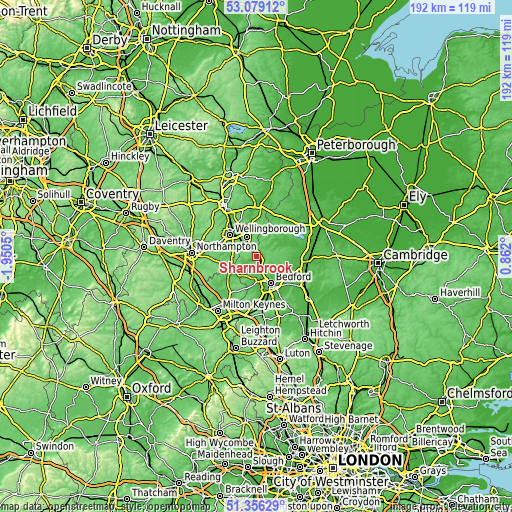
| \ | Map #1 | Topo.Map |
| Scale [m] | 36..114 m | × |
| Scale [ft] | 118..374 ft | × |
| Average | 69.3 m = 227 ft | × |
| Width | 5.99 km = 3.7 mi | 191.6 km = 119.1 mi |
| Height | 5.99 km = 3.7 mi | 191.5 km = 119 mi |
| ↑Max Latitude | 52.25297° | 53.07912° |
| Latitude at center | 52.22606° | 52.22606° |
| ↓Min Latitude | 52.199133° | 51.35629° |
| ← Min Longitude | -0.588195° | -1.9505° |
| Longitude center | -0.54425° | -0.54425° |
| →Max Longitude | -0.500305° | 0.862° |
Nearby cities:
Cities around Sharnbrook sort by population:
• Rushden elevation 61 m
8 km,  330°
330°
• Bromham 38 m
9.1 km,  173°
173°
• Clapham 33 m
8 km,  155°
155°
• Irchester 77 m
9.2 km,  311°
311°
• Oakley 43 m
6.5 km, 169°
• Bozeat 84 m
8.8 km,  267°
267°
• Harrold 48 m
5.3 km,  238°
238°
• Riseley 58 m
5.3 km,  56°
56°
• Stevington 49 m
6.4 km,  186°
186°
• Podington 75 m
6.3 km,  299°
299°
• Swineshead 51 m
8.8 km,  46°
46°
• Odell 48 m
3.6 km, 238°
Multilingual:
 En español:
Sharnbrook elevación 56 m.
 En France:
Sharnbrook élévation 56 m.
 Auf Deutsch:
Sharnbrook höhe über dem Meeresspiegel ist 56 m.

Sources and notes:
- [note 1] Map square and city borders are not equal. Map elevation data is calculated only from area inside that square.
- [src 1] Elevation data from geonames database provided with same terms of usage.
- [src 2] The elevation map of Sharnbrook is generated using elevation data from NASA's 3 arcsec (90m) resolution SRTM data.
- [src 3] Base (background) map © OpenStreetMap contributors tiles are generated by Geofabrik and OpenTopoMap.
Copyright & License:
This Sharnbrook Elevation Map is licensed under CC BY-SA. You may reuse any part from this page, if you give a proper credit by linking to this URL:
 More info on terms of use page.