Southam elevation
Southam (England, Warwickshire), United Kingdom elevation is 87 meters and Southam elevation in feet is 285 ft above sea level [src 1]. Southam is a populated place (feature code) with elevation that is 15 meters (49 ft) bigger than average city elevation in United Kingdom.
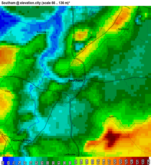
Below is the Elevation map of Southam, which displays elevation range with different colors. Scale of the first map is from 66 to 136 m (217 to 446 ft) with average elevation of 91.7 meters (=301 ft) [note 1]
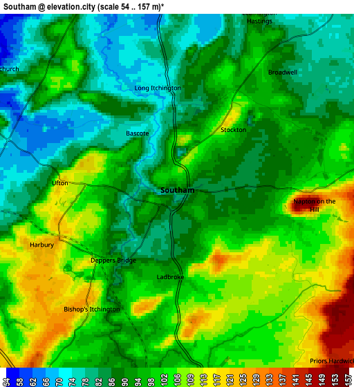
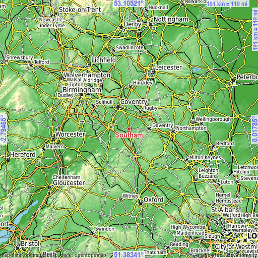
These maps also provides idea of topography and contour of this city, they are displayed at different zoom levels. More info about maps, scale and edge coordinates you can find below images.
| \ | Map #1 | Map #2 | Topo.Map |
| Scale [m] | 66..136 m | 54..157 m | × |
| Scale [ft] | 217..446 ft | 177..515 ft | × |
| Average | 91.7 m = 301 ft | 95.3 m = 313 ft | × |
| Width | 5.98 km = 3.7 mi | 11.97 km = 7.4 mi | 191.4 km = 118.9 mi |
| Height | 5.98 km = 3.7 mi | 11.97 km = 7.4 mi | 191.4 km = 118.9 mi |
| ↑Max Latitude | 52.279554° | 52.306432° | 53.10521° |
| Latitude at center | 52.25266° | 52.25266° | 52.25266° |
| ↓Min Latitude | 52.225749° | 52.198822° | 51.38341° |
| ← Min Longitude | -1.432345° | -1.476291° | -2.79465° |
| Longitude center | -1.3884° | -1.3884° | -1.3884° |
| →Max Longitude | -1.344455° | -1.300509° | 0.01785° |
Nearby cities:
Cities around Southam sort by population:
• Royal Leamington Spa elevation 74 m
9.7 km,  292°
292°
• Warwick 57 m
13.7 km,  284°
284°
• Claydon 137 m
12.2 km,  161°
161°
• Dunchurch 122 m
11.5 km,  34°
34°
• Farnborough 155 m
12.3 km,  173°
173°
• Harbury 126 m
5.1 km,  247°
247°
• Kineton 91 m
13.6 km,  218°
218°
• Ryton on Dunsmore 80 m
13 km,  346°
346°
• Long Itchington 75 m
3.5 km,  355°
355°
• Braunston 110 m
13.3 km,  71°
71°
• Stockton 102 m
2.9 km,  41°
41°
• Byfield 156 m
13 km,  131°
131°
Multilingual:
 En español:
Southam elevación 87 m.
 En France:
Southam élévation 87 m.


Sources and notes:
- [note 1] Map square and city borders are not equal. Map elevation data is calculated only from area inside that square.
- [src 1] Elevation data from geonames database provided with same terms of usage.
- [src 2] The elevation map of Southam is generated using elevation data from NASA's 3 arcsec (90m) resolution SRTM data.
- [src 3] Base (background) map © OpenStreetMap contributors tiles are generated by Geofabrik and OpenTopoMap.
Copyright & License:
This Southam Elevation Map is licensed under CC BY-SA. You may reuse any part from this page, if you give a proper credit by linking to this URL:
 More info on terms of use page.