Stewkley elevation
Stewkley (England, Buckinghamshire), United Kingdom elevation is 149 meters and Stewkley elevation in feet is 489 ft above sea level [src 1]. Stewkley is a populated place (feature code) with elevation that is 77 meters (253 ft) bigger than average city elevation in United Kingdom.
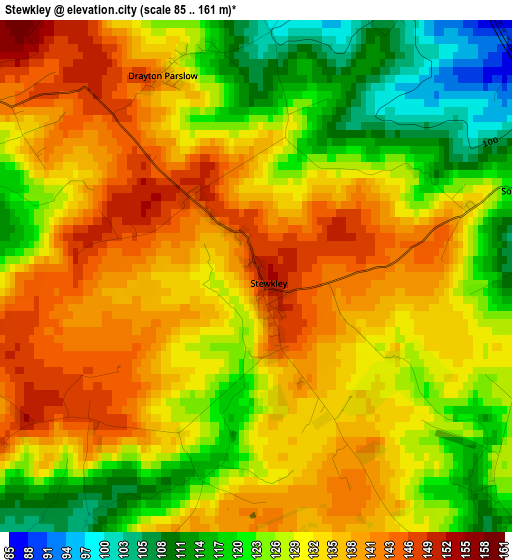
Below is the Elevation map of Stewkley, which displays elevation range with different colors. Scale of the first map is from 85 to 161 m (279 to 528 ft) with average elevation of 130.3 meters (=427 ft) [note 1]
These maps also provides idea of topography and contour of this city, they are displayed at different zoom levels. More info about maps, scale and edge coordinates you can find below images.
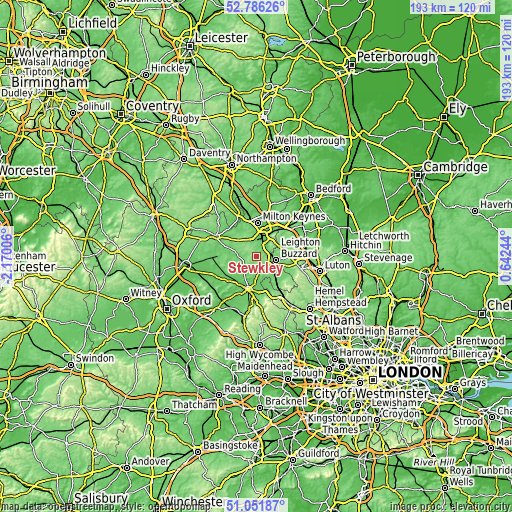
| \ | Map #1 | Topo.Map |
| Scale [m] | 85..161 m | × |
| Scale [ft] | 279..528 ft | × |
| Average | 130.3 m = 427 ft | × |
| Width | 6.03 km = 3.7 mi | 192.8 km = 119.8 mi |
| Height | 6.03 km = 3.7 mi | 192.8 km = 119.8 mi |
| ↑Max Latitude | 51.954531° | 52.78626° |
| Latitude at center | 51.92744° | 51.92744° |
| ↓Min Latitude | 51.900333° | 51.05187° |
| ← Min Longitude | -0.807755° | -2.17006° |
| Longitude center | -0.76381° | -0.76381° |
| →Max Longitude | -0.719865° | 0.64244° |
Nearby cities:
Cities around Stewkley sort by population:
• Bletchley elevation 82 m
7.6 km,  15°
15°
• Leighton Buzzard 97 m
7.3 km,  98°
98°
• Water Eaton 83 m
7.2 km, 23°
• Winslow 119 m
8.2 km,  282°
282°
• Wing 125 m
4.7 km,  139°
139°
• Newton Longville 107 m
5.4 km,  358°
358°
• Wingrave 131 m
7.1 km,  168°
168°
• Heath and Reach 107 m
7.6 km,  74°
74°
• Great Horwood 124 m
9.5 km,  302°
302°
• Bow Brickhill 102 m
10.1 km,  34°
34°
• Simpson 77 m
10.8 km, 23°
• Potsgrove 150 m
10.6 km, 70°
Multilingual:
 En español:
Stewkley elevación 149 m.
 En France:
Stewkley élévation 149 m.
 Auf Deutsch:
Stewkley höhe über dem Meeresspiegel ist 149 m.

Sources and notes:
- [note 1] Map square and city borders are not equal. Map elevation data is calculated only from area inside that square.
- [src 1] Elevation data from geonames database provided with same terms of usage.
- [src 2] The elevation map of Stewkley is generated using elevation data from NASA's 3 arcsec (90m) resolution SRTM data.
- [src 3] Base (background) map © OpenStreetMap contributors tiles are generated by Geofabrik and OpenTopoMap.
Copyright & License:
This Stewkley Elevation Map is licensed under CC BY-SA. You may reuse any part from this page, if you give a proper credit by linking to this URL:
 More info on terms of use page.