Stoke-on-Trent elevation
Stoke-on-Trent (England), United Kingdom elevation is 114 meters and Stoke-on-Trent elevation in feet is 374 ft above sea level [src 1]. Stoke-on-Trent is a seat of a second-order administrative division (feature code) with elevation that is 42 meters (138 ft) bigger than average city elevation in United Kingdom.
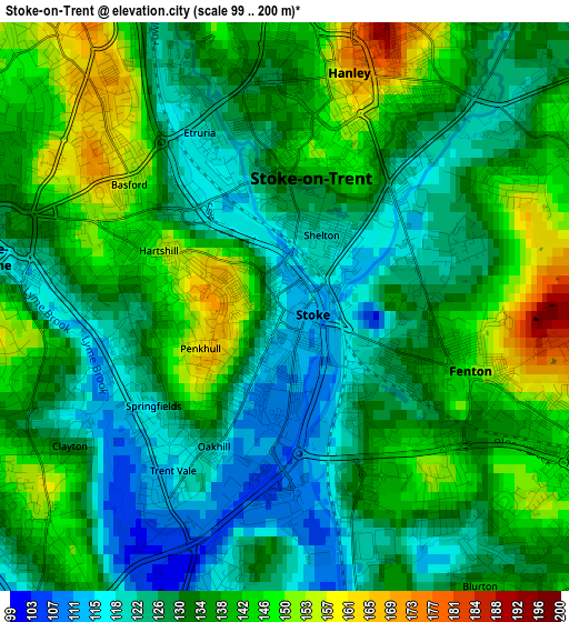
Below is the Elevation map of Stoke-on-Trent, which displays elevation range with different colors. Scale of the first map is from 99 to 200 m (325 to 656 ft) with average elevation of 133.7 meters (=439 ft) [note 1]
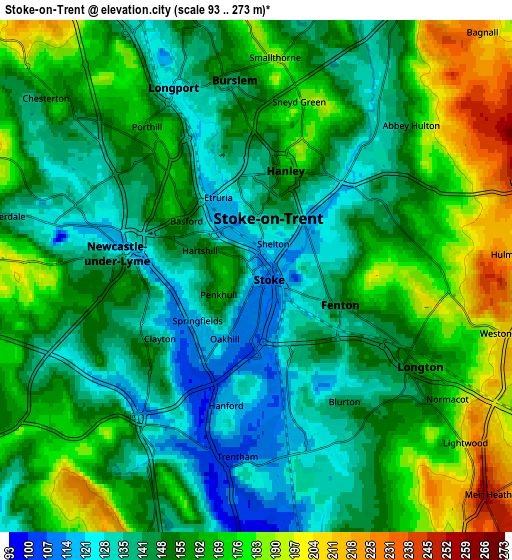
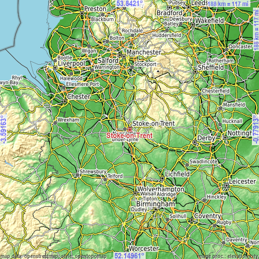
These maps also provides idea of topography and contour of this city, they are displayed at different zoom levels. More info about maps, scale and edge coordinates you can find below images.
| \ | Map #1 | Map #2 | Topo.Map |
| Scale [m] | 99..200 m | 93..273 m | × |
| Scale [ft] | 325..656 ft | 305..896 ft | × |
| Average | 133.7 m = 439 ft | 155.9 m = 511 ft | × |
| Width | 5.88 km = 3.7 mi | 11.76 km = 7.3 mi | 188.2 km = 116.9 mi |
| Height | 5.88 km = 3.7 mi | 11.76 km = 7.3 mi | 188.2 km = 116.9 mi |
| ↑Max Latitude | 53.030586° | 53.057006° | 53.8421° |
| Latitude at center | 53.00415° | 53.00415° | 53.00415° |
| ↓Min Latitude | 52.977697° | 52.951229° | 52.14961° |
| ← Min Longitude | -2.229325° | -2.273271° | -3.59163° |
| Longitude center | -2.18538° | -2.18538° | -2.18538° |
| →Max Longitude | -2.141435° | -2.097489° | -0.77913° |
Nearby cities:
Cities around Stoke-on-Trent sort by population:
• Newcastle under Lyme elevation 160 m
3.2 km,  261°
261°
• Kidsgrove 148 m
9.8 km,  339°
339°
• Biddulph 173 m
12.6 km,  2°
2°
• Stone 94 m
11.1 km,  169°
169°
• Longton 150 m
4.2 km,  123°
123°
• Tunstall 152 m
6.3 km, 343°
• Audley 143 m
9.2 km,  303°
303°
• Keele 183 m
6.8 km,  269°
269°
• Madeley 109 m
9.9 km, 267°
• Standon 129 m
11.7 km,  213°
213°
• Cheddleton 162 m
12 km,  52°
52°
• Barlaston 106 m
7 km, 171°
Multilingual:
 En español:
Stoke-on-Trent elevación 114 m.
 En France:
Stoke-on-Trent élévation 114 m.
 Auf Deutsch:
Stoke-on-Trent höhe über dem Meeresspiegel ist 114 m.

Sources and notes:
- [note 1] Map square and city borders are not equal. Map elevation data is calculated only from area inside that square.
- [src 1] Elevation data from geonames database provided with same terms of usage.
- [src 2] The elevation map of Stoke-on-Trent is generated using elevation data from NASA's 3 arcsec (90m) resolution SRTM data.
- [src 3] Base (background) map © OpenStreetMap contributors tiles are generated by Geofabrik and OpenTopoMap.
Copyright & License:
This Stoke-on-Trent Elevation Map is licensed under CC BY-SA. You may reuse any part from this page, if you give a proper credit by linking to this URL:
 More info on terms of use page.