Swinton elevation
Swinton (England, Manchester), United Kingdom elevation is 46 meters and Swinton elevation in feet is 151 ft above sea level [src 1]. Swinton is a populated place (feature code) with elevation that is 26 meters (85 ft) smaller than average city elevation in United Kingdom.
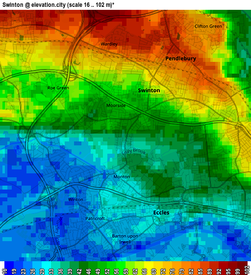
Below is the Elevation map of Swinton, which displays elevation range with different colors. Scale of the first map is from 16 to 102 m (52 to 335 ft) with average elevation of 49.3 meters (=162 ft) [note 1]
These maps also provides idea of topography and contour of this city, they are displayed at different zoom levels. More info about maps, scale and edge coordinates you can find below images.
| \ | Map #1 | Map #2 | Topo.Map |
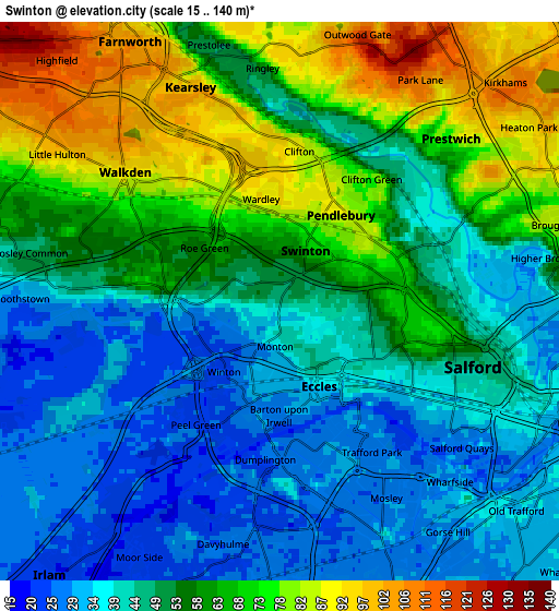
| Scale [m] | 16..102 m | 15..140 m | × |
| Scale [ft] | 52..335 ft | 49..459 ft | × |
| Average | 49.3 m = 162 ft | 53.9 m = 177 ft | × |
| Width | 5.81 km = 3.6 mi | 11.63 km = 7.2 mi | 186 km = 115.6 mi |
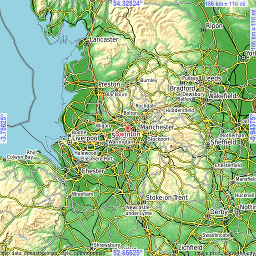
| Height | 5.81 km = 3.6 mi | 11.63 km = 7.2 mi | 186 km = 115.6 mi |
| ↑Max Latitude | 53.526132° | 53.552247° | 54.32824° |
| Latitude at center | 53.5° | 53.5° | 53.5° |
| ↓Min Latitude | 53.473852° | 53.447688° | 52.65525° |
| ← Min Longitude | -2.393945° | -2.437891° | -3.75625° |
| Longitude center | -2.35° | -2.35° | -2.35° |
| →Max Longitude | -2.306055° | -2.262109° | -0.94375° |
Nearby cities:
Cities around Swinton sort by population:
• Salford elevation 44 m
4.2 km,  109°
109°
• Stretford 27 m
6 km,  158°
158°
• Urmston 26 m
5.7 km,  182°
182°
• Eccles 32 m
2.2 km,  149°
149°
• Walkden 68 m
3.8 km,  299°
299°
• Radcliffe 76 m
7.1 km,  13°
13°
• Prestwich 97 m
5.8 km,  49°
49°
• Farnworth 102 m
6.5 km,  329°
329°
• Whitefield 124 m
6.5 km,  30°
30°
• Little Hulton 112 m
5.8 km,  310°
310°
• Kearsley 100 m
4.3 km, 329°
• Trafford Park 28 m
4.3 km,  144°
144°
Multilingual:
 En español:
Swinton elevación 46 m.
 En France:
Swinton élévation 46 m.


Sources and notes:
- [note 1] Map square and city borders are not equal. Map elevation data is calculated only from area inside that square.
- [src 1] Elevation data from geonames database provided with same terms of usage.
- [src 2] The elevation map of Swinton is generated using elevation data from NASA's 3 arcsec (90m) resolution SRTM data.
- [src 3] Base (background) map © OpenStreetMap contributors tiles are generated by Geofabrik and OpenTopoMap.
Copyright & License:
This Swinton Elevation Map is licensed under CC BY-SA. You may reuse any part from this page, if you give a proper credit by linking to this URL:
 More info on terms of use page.