Tewkesbury elevation
Tewkesbury (England, Gloucestershire), United Kingdom elevation is 12 meters and Tewkesbury elevation in feet is 39 ft above sea level [src 1]. Tewkesbury is a populated place (feature code) with elevation that is 60 meters (197 ft) smaller than average city elevation in United Kingdom.
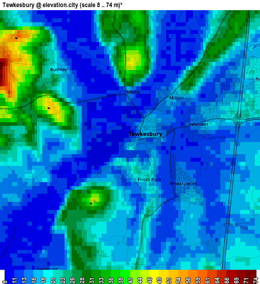
Below is the Elevation map of Tewkesbury, which displays elevation range with different colors. Scale of the first map is from 8 to 74 m (26 to 243 ft) with average elevation of 18.6 meters (=61 ft) [note 1]
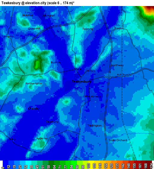
These maps also provides idea of topography and contour of this city, they are displayed at different zoom levels. More info about maps, scale and edge coordinates you can find below images.
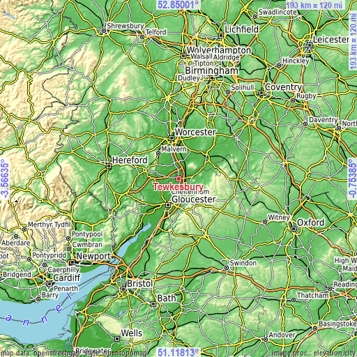
| \ | Map #1 | Map #2 | Topo.Map |
| Scale [m] | 8..74 m | 6..174 m | × |
| Scale [ft] | 26..243 ft | 20..571 ft | × |
| Average | 18.6 m = 61 ft | 23.6 m = 77 ft | × |
| Width | 6.02 km = 3.7 mi | 12.04 km = 7.5 mi | 192.6 km = 119.7 mi |
| Height | 6.02 km = 3.7 mi | 12.04 km = 7.5 mi | 192.6 km = 119.7 mi |
| ↑Max Latitude | 52.019492° | 52.046527° | 52.85001° |
| Latitude at center | 51.99244° | 51.99244° | 51.99244° |
| ↓Min Latitude | 51.965372° | 51.938287° | 51.11813° |
| ← Min Longitude | -2.204045° | -2.247991° | -3.56635° |
| Longitude center | -2.1601° | -2.1601° | -2.1601° |
| →Max Longitude | -2.116155° | -2.072209° | -0.75385° |
Nearby cities:
Cities around Tewkesbury sort by population:
• Cheltenham elevation 60 m
11.7 km,  151°
151°
• Bishops Cleeve 56 m
8.3 km,  126°
126°
• Churchdown 51 m
12.8 km,  183°
183°
• Charlton Kings 95 m
14.5 km, 146°
• Pershore 22 m
14.5 km,  23°
23°
• Winchcombe 93 m
14.1 km,  107°
107°
• Barnwood 29 m
14.6 km,  191°
191°
• Bredon 26 m
5.1 km,  35°
35°
• Upton upon Severn 16 m
8.7 km,  333°
333°
• Shurdington 70 m
14.7 km,  169°
169°
• Eckington 19 m
8.8 km, 19°
• Corse 27 m
10.7 km,  249°
249°
Multilingual:
 En español:
Tewkesbury elevación 12 m.
 En France:
Tewkesbury élévation 12 m.
 Auf Deutsch:
Tewkesbury höhe über dem Meeresspiegel ist 12 m.

Sources and notes:
- [note 1] Map square and city borders are not equal. Map elevation data is calculated only from area inside that square.
- [src 1] Elevation data from geonames database provided with same terms of usage.
- [src 2] The elevation map of Tewkesbury is generated using elevation data from NASA's 3 arcsec (90m) resolution SRTM data.
- [src 3] Base (background) map © OpenStreetMap contributors tiles are generated by Geofabrik and OpenTopoMap.
Copyright & License:
This Tewkesbury Elevation Map is licensed under CC BY-SA. You may reuse any part from this page, if you give a proper credit by linking to this URL:
 More info on terms of use page.