Watford elevation
Watford (England, Hertfordshire), United Kingdom elevation is 77 meters and Watford elevation in feet is 253 ft above sea level [src 1]. Watford is a populated place (feature code) with elevation that is 5 meters (16 ft) bigger than average city elevation in United Kingdom.
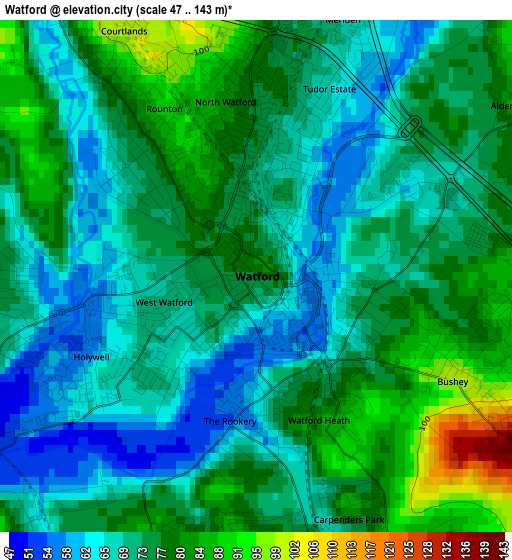
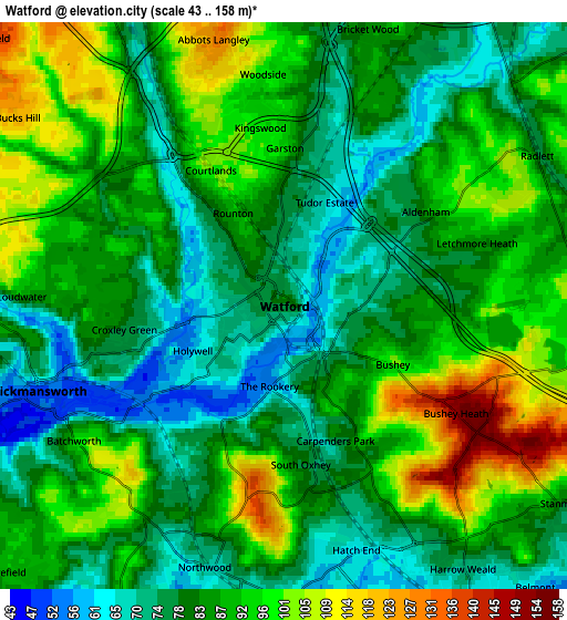
Below is the Elevation map of Watford, which displays elevation range with different colors. Scale of the first map is from 47 to 143 m (154 to 469 ft) with average elevation of 73.7 meters (=242 ft) [note 1]
These maps also provides idea of topography and contour of this city, they are displayed at different zoom levels. More info about maps, scale and edge coordinates you can find below images.
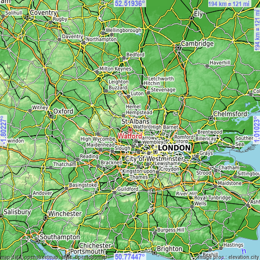
| \ | Map #1 | Map #2 | Topo.Map |
| Scale [m] | 47..143 m | 43..158 m | × |
| Scale [ft] | 154..469 ft | 141..518 ft | × |
| Average | 73.7 m = 242 ft | 85.8 m = 281 ft | × |
| Width | 6.06 km = 3.8 mi | 12.13 km = 7.5 mi | 194 km = 120.5 mi |
| Height | 6.06 km = 3.8 mi | 12.13 km = 7.5 mi | 194 km = 120.5 mi |
| ↑Max Latitude | 51.682565° | 51.709804° | 52.51936° |
| Latitude at center | 51.65531° | 51.65531° | 51.65531° |
| ↓Min Latitude | 51.628039° | 51.600751° | 50.77447° |
| ← Min Longitude | -0.439965° | -0.483911° | -1.80227° |
| Longitude center | -0.39602° | -0.39602° | -0.39602° |
| →Max Longitude | -0.352075° | -0.308129° | 1.01023° |
Nearby cities:
Cities around Watford sort by population:
• Borehamwood elevation 92 m
8.2 km,  90°
90°
• Pinner 53 m
6.9 km,  172°
172°
• Bushey 99 m
2.8 km,  118°
118°
• Rickmansworth 53 m
5.9 km,  252°
252°
• Chorleywood 113 m
8.1 km,  269°
269°
• Abbots Langley 128 m
5.8 km,  345°
345°
• Radlett 74 m
6.3 km,  57°
57°
• Kings Langley 93 m
7.5 km,  330°
330°
• Harefield 87 m
8.5 km,  226°
226°
• Stanmore 92 m
7 km,  128°
128°
• Maple Cross 47 m
8.4 km, 246°
• Elstree 129 m
7 km,  103°
103°
Multilingual:
 En español:
Watford elevación 77 m.
 En France:
Watford élévation 77 m.


Sources and notes:
- [note 1] Map square and city borders are not equal. Map elevation data is calculated only from area inside that square.
- [src 1] Elevation data from geonames database provided with same terms of usage.
- [src 2] The elevation map of Watford is generated using elevation data from NASA's 3 arcsec (90m) resolution SRTM data.
- [src 3] Base (background) map © OpenStreetMap contributors tiles are generated by Geofabrik and OpenTopoMap.
Copyright & License:
This Watford Elevation Map is licensed under CC BY-SA. You may reuse any part from this page, if you give a proper credit by linking to this URL:
 More info on terms of use page.