Wem elevation
Wem (England, Shropshire), United Kingdom elevation is 82 meters and Wem elevation in feet is 269 ft above sea level [src 1]. Wem is a populated place (feature code) with elevation that is 10 meters (33 ft) bigger than average city elevation in United Kingdom.
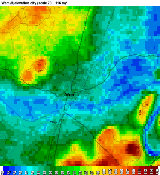
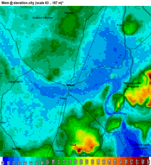
Below is the Elevation map of Wem, which displays elevation range with different colors. Scale of the first map is from 70 to 116 m (230 to 381 ft) with average elevation of 85.9 meters (=282 ft) [note 1]
These maps also provides idea of topography and contour of this city, they are displayed at different zoom levels. More info about maps, scale and edge coordinates you can find below images.
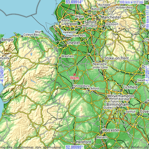
| \ | Map #1 | Map #2 | Topo.Map |
| Scale [m] | 70..116 m | 63..187 m | × |
| Scale [ft] | 230..381 ft | 207..614 ft | × |
| Average | 85.9 m = 282 ft | 91.2 m = 299 ft | × |
| Width | 5.9 km = 3.7 mi | 11.8 km = 7.3 mi | 188.8 km = 117.3 mi |
| Height | 5.9 km = 3.7 mi | 11.8 km = 7.3 mi | 188.8 km = 117.3 mi |
| ↑Max Latitude | 52.884876° | 52.911385° | 53.69914° |
| Latitude at center | 52.85835° | 52.85835° | 52.85835° |
| ↓Min Latitude | 52.831808° | 52.80525° | 52.00095° |
| ← Min Longitude | -2.762205° | -2.806151° | -4.12451° |
| Longitude center | -2.71826° | -2.71826° | -2.71826° |
| →Max Longitude | -2.674315° | -2.630369° | -1.31201° |
Nearby cities:
Cities around Wem sort by population:
• Whitchurch elevation 101 m
12.3 km,  11°
11°
• Ellesmere 94 m
13.3 km,  294°
294°
• Shawbury 73 m
8.4 km,  153°
153°
• Ash 112 m
11.2 km,  24°
24°
• Baschurch 84 m
11.9 km,  229°
229°
• Ruyton-XI-Towns 78 m
14.3 km,  240°
240°
• Prees 100 m
5.6 km,  40°
40°
• Clive 124 m
5 km,  183°
183°
• Great Ness 91 m
15.7 km, 227°
• Stoke upon Tern 64 m
12.5 km,  94°
94°
• Astley 71 m
10.3 km,  173°
173°
• Petton 119 m
8.2 km,  250°
250°
Multilingual:
 En español:
Wem elevación 82 m.
 En France:
Wem élévation 82 m.


Sources and notes:
- [note 1] Map square and city borders are not equal. Map elevation data is calculated only from area inside that square.
- [src 1] Elevation data from geonames database provided with same terms of usage.
- [src 2] The elevation map of Wem is generated using elevation data from NASA's 3 arcsec (90m) resolution SRTM data.
- [src 3] Base (background) map © OpenStreetMap contributors tiles are generated by Geofabrik and OpenTopoMap.
Copyright & License:
This Wem Elevation Map is licensed under CC BY-SA. You may reuse any part from this page, if you give a proper credit by linking to this URL:
 More info on terms of use page.