Wragby elevation
Wragby (England, Lincolnshire), United Kingdom elevation is 26 meters and Wragby elevation in feet is 85 ft above sea level [src 1]. Wragby is a populated place (feature code) with elevation that is 46 meters (151 ft) smaller than average city elevation in United Kingdom.
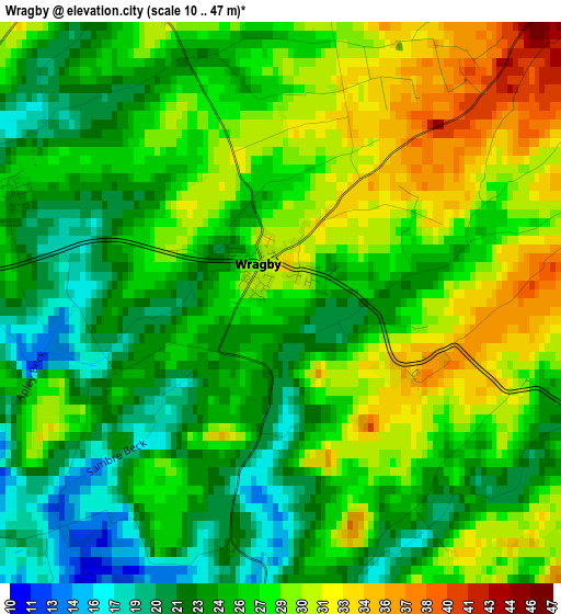
Below is the Elevation map of Wragby, which displays elevation range with different colors. Scale of the first map is from 10 to 47 m (33 to 154 ft) with average elevation of 26.4 meters (=87 ft) [note 1]
These maps also provides idea of topography and contour of this city, they are displayed at different zoom levels. More info about maps, scale and edge coordinates you can find below images.
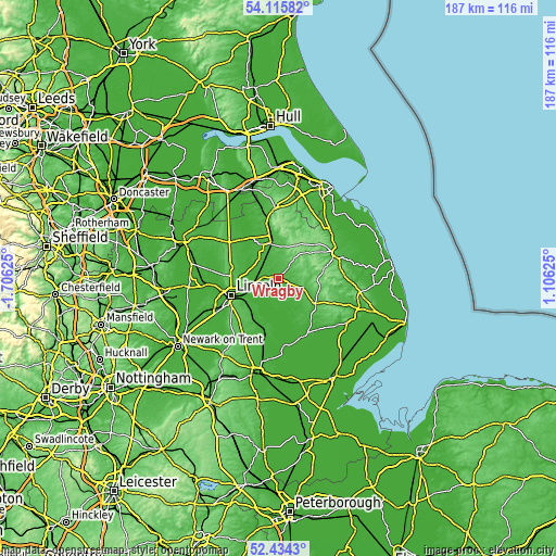
| \ | Map #1 | Topo.Map |
| Scale [m] | 10..47 m | × |
| Scale [ft] | 33..154 ft | × |
| Average | 26.4 m = 87 ft | × |
| Width | 5.84 km = 3.6 mi | 187 km = 116.2 mi |
| Height | 5.84 km = 3.6 mi | 187 km = 116.2 mi |
| ↑Max Latitude | 53.309595° | 54.11582° |
| Latitude at center | 53.28333° | 53.28333° |
| ↓Min Latitude | 53.257049° | 52.4343° |
| ← Min Longitude | -0.343945° | -1.70625° |
| Longitude center | -0.3° | -0.3° |
| →Max Longitude | -0.256055° | 1.10625° |
Nearby cities:
Cities around Wragby sort by population:
• Horncastle elevation 33 m
14.8 km,  124°
124°
• Washingborough 10 m
13.4 km,  240°
240°
• Heighington 16 m
13.2 km,  233°
233°
• Dunholme 16 m
11.2 km,  279°
279°
• Market Rasen 28 m
11.9 km,  347°
347°
• Woodhall Spa 15 m
15.7 km,  158°
158°
• Branston 40 m
15.2 km, 229°
• Nettleham 27 m
12.7 km,  261°
261°
• Reepham 6 m
10.5 km, 237°
• Sudbrooke 19 m
10.1 km, 259°
• Bardney 16 m
8.3 km,  190°
190°
• Middle Rasen 22 m
12.3 km,  340°
340°
Multilingual:
 En español:
Wragby elevación 26 m.
 En France:
Wragby élévation 26 m.


Sources and notes:
- [note 1] Map square and city borders are not equal. Map elevation data is calculated only from area inside that square.
- [src 1] Elevation data from geonames database provided with same terms of usage.
- [src 2] The elevation map of Wragby is generated using elevation data from NASA's 3 arcsec (90m) resolution SRTM data.
- [src 3] Base (background) map © OpenStreetMap contributors tiles are generated by Geofabrik and OpenTopoMap.
Copyright & License:
This Wragby Elevation Map is licensed under CC BY-SA. You may reuse any part from this page, if you give a proper credit by linking to this URL:
 More info on terms of use page.