Wroughton elevation
Wroughton (England, Borough of Swindon), United Kingdom elevation is 118 meters and Wroughton elevation in feet is 387 ft above sea level [src 1]. Wroughton is a populated place (feature code) with elevation that is 46 meters (151 ft) bigger than average city elevation in United Kingdom.
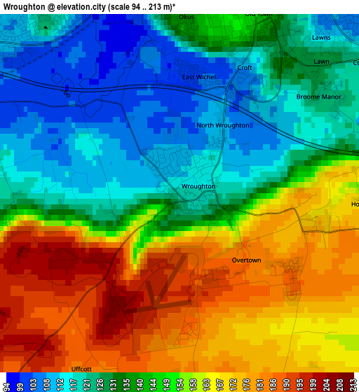
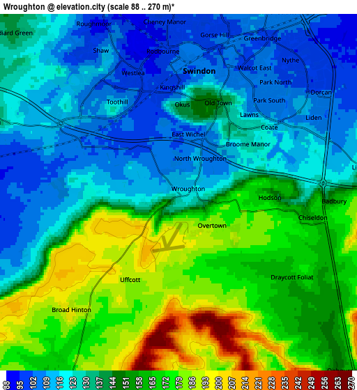
Below is the Elevation map of Wroughton, which displays elevation range with different colors. Scale of the first map is from 94 to 213 m (308 to 699 ft) with average elevation of 145.4 meters (=477 ft) [note 1]
These maps also provides idea of topography and contour of this city, they are displayed at different zoom levels. More info about maps, scale and edge coordinates you can find below images.
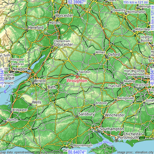
| \ | Map #1 | Map #2 | Topo.Map |
| Scale [m] | 94..213 m | 88..270 m | × |
| Scale [ft] | 308..699 ft | 289..886 ft | × |
| Average | 145.4 m = 477 ft | 142.6 m = 468 ft | × |
| Width | 6.08 km = 3.8 mi | 12.16 km = 7.6 mi | 194.6 km = 120.9 mi |
| Height | 6.08 km = 3.8 mi | 12.16 km = 7.6 mi | 194.6 km = 120.9 mi |
| ↑Max Latitude | 51.551444° | 51.578761° | 52.39067° |
| Latitude at center | 51.52411° | 51.52411° | 51.52411° |
| ↓Min Latitude | 51.49676° | 51.469393° | 50.64074° |
| ← Min Longitude | -1.839535° | -1.883481° | -3.20184° |
| Longitude center | -1.79559° | -1.79559° | -1.79559° |
| →Max Longitude | -1.751645° | -1.707699° | -0.38934° |
Nearby cities:
Cities around Wroughton sort by population:
• Swindon elevation 113 m
3.9 km,  14°
14°
• Royal Wootton Bassett 129 m
7.8 km,  284°
284°
• Marlborough 130 m
12.4 km,  158°
158°
• Lyneham 120 m
11.9 km,  266°
266°
• Purton 105 m
9 km,  322°
322°
• Wanborough 151 m
7 km,  72°
72°
• Chiseldon 161 m
4.5 km,  101°
101°
• Broad Blunsdon 142 m
10 km, 6°
• Lydiard Millicent 121 m
7 km, 318°
• Bishopstone 129 m
10.7 km, 73°
• Fyfield 137 m
12 km,  175°
175°
• Lydiard Tregoze 117 m
4.7 km,  307°
307°
Multilingual:
 En español:
Wroughton elevación 118 m.
 En France:
Wroughton élévation 118 m.
 Auf Deutsch:
Wroughton höhe über dem Meeresspiegel ist 118 m.

Sources and notes:
- [note 1] Map square and city borders are not equal. Map elevation data is calculated only from area inside that square.
- [src 1] Elevation data from geonames database provided with same terms of usage.
- [src 2] The elevation map of Wroughton is generated using elevation data from NASA's 3 arcsec (90m) resolution SRTM data.
- [src 3] Base (background) map © OpenStreetMap contributors tiles are generated by Geofabrik and OpenTopoMap.
Copyright & License:
This Wroughton Elevation Map is licensed under CC BY-SA. You may reuse any part from this page, if you give a proper credit by linking to this URL:
 More info on terms of use page.