Youlgreave elevation
Youlgreave (England, Derbyshire), United Kingdom elevation is 187 meters and Youlgreave elevation in feet is 614 ft above sea level [src 1]. Youlgreave is a populated place (feature code) with elevation that is 115 meters (377 ft) bigger than average city elevation in United Kingdom.
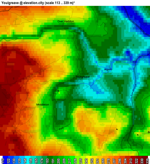
Below is the Elevation map of Youlgreave, which displays elevation range with different colors. Scale of the first map is from 113 to 339 m (371 to 1112 ft) with average elevation of 226.7 meters (=744 ft) [note 1]
These maps also provides idea of topography and contour of this city, they are displayed at different zoom levels. More info about maps, scale and edge coordinates you can find below images.
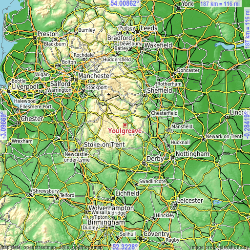
| \ | Map #1 | Topo.Map |
| Scale [m] | 113..339 m | × |
| Scale [ft] | 371..1112 ft | × |
| Average | 226.7 m = 744 ft | × |
| Width | 5.86 km = 3.6 mi | 187.4 km = 116.4 mi |
| Height | 5.86 km = 3.6 mi | 187.4 km = 116.4 mi |
| ↑Max Latitude | 53.200322° | 54.00862° |
| Latitude at center | 53.17399° | 53.17399° |
| ↓Min Latitude | 53.147642° | 52.3228° |
| ← Min Longitude | -1.734385° | -3.09669° |
| Longitude center | -1.69044° | -1.69044° |
| →Max Longitude | -1.646495° | -0.28419° |
Nearby cities:
Cities around Youlgreave sort by population:
• Buxton elevation 316 m
17.3 km,  302°
302°
• Matlock 97 m
9.8 km,  113°
113°
• Newhaven 316 m
5.6 km,  227°
227°
• Wingerworth 151 m
17.4 km,  79°
79°
• Wirksworth 170 m
12.8 km,  142°
142°
• Bakewell 126 m
4.5 km,  13°
13°
• Walton 132 m
16.2 km,  70°
70°
• Cromford 101 m
11.3 km,  129°
129°
• Hathersage 160 m
17.5 km, 7°
• Tideswell 297 m
12.8 km,  334°
334°
• Tansley 165 m
12.4 km, 112°
• Baslow 122 m
9.4 km,  28°
28°
Multilingual:
 En español:
Youlgreave elevación 187 m.
 En France:
Youlgreave élévation 187 m.
 Auf Deutsch:
Youlgreave höhe über dem Meeresspiegel ist 187 m.

Sources and notes:
- [note 1] Map square and city borders are not equal. Map elevation data is calculated only from area inside that square.
- [src 1] Elevation data from geonames database provided with same terms of usage.
- [src 2] The elevation map of Youlgreave is generated using elevation data from NASA's 3 arcsec (90m) resolution SRTM data.
- [src 3] Base (background) map © OpenStreetMap contributors tiles are generated by Geofabrik and OpenTopoMap.
Copyright & License:
This Youlgreave Elevation Map is licensed under CC BY-SA. You may reuse any part from this page, if you give a proper credit by linking to this URL:
 More info on terms of use page.