La Villette elevation
La Villette (Provence-Alpes-Côte d'Azur, Département des Bouches-du-Rhône), France elevation is 20 meters and La Villette elevation in feet is 66 ft above sea level [src 1]. La Villette is a section of populated place (feature code) with elevation that is 154 meters (505 ft) smaller than average city elevation in France.
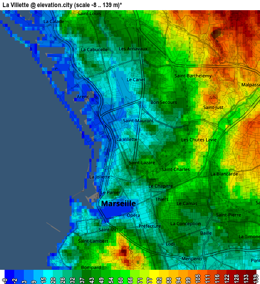
Below is the Elevation map of La Villette, which displays elevation range with different colors. Scale of the first map is from -8 to 139 m (-26 to 456 ft) with average elevation of 47.5 meters (=156 ft) [note 1]
These maps also provides idea of topography and contour of this city, they are displayed at different zoom levels. More info about maps, scale and edge coordinates you can find below images.
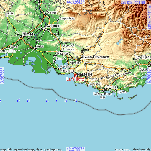
| \ | Map #1 | Map #2 | Topo.Map |
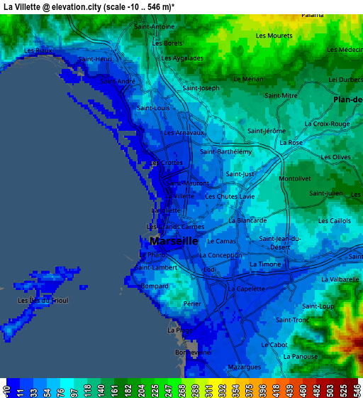
| Scale [m] | -8..139 m | -10..546 m | × |
| Scale [ft] | -26..456 ft | -33..1791 ft | × |
| Average | 47.5 m = 156 ft | 103.9 m = 341 ft | × |
| Width | 7.11 km = 4.4 mi | 14.22 km = 8.8 mi | 227.5 km = 141.4 mi |
| Height | 7.11 km = 4.4 mi | 14.22 km = 8.8 mi | 227.5 km = 141.4 mi |
| ↑Max Latitude | 43.343778° | 43.375728° | 44.32642° |
| Latitude at center | 43.31181° | 43.31181° | 43.31181° |
| ↓Min Latitude | 43.279826° | 43.247824° | 42.27997° |
| ← Min Longitude | 5.329965° | 5.286019° | 3.96766° |
| Longitude center | 5.37391° | 5.37391° | 5.37391° |
| →Max Longitude | 5.417855° | 5.461801° | 6.78016° |
Nearby cities:
Cities around La Villette sort by population:
• Marseille 03 elevation 32 m
1 km,  171°
171°
• Belle de Mai 60 m
0.9 km,  89°
89°
• Saint-Mauront 40 m
0.4 km,  16°
16°
• Bon-Secours 61 m
1.2 km,  45°
45°
• Saint-Lazare 38 m
0.7 km,  176°
176°
• Belsunce 40 m
1.5 km, 171°
• La Joliette 2 m
1 km,  217°
217°
• Saint-Charles 58 m
1.4 km,  143°
143°
• Les Grands Carmes 38 m
1.3 km, 184°
• Le Chapitre 58 m
1.5 km,  146°
146°
• Les Crottes 20 m
1.3 km,  339°
339°
• Arenc 20 m
0.7 km,  308°
308°
Multilingual:
 En español:
La Villette elevación 20 m.
 En France:
La Villette élévation 20 m.
 Auf Deutsch:
La Villette höhe über dem Meeresspiegel ist 20 m.

Sources and notes:
- [note 1] Map square and city borders are not equal. Map elevation data is calculated only from area inside that square.
- [src 1] Elevation data from geonames database provided with same terms of usage.
- [src 2] The elevation map of La Villette is generated using elevation data from NASA's 3 arcsec (90m) resolution SRTM data.
- [src 3] Base (background) map © OpenStreetMap contributors tiles are generated by Geofabrik and OpenTopoMap.
Copyright & License:
This La Villette Elevation Map is licensed under CC BY-SA. You may reuse any part from this page, if you give a proper credit by linking to this URL:
 More info on terms of use page.