Le Chapitre elevation
Le Chapitre (Provence-Alpes-Côte d'Azur, Département des Bouches-du-Rhône), France elevation is 58 meters and Le Chapitre elevation in feet is 190 ft above sea level [src 1]. Le Chapitre is a section of populated place (feature code) with elevation that is 116 meters (381 ft) smaller than average city elevation in France.
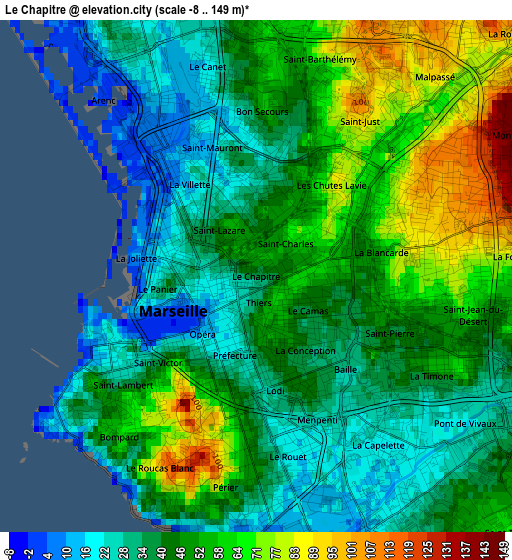
Below is the Elevation map of Le Chapitre, which displays elevation range with different colors. Scale of the first map is from -8 to 149 m (-26 to 489 ft) with average elevation of 46.4 meters (=152 ft) [note 1]
These maps also provides idea of topography and contour of this city, they are displayed at different zoom levels. More info about maps, scale and edge coordinates you can find below images.
| \ | Map #1 | Map #2 | Topo.Map |
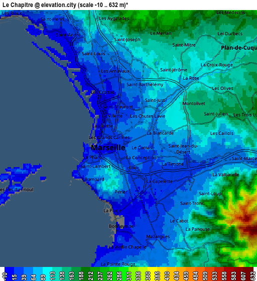
| Scale [m] | -8..149 m | -10..632 m | × |
| Scale [ft] | -26..489 ft | -33..2073 ft | × |
| Average | 46.4 m = 152 ft | 102 m = 335 ft | × |
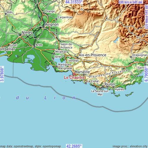
| Width | 7.11 km = 4.4 mi | 14.22 km = 8.8 mi | 227.6 km = 141.4 mi |
| Height | 7.11 km = 4.4 mi | 14.22 km = 8.8 mi | 227.6 km = 141.4 mi |
| ↑Max Latitude | 43.332504° | 43.36446° | 44.31533° |
| Latitude at center | 43.30053° | 43.30053° | 43.30053° |
| ↓Min Latitude | 43.26854° | 43.236533° | 42.2685° |
| ← Min Longitude | 5.340385° | 5.296439° | 3.97808° |
| Longitude center | 5.38433° | 5.38433° | 5.38433° |
| →Max Longitude | 5.428275° | 5.472221° | 6.79058° |
Nearby cities:
Cities around Le Chapitre sort by population:
• Marseille elevation 28 m
0.5 km,  213°
213°
• Marseille 03 32 m
0.7 km,  288°
288°
• Marseille 01 32 m
0.3 km,  184°
184°
• Le Camas 40 m
1 km,  129°
129°
• Saint-Lazare 38 m
1 km,  304°
304°
• Belsunce 40 m
0.7 km,  248°
248°
• Saint-Charles 58 m
0.2 km,  352°
352°
• Les Grands Carmes 38 m
0.9 km,  268°
268°
• Notre-Dame du Mont 40 m
0.9 km,  192°
192°
• Thiers 40 m
0.4 km, 209°
• Noailles 40 m
0.6 km,  217°
217°
• Opéra 40 m
1 km, 222°
Multilingual:
 En español:
Le Chapitre elevación 58 m.
 En France:
Le Chapitre élévation 58 m.
 Auf Deutsch:
Le Chapitre höhe über dem Meeresspiegel ist 58 m.

Sources and notes:
- [note 1] Map square and city borders are not equal. Map elevation data is calculated only from area inside that square.
- [src 1] Elevation data from geonames database provided with same terms of usage.
- [src 2] The elevation map of Le Chapitre is generated using elevation data from NASA's 3 arcsec (90m) resolution SRTM data.
- [src 3] Base (background) map © OpenStreetMap contributors tiles are generated by Geofabrik and OpenTopoMap.
Copyright & License:
This Le Chapitre Elevation Map is licensed under CC BY-SA. You may reuse any part from this page, if you give a proper credit by linking to this URL:
 More info on terms of use page.