Rd pt des Chataigniers, Rte de Milizac, Guilers, Finistère, France elevation
Rd pt des Chataigniers, Rte de Milizac, Guilers, Finistère, France (Brittany, Département du Finistère), France elevation is 90 meters and Rd pt des Chataigniers, Rte de Milizac, Guilers, Finistère, France elevation in feet is 295 ft above sea level [src 1]. Rd pt des Chataigniers, Rte de Milizac, Guilers, Finistère, France is a populated locality (feature code) with elevation that is 84 meters (276 ft) smaller than average city elevation in France.
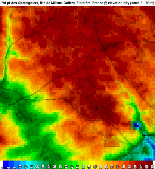
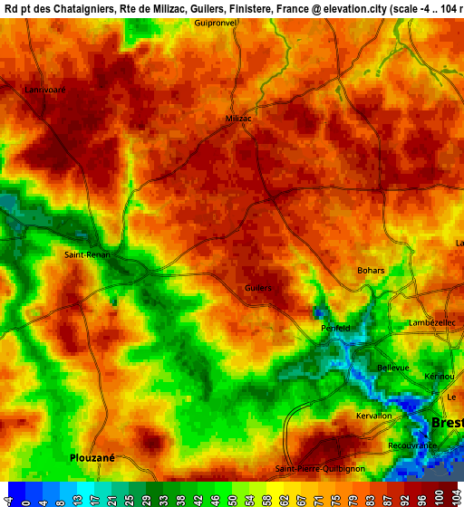
Below is the Elevation map of Rd pt des Chataigniers, Rte de Milizac, Guilers, Finistère, France, which displays elevation range with different colors. Scale of the first map is from 2 to 99 m (7 to 325 ft) with average elevation of 73.7 meters (=242 ft) [note 1]
These maps also provides idea of topography and contour of this city, they are displayed at different zoom levels. More info about maps, scale and edge coordinates you can find below images.
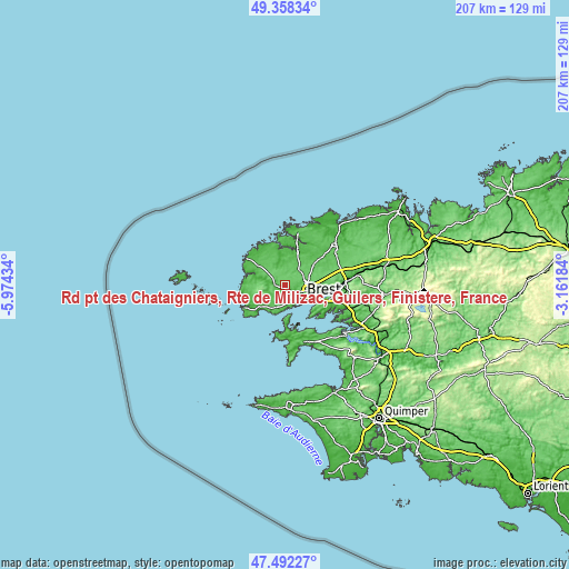
| \ | Map #1 | Map #2 | Topo.Map |
| Scale [m] | 2..99 m | -4..104 m | × |
| Scale [ft] | 7..325 ft | -13..341 ft | × |
| Average | 73.7 m = 242 ft | 69.9 m = 229 ft | × |
| Width | 6.48 km = 4 mi | 12.97 km = 8.1 mi | 207.5 km = 128.9 mi |
| Height | 6.48 km = 4 mi | 12.97 km = 8.1 mi | 207.5 km = 128.9 mi |
| ↑Max Latitude | 48.463019° | 48.492151° | 49.35834° |
| Latitude at center | 48.43387° | 48.43387° | 48.43387° |
| ↓Min Latitude | 48.404705° | 48.375523° | 47.49227° |
| ← Min Longitude | -4.612035° | -4.655981° | -5.97434° |
| Longitude center | -4.56809° | -4.56809° | -4.56809° |
| →Max Longitude | -4.524145° | -4.480199° | -3.16184° |
Nearby cities:
Cities around Rd pt des Chataigniers, Rte de Milizac, Guilers, Finistère, France sort by population:
• Brest elevation 49 m
7.7 km,  128°
128°
• Plouzané 82 m
6.7 km,  212°
212°
• Guilers 93 m
1.2 km,  141°
141°
• Saint-Renan 35 m
3.6 km,  269°
269°
• Gouesnou 87 m
7.9 km,  74°
74°
• Bohars 71 m
4.1 km,  96°
96°
• Bourg-Blanc 60 m
8.6 km,  33°
33°
• Milizac 88 m
3.6 km,  1°
1°
• Plouarzel 74 m
12.2 km, 269°
• Plouguin 48 m
11.3 km,  347°
347°
• Ploumoguer 69 m
11.6 km,  251°
251°
• Lanrivoaré 90 m
6.8 km,  309°
309°
Multilingual:
 En español:
Rd pt des Chataigniers, Rte de Milizac, Guilers, Finistère, France elevación 90 m.
 En France:
Rd pt des Chataigniers, Rte de Milizac, Guilers, Finistère, France élévation 90 m.
 Auf Deutsch:
Rd pt des Chataigniers, Rte de Milizac, Guilers, Finistère, France höhe über dem Meeresspiegel ist 90 m.
 На русском:
Rd pt des Chataigniers, Rte de Milizac, Guilers, Finistère, France высота над уровнем моря 90 м
Sources and notes:
- [note 1] Map square and city borders are not equal. Map elevation data is calculated only from area inside that square.
- [src 1] Elevation data from geonames database provided with same terms of usage.
- [src 2] The elevation map of Rd pt des Chataigniers, Rte de Milizac, Guilers, Finistère, France is generated using elevation data from NASA's 3 arcsec (90m) resolution SRTM data.
- [src 3] Base (background) map © OpenStreetMap contributors tiles are generated by Geofabrik and OpenTopoMap.
Copyright & License:
This Rd pt des Chataigniers, Rte de Milizac, Guilers, Finistère, France Elevation Map is licensed under CC BY-SA. You may reuse any part from this page, if you give a proper credit by linking to this URL:
 More info on terms of use page.