Saint-Manvieu-Norrey elevation
Saint-Manvieu-Norrey (Normandy, Calvados), France elevation is 78 meters and Saint-Manvieu-Norrey elevation in feet is 256 ft above sea level [src 1]. Saint-Manvieu-Norrey is a populated place (feature code) with elevation that is 96 meters (315 ft) smaller than average city elevation in France.
Below is the Elevation map of Saint-Manvieu-Norrey, which displays elevation range with different colors. Scale of the first map is from 38 to 112 m (125 to 367 ft) with average elevation of 72.9 meters (=239 ft) [note 1]
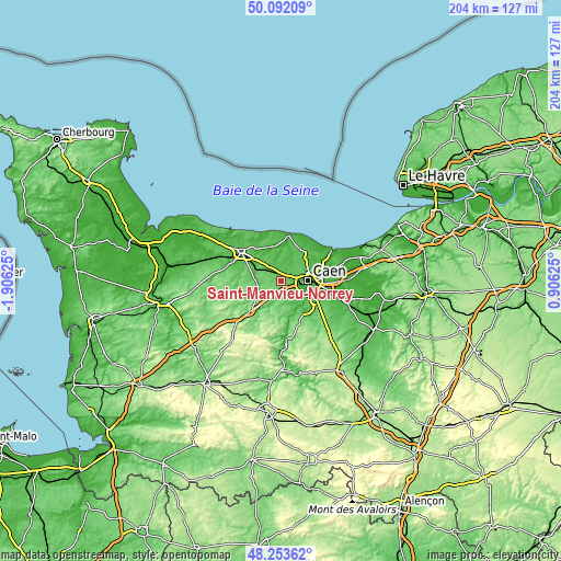
These maps also provides idea of topography and contour of this city, they are displayed at different zoom levels. More info about maps, scale and edge coordinates you can find below images.
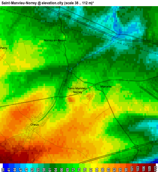
| \ | Map #1 | Topo.Map |
| Scale [m] | 38..112 m | × |
| Scale [ft] | 125..367 ft | × |
| Average | 72.9 m = 239 ft | × |
| Width | 6.39 km = 4 mi | 204.4 km = 127 mi |
| Height | 6.39 km = 4 mi | 204.4 km = 127 mi |
| ↑Max Latitude | 49.210107° | 50.09209° |
| Latitude at center | 49.18139° | 49.18139° |
| ↓Min Latitude | 49.152656° | 48.25362° |
| ← Min Longitude | -0.543945° | -1.90625° |
| Longitude center | -0.5° | -0.5° |
| →Max Longitude | -0.456055° | 0.90625° |
Nearby cities:
Cities around Saint-Manvieu-Norrey sort by population:
• Bretteville-sur-Odon elevation 18 m
6.3 km,  105°
105°
• Verson 47 m
4.4 km,  133°
133°
• Bretteville-l’Orgueilleuse 55 m
3.5 km,  342°
342°
• Carpiquet 58 m
3.9 km,  83°
83°
• Fontaine-Étoupefour 53 m
5.1 km,  140°
140°
• Saint-Manvieu 78 m
0.2 km,  242°
242°
• Rots 50 m
4 km,  29°
29°
• Mouen 75 m
4 km,  162°
162°
• Cheux 82 m
2.5 km,  227°
227°
• Tourville-sur-Odon 77 m
4.4 km,  181°
181°
• Authie 66 m
5.7 km,  60°
60°
• Grainville-sur-Odon 99 m
5.2 km,  205°
205°
Multilingual:
 En español:
Saint-Manvieu-Norrey elevación 78 m.
 En France:
Saint-Manvieu-Norrey élévation 78 m.
 Auf Deutsch:
Saint-Manvieu-Norrey höhe über dem Meeresspiegel ist 78 m.
 На русском:
Saint-Manvieu-Norrey высота над уровнем моря 78 м
Sources and notes:
- [note 1] Map square and city borders are not equal. Map elevation data is calculated only from area inside that square.
- [src 1] Elevation data from geonames database provided with same terms of usage.
- [src 2] The elevation map of Saint-Manvieu-Norrey is generated using elevation data from NASA's 3 arcsec (90m) resolution SRTM data.
- [src 3] Base (background) map © OpenStreetMap contributors tiles are generated by Geofabrik and OpenTopoMap.
Copyright & License:
This Saint-Manvieu-Norrey Elevation Map is licensed under CC BY-SA. You may reuse any part from this page, if you give a proper credit by linking to this URL:
 More info on terms of use page.