Authie elevation
Authie (Normandy, Calvados), France elevation is 66 meters and Authie elevation in feet is 217 ft above sea level [src 1]. Authie is a populated place (feature code) with elevation that is 108 meters (354 ft) smaller than average city elevation in France.
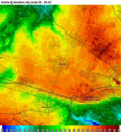
Below is the Elevation map of Authie, which displays elevation range with different colors. Scale of the first map is from 20 to 84 m (66 to 276 ft) with average elevation of 59.7 meters (=196 ft) [note 1]
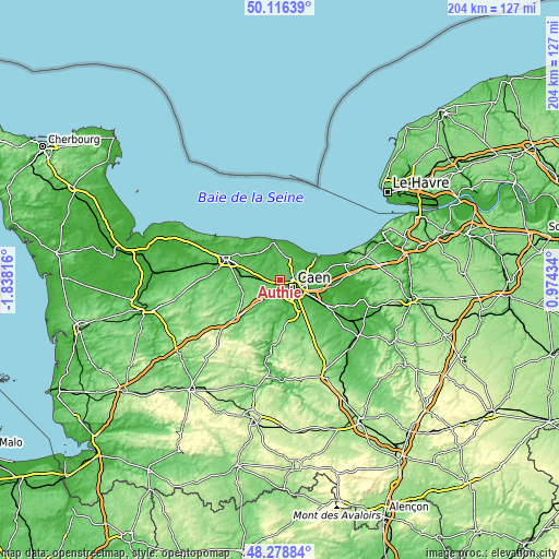
These maps also provides idea of topography and contour of this city, they are displayed at different zoom levels. More info about maps, scale and edge coordinates you can find below images.
| \ | Map #1 | Topo.Map |
| Scale [m] | 20..84 m | × |
| Scale [ft] | 66..276 ft | × |
| Average | 59.7 m = 196 ft | × |
| Width | 6.38 km = 4 mi | 204.3 km = 126.9 mi |
| Height | 6.38 km = 4 mi | 204.3 km = 126.9 mi |
| ↑Max Latitude | 49.234853° | 50.11639° |
| Latitude at center | 49.20615° | 49.20615° |
| ↓Min Latitude | 49.17743° | 48.27884° |
| ← Min Longitude | -0.475855° | -1.83816° |
| Longitude center | -0.43191° | -0.43191° |
| →Max Longitude | -0.387965° | 0.97434° |
Nearby cities:
Cities around Authie sort by population:
• Caen elevation 21 m
5.8 km,  113°
113°
• Bretteville-sur-Odon 18 m
4.6 km,  165°
165°
• Verson 47 m
6 km,  197°
197°
• Saint-Germain-la-Blanche-Herbe 40 m
3.2 km,  141°
141°
• Saint-Contest 74 m
2.3 km,  67°
67°
• Carpiquet 58 m
2.5 km, 204°
• Épron 54 m
4.8 km, 68°
• Cairon 37 m
4 km,  340°
340°
• Saint-Manvieu 78 m
5.8 km,  240°
240°
• Cambes-en-Plaine 57 m
4.4 km,  50°
50°
• Saint-Manvieu-Norrey 78 m
5.7 km, 240°
• Rots 50 m
3.1 km,  282°
282°
Multilingual:
 En español:
Authie elevación 66 m.
 En France:
Authie élévation 66 m.


Sources and notes:
- [note 1] Map square and city borders are not equal. Map elevation data is calculated only from area inside that square.
- [src 1] Elevation data from geonames database provided with same terms of usage.
- [src 2] The elevation map of Authie is generated using elevation data from NASA's 3 arcsec (90m) resolution SRTM data.
- [src 3] Base (background) map © OpenStreetMap contributors tiles are generated by Geofabrik and OpenTopoMap.
Copyright & License:
This Authie Elevation Map is licensed under CC BY-SA. You may reuse any part from this page, if you give a proper credit by linking to this URL:
 More info on terms of use page.