Ansauvillers elevation
Ansauvillers (Hauts-de-France, Département de l'Oise), France elevation is 147 meters and Ansauvillers elevation in feet is 482 ft above sea level [src 1]. Ansauvillers is a populated place (feature code) with elevation that is 27 meters (89 ft) smaller than average city elevation in France.
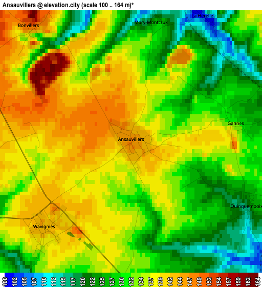
Below is the Elevation map of Ansauvillers, which displays elevation range with different colors. Scale of the first map is from 100 to 164 m (328 to 538 ft) with average elevation of 133.5 meters (=438 ft) [note 1]
These maps also provides idea of topography and contour of this city, they are displayed at different zoom levels. More info about maps, scale and edge coordinates you can find below images.
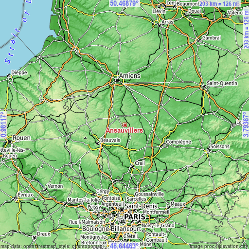
| \ | Map #1 | Topo.Map |
| Scale [m] | 100..164 m | × |
| Scale [ft] | 328..538 ft | × |
| Average | 133.5 m = 438 ft | × |
| Width | 6.34 km = 3.9 mi | 202.8 km = 126 mi |
| Height | 6.34 km = 3.9 mi | 202.8 km = 126 mi |
| ↑Max Latitude | 49.593724° | 50.46879° |
| Latitude at center | 49.56523° | 49.56523° |
| ↓Min Latitude | 49.53672° | 48.64463° |
| ← Min Longitude | 2.343475° | 0.98117° |
| Longitude center | 2.38742° | 2.38742° |
| →Max Longitude | 2.431365° | 3.79367° |
Nearby cities:
Cities around Ansauvillers sort by population:
• Clermont elevation 96 m
20.8 km,  174°
174°
• Montdidier 90 m
16 km,  55°
55°
• Saint-Just-en-Chaussée 99 m
7.5 km,  153°
153°
• Breteuil 83 m
10.1 km,  318°
318°
• Bresles 61 m
19.9 km,  209°
209°
• Agnetz 84 m
20.5 km,  180°
180°
• Maignelay-Montigny 116 m
9.5 km,  100°
100°
• Fitz-James 61 m
19.6 km, 170°
• Tricot 97 m
14.5 km,  91°
91°
• Avrechy 86 m
13.4 km, 167°
• Ravenel 112 m
10 km,  123°
123°
• Wavignies 143 m
2.8 km,  224°
224°
Multilingual:
 En español:
Ansauvillers elevación 147 m.
 En France:
Ansauvillers élévation 147 m.
 Auf Deutsch:
Ansauvillers höhe über dem Meeresspiegel ist 147 m.

Sources and notes:
- [note 1] Map square and city borders are not equal. Map elevation data is calculated only from area inside that square.
- [src 1] Elevation data from geonames database provided with same terms of usage.
- [src 2] The elevation map of Ansauvillers is generated using elevation data from NASA's 3 arcsec (90m) resolution SRTM data.
- [src 3] Base (background) map © OpenStreetMap contributors tiles are generated by Geofabrik and OpenTopoMap.
Copyright & License:
This Ansauvillers Elevation Map is licensed under CC BY-SA. You may reuse any part from this page, if you give a proper credit by linking to this URL:
 More info on terms of use page.