Ravenel elevation
Ravenel (Hauts-de-France, Département de l'Oise), France elevation is 112 meters and Ravenel elevation in feet is 367 ft above sea level [src 1]. Ravenel is a populated place (feature code) with elevation that is 62 meters (203 ft) smaller than average city elevation in France.
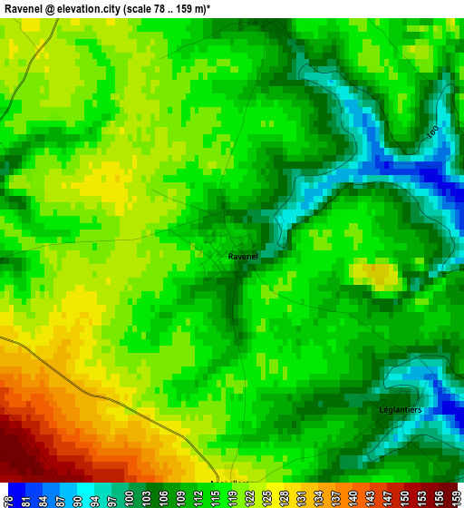
Below is the Elevation map of Ravenel, which displays elevation range with different colors. Scale of the first map is from 78 to 159 m (256 to 522 ft) with average elevation of 115.4 meters (=379 ft) [note 1]
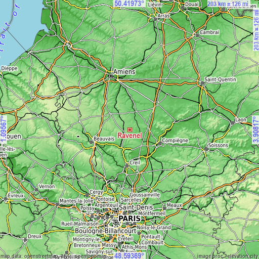
These maps also provides idea of topography and contour of this city, they are displayed at different zoom levels. More info about maps, scale and edge coordinates you can find below images.
| \ | Map #1 | Topo.Map |
| Scale [m] | 78..159 m | × |
| Scale [ft] | 256..522 ft | × |
| Average | 115.4 m = 379 ft | × |
| Width | 6.34 km = 3.9 mi | 203 km = 126.1 mi |
| Height | 6.34 km = 3.9 mi | 203 km = 126.1 mi |
| ↑Max Latitude | 49.543753° | 50.41973° |
| Latitude at center | 49.51523° | 49.51523° |
| ↓Min Latitude | 49.48669° | 48.59369° |
| ← Min Longitude | 2.457975° | 1.09567° |
| Longitude center | 2.50192° | 2.50192° |
| →Max Longitude | 2.545865° | 3.90817° |
Nearby cities:
Cities around Ravenel sort by population:
• Clermont elevation 96 m
16.5 km,  203°
203°
• Montdidier 90 m
15.6 km,  18°
18°
• Saint-Just-en-Chaussée 99 m
5.1 km,  257°
257°
• Estrées-Saint-Denis 71 m
14.2 km,  134°
134°
• Maignelay-Montigny 116 m
4 km, 15°
• Fitz-James 61 m
14.7 km, 200°
• Breuil-le-Sec 51 m
16.4 km,  192°
192°
• Tricot 97 m
8 km,  50°
50°
• Catenoy 60 m
16.4 km,  177°
177°
• Avrechy 86 m
9.2 km,  215°
215°
• Ansauvillers 147 m
10 km,  303°
303°
• Wavignies 143 m
10.8 km,  289°
289°
Multilingual:
 En español:
Ravenel elevación 112 m.
 En France:
Ravenel élévation 112 m.


Sources and notes:
- [note 1] Map square and city borders are not equal. Map elevation data is calculated only from area inside that square.
- [src 1] Elevation data from geonames database provided with same terms of usage.
- [src 2] The elevation map of Ravenel is generated using elevation data from NASA's 3 arcsec (90m) resolution SRTM data.
- [src 3] Base (background) map © OpenStreetMap contributors tiles are generated by Geofabrik and OpenTopoMap.
Copyright & License:
This Ravenel Elevation Map is licensed under CC BY-SA. You may reuse any part from this page, if you give a proper credit by linking to this URL:
 More info on terms of use page.