Antony elevation
Antony (Île-de-France, Hauts-de-Seine), France elevation is 52 meters and Antony elevation in feet is 171 ft above sea level [src 1]. Antony is a seat of a third-order administrative division (feature code) with elevation that is 122 meters (400 ft) smaller than average city elevation in France.
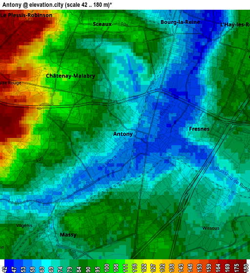
Below is the Elevation map of Antony, which displays elevation range with different colors. Scale of the first map is from 42 to 180 m (138 to 591 ft) with average elevation of 84.5 meters (=277 ft) [note 1]
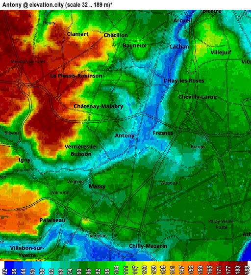
These maps also provides idea of topography and contour of this city, they are displayed at different zoom levels. More info about maps, scale and edge coordinates you can find below images.
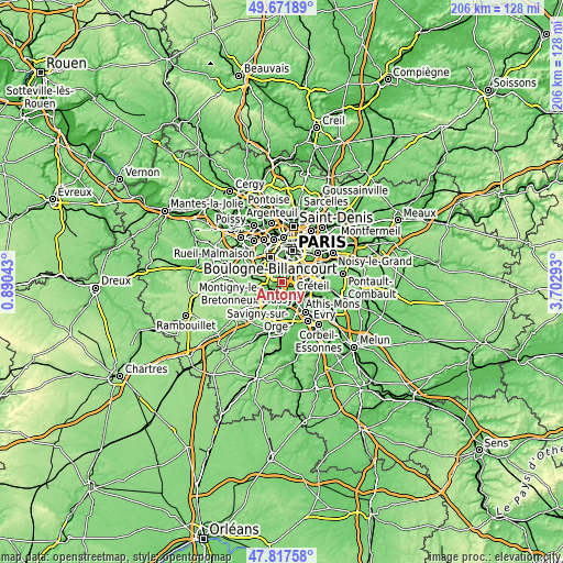
| \ | Map #1 | Map #2 | Topo.Map |
| Scale [m] | 42..180 m | 32..189 m | × |
| Scale [ft] | 138..591 ft | 105..620 ft | × |
| Average | 84.5 m = 277 ft | 97.9 m = 321 ft | × |
| Width | 6.44 km = 4 mi | 12.89 km = 8 mi | 206.2 km = 128.1 mi |
| Height | 6.44 km = 4 mi | 12.89 km = 8 mi | 206.2 km = 128.1 mi |
| ↑Max Latitude | 48.782255° | 48.811203° | 49.67189° |
| Latitude at center | 48.75329° | 48.75329° | 48.75329° |
| ↓Min Latitude | 48.724308° | 48.69531° | 47.81758° |
| ← Min Longitude | 2.252735° | 2.208789° | 0.89043° |
| Longitude center | 2.29668° | 2.29668° | 2.29668° |
| →Max Longitude | 2.340625° | 2.384571° | 3.70293° |
Nearby cities:
Cities around Antony sort by population:
• Massy elevation 84 m
3.1 km,  198°
198°
• Châtenay-Malabry 116 m
2.6 km,  300°
300°
• L'Haÿ-les-Roses 62 m
4.3 km,  38°
38°
• Fresnes 68 m
1.9 km,  81°
81°
• Le Plessis-Robinson 159 m
4.4 km,  334°
334°
• Sceaux 93 m
2.6 km,  349°
349°
• Chevilly-Larue 89 m
4.1 km,  72°
72°
• Chilly-Mazarin 83 m
4.5 km,  161°
161°
• Bourg-la-Reine 55 m
3.2 km,  28°
28°
• Verrières-le-Buisson 85 m
2.3 km,  248°
248°
• Rungis 86 m
4.2 km,  101°
101°
• Wissous 78 m
2.9 km,  138°
138°
Multilingual:
 En español:
Antony elevación 52 m.
 En France:
Antony élévation 52 m.


Sources and notes:
- [note 1] Map square and city borders are not equal. Map elevation data is calculated only from area inside that square.
- [src 1] Elevation data from geonames database provided with same terms of usage.
- [src 2] The elevation map of Antony is generated using elevation data from NASA's 3 arcsec (90m) resolution SRTM data.
- [src 3] Base (background) map © OpenStreetMap contributors tiles are generated by Geofabrik and OpenTopoMap.
Copyright & License:
This Antony Elevation Map is licensed under CC BY-SA. You may reuse any part from this page, if you give a proper credit by linking to this URL:
 More info on terms of use page.