Aramon elevation
Aramon (Occitanie, Gard), France elevation is 19 meters and Aramon elevation in feet is 62 ft above sea level [src 1]. Aramon is a populated place (feature code) with elevation that is 155 meters (509 ft) smaller than average city elevation in France.
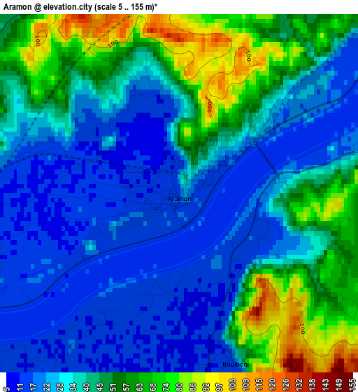
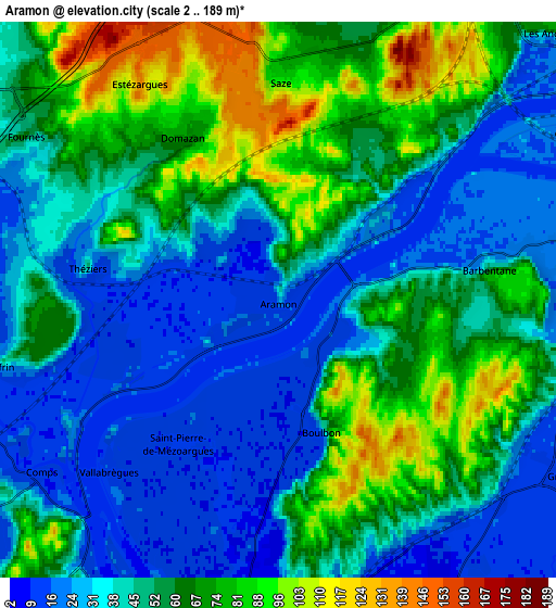
Below is the Elevation map of Aramon, which displays elevation range with different colors. Scale of the first map is from 5 to 155 m (16 to 509 ft) with average elevation of 38.7 meters (=127 ft) [note 1]
These maps also provides idea of topography and contour of this city, they are displayed at different zoom levels. More info about maps, scale and edge coordinates you can find below images.
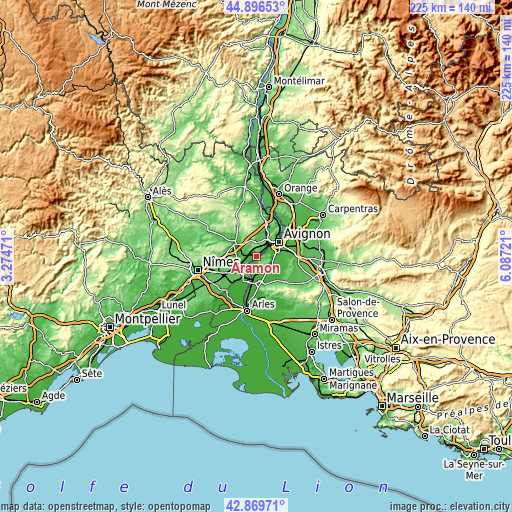
| \ | Map #1 | Map #2 | Topo.Map |
| Scale [m] | 5..155 m | 2..189 m | × |
| Scale [ft] | 16..509 ft | 7..620 ft | × |
| Average | 38.7 m = 127 ft | 50.6 m = 166 ft | × |
| Width | 7.04 km = 4.4 mi | 14.09 km = 8.8 mi | 225.4 km = 140.1 mi |
| Height | 7.04 km = 4.4 mi | 14.09 km = 8.8 mi | 225.4 km = 140.1 mi |
| ↑Max Latitude | 43.923401° | 43.955045° | 44.89653° |
| Latitude at center | 43.89174° | 43.89174° | 43.89174° |
| ↓Min Latitude | 43.860062° | 43.828368° | 42.86971° |
| ← Min Longitude | 4.637015° | 4.593069° | 3.27471° |
| Longitude center | 4.68096° | 4.68096° | 4.68096° |
| →Max Longitude | 4.724905° | 4.768851° | 6.08721° |
Nearby cities:
Cities around Aramon sort by population:
• Beaucaire elevation 22 m
9.8 km,  197°
197°
• Tarascon 16 m
9.7 km,  189°
189°
• Les Angles 67 m
9.9 km,  41°
41°
• Rochefort-du-Gard 108 m
9.5 km,  4°
4°
• Barbentane 82 m
5.4 km,  80°
80°
• Graveson 16 m
8.7 km,  121°
121°
• Montfrin 23 m
6.8 km,  254°
254°
• Meynes 63 m
9.8 km,  262°
262°
• Comps 15 m
7.4 km,  234°
234°
• Saze 85 m
5.7 km, 0°
• Boulbon 24 m
3.4 km,  162°
162°
• Vallabrègues 17 m
6.1 km, 225°
Multilingual:
 En español:
Aramon elevación 19 m.
 En France:
Aramon élévation 19 m.


Sources and notes:
- [note 1] Map square and city borders are not equal. Map elevation data is calculated only from area inside that square.
- [src 1] Elevation data from geonames database provided with same terms of usage.
- [src 2] The elevation map of Aramon is generated using elevation data from NASA's 3 arcsec (90m) resolution SRTM data.
- [src 3] Base (background) map © OpenStreetMap contributors tiles are generated by Geofabrik and OpenTopoMap.
Copyright & License:
This Aramon Elevation Map is licensed under CC BY-SA. You may reuse any part from this page, if you give a proper credit by linking to this URL:
 More info on terms of use page.