Barbentane elevation
Barbentane (Provence-Alpes-Côte d'Azur, Département des Bouches-du-Rhône), France elevation is 82 meters and Barbentane elevation in feet is 269 ft above sea level [src 1]. Barbentane is a populated place (feature code) with elevation that is 92 meters (302 ft) smaller than average city elevation in France.
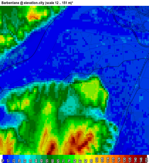
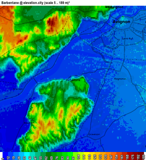
Below is the Elevation map of Barbentane, which displays elevation range with different colors. Scale of the first map is from 12 to 151 m (39 to 495 ft) with average elevation of 40.3 meters (=132 ft) [note 1]
These maps also provides idea of topography and contour of this city, they are displayed at different zoom levels. More info about maps, scale and edge coordinates you can find below images.
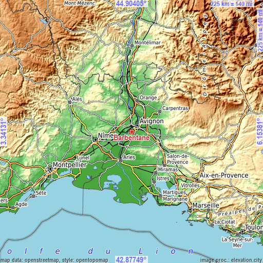
| \ | Map #1 | Map #2 | Topo.Map |
| Scale [m] | 12..151 m | 5..189 m | × |
| Scale [ft] | 39..495 ft | 16..620 ft | × |
| Average | 40.3 m = 132 ft | 45 m = 148 ft | × |
| Width | 7.04 km = 4.4 mi | 14.08 km = 8.7 mi | 225.3 km = 140 mi |
| Height | 7.04 km = 4.4 mi | 14.08 km = 8.7 mi | 225.3 km = 140 mi |
| ↑Max Latitude | 43.931047° | 43.962687° | 44.90405° |
| Latitude at center | 43.89939° | 43.89939° | 43.89939° |
| ↓Min Latitude | 43.867716° | 43.836026° | 42.87749° |
| ← Min Longitude | 4.703615° | 4.659669° | 3.34131° |
| Longitude center | 4.74756° | 4.74756° | 4.74756° |
| →Max Longitude | 4.791505° | 4.835451° | 6.15381° |
Nearby cities:
Cities around Barbentane sort by population:
• Avignon elevation 31 m
7.3 km,  42°
42°
• Châteaurenard 42 m
8.8 km,  102°
102°
• Villeneuve-lès-Avignon 21 m
8.6 km,  26°
26°
• Les Angles 67 m
6.6 km,  11°
11°
• Rochefort-du-Gard 108 m
9.7 km,  331°
331°
• Eyragues 28 m
10 km,  130°
130°
• Aramon 19 m
5.4 km,  260°
260°
• Rognonas 20 m
4.5 km,  89°
89°
• Graveson 16 m
5.8 km,  158°
158°
• Maillane 12 m
7.9 km, 159°
• Saze 85 m
7.2 km,  312°
312°
• Boulbon 24 m
6 km,  226°
226°
Multilingual:
 En español:
Barbentane elevación 82 m.
 En France:
Barbentane élévation 82 m.
 Auf Deutsch:
Barbentane höhe über dem Meeresspiegel ist 82 m.

Sources and notes:
- [note 1] Map square and city borders are not equal. Map elevation data is calculated only from area inside that square.
- [src 1] Elevation data from geonames database provided with same terms of usage.
- [src 2] The elevation map of Barbentane is generated using elevation data from NASA's 3 arcsec (90m) resolution SRTM data.
- [src 3] Base (background) map © OpenStreetMap contributors tiles are generated by Geofabrik and OpenTopoMap.
Copyright & License:
This Barbentane Elevation Map is licensed under CC BY-SA. You may reuse any part from this page, if you give a proper credit by linking to this URL:
 More info on terms of use page.