Aubin elevation
Aubin (Occitanie, Département de l'Aveyron), France elevation is 247 meters and Aubin elevation in feet is 810 ft above sea level [src 1]. Aubin is a populated place (feature code) with elevation that is 73 meters (240 ft) bigger than average city elevation in France.
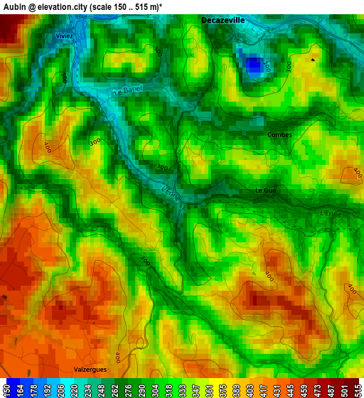
Below is the Elevation map of Aubin, which displays elevation range with different colors. Scale of the first map is from 150 to 515 m (492 to 1690 ft) with average elevation of 336.5 meters (=1104 ft) [note 1]
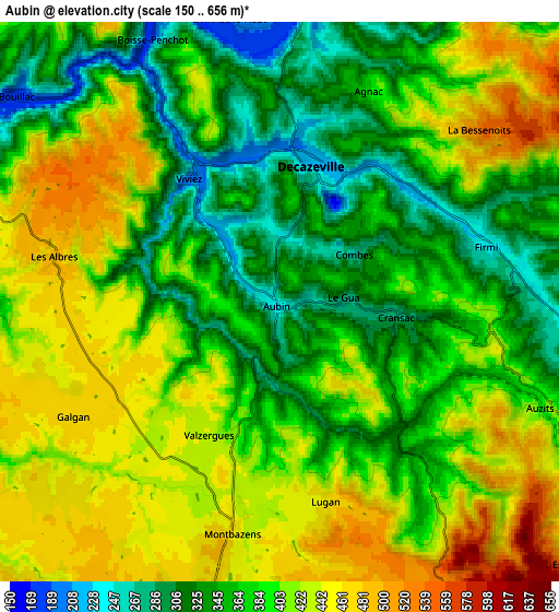
These maps also provides idea of topography and contour of this city, they are displayed at different zoom levels. More info about maps, scale and edge coordinates you can find below images.
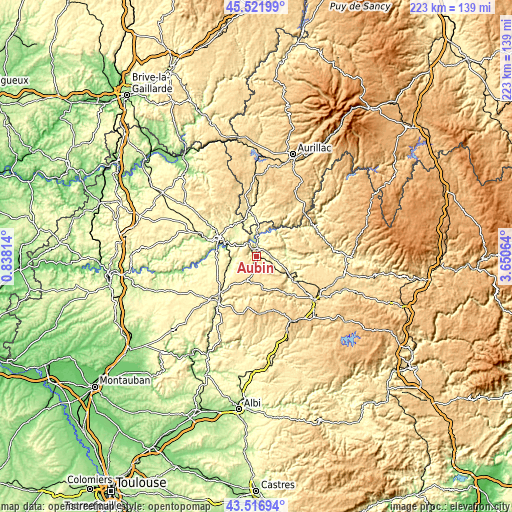
| \ | Map #1 | Map #2 | Topo.Map |
| Scale [m] | 150..515 m | 150..656 m | × |
| Scale [ft] | 492..1690 ft | 492..2152 ft | × |
| Average | 336.5 m = 1104 ft | 389.9 m = 1279 ft | × |
| Width | 6.97 km = 4.3 mi | 13.93 km = 8.7 mi | 222.9 km = 138.5 mi |
| Height | 6.97 km = 4.3 mi | 13.93 km = 8.7 mi | 222.9 km = 138.5 mi |
| ↑Max Latitude | 44.55941° | 44.590714° | 45.52199° |
| Latitude at center | 44.52809° | 44.52809° | 44.52809° |
| ↓Min Latitude | 44.496753° | 44.465398° | 43.51694° |
| ← Min Longitude | 2.200445° | 2.156499° | 0.83814° |
| Longitude center | 2.24439° | 2.24439° | 2.24439° |
| →Max Longitude | 2.288335° | 2.332281° | 3.65064° |
Nearby cities:
Cities around Aubin sort by population:
• Decazeville elevation 211 m
3.6 km,  8°
8°
• Firmi 240 m
5.2 km,  73°
73°
• Rignac 501 m
13.8 km,  164°
164°
• Cransac 285 m
3.1 km,  98°
98°
• Marcillac-Vallon 283 m
18.4 km,  108°
108°
• Viviez 203 m
3.9 km,  325°
325°
• Bagnac-sur-Célé 233 m
16.6 km,  338°
338°
• Montbazens 464 m
5.7 km,  191°
191°
• Valady 327 m
16.6 km,  118°
118°
• Livinhac-le-Haut 217 m
7.2 km,  351°
351°
• Capdenac-Gare 177 m
14 km,  292°
292°
• Saint-Christophe-Vallon 336 m
14.7 km, 115°
Multilingual:
 En español:
Aubin elevación 247 m.
 En France:
Aubin élévation 247 m.


Sources and notes:
- [note 1] Map square and city borders are not equal. Map elevation data is calculated only from area inside that square.
- [src 1] Elevation data from geonames database provided with same terms of usage.
- [src 2] The elevation map of Aubin is generated using elevation data from NASA's 3 arcsec (90m) resolution SRTM data.
- [src 3] Base (background) map © OpenStreetMap contributors tiles are generated by Geofabrik and OpenTopoMap.
Copyright & License:
This Aubin Elevation Map is licensed under CC BY-SA. You may reuse any part from this page, if you give a proper credit by linking to this URL:
 More info on terms of use page.