Capdenac-Gare elevation
Capdenac-Gare (Occitanie, Département de l'Aveyron), France elevation is 177 meters and Capdenac-Gare elevation in feet is 581 ft above sea level [src 1]. Capdenac-Gare is a populated place (feature code) with elevation that is 3 meters (10 ft) bigger than average city elevation in France.
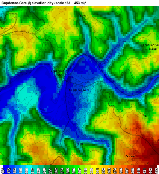
Below is the Elevation map of Capdenac-Gare, which displays elevation range with different colors. Scale of the first map is from 161 to 453 m (528 to 1486 ft) with average elevation of 266.5 meters (=874 ft) [note 1]
These maps also provides idea of topography and contour of this city, they are displayed at different zoom levels. More info about maps, scale and edge coordinates you can find below images.
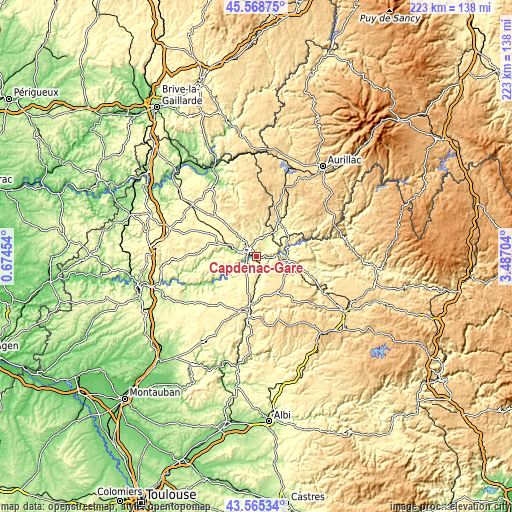
| \ | Map #1 | Topo.Map |
| Scale [m] | 161..453 m | × |
| Scale [ft] | 528..1486 ft | × |
| Average | 266.5 m = 874 ft | × |
| Width | 6.96 km = 4.3 mi | 222.8 km = 138.4 mi |
| Height | 6.96 km = 4.3 mi | 222.7 km = 138.4 mi |
| ↑Max Latitude | 44.606965° | 45.56875° |
| Latitude at center | 44.57567° | 44.57567° |
| ↓Min Latitude | 44.544358° | 43.56534° |
| ← Min Longitude | 2.036845° | 0.67454° |
| Longitude center | 2.08079° | 2.08079° |
| →Max Longitude | 2.124735° | 3.48704° |
Nearby cities:
Cities around Capdenac-Gare sort by population:
• Figeac elevation 230 m
5.3 km,  313°
313°
• Decazeville 211 m
13.6 km,  97°
97°
• Aubin 247 m
14 km,  112°
112°
• Firmi 240 m
18.4 km, 102°
• Maurs 291 m
17.6 km,  31°
31°
• Villeneuve 382 m
16.3 km,  193°
193°
• Cransac 285 m
17.1 km, 109°
• Viviez 203 m
11 km, 101°
• Bagnac-sur-Célé 233 m
12.2 km, 33°
• Montbazens 464 m
16 km,  132°
132°
• Lacapelle-Marival 376 m
20.9 km,  323°
323°
• Livinhac-le-Haut 217 m
12 km,  81°
81°
Multilingual:
 En español:
Capdenac-Gare elevación 177 m.
 En France:
Capdenac-Gare élévation 177 m.
 Auf Deutsch:
Capdenac-Gare höhe über dem Meeresspiegel ist 177 m.

Sources and notes:
- [note 1] Map square and city borders are not equal. Map elevation data is calculated only from area inside that square.
- [src 1] Elevation data from geonames database provided with same terms of usage.
- [src 2] The elevation map of Capdenac-Gare is generated using elevation data from NASA's 3 arcsec (90m) resolution SRTM data.
- [src 3] Base (background) map © OpenStreetMap contributors tiles are generated by Geofabrik and OpenTopoMap.
Copyright & License:
This Capdenac-Gare Elevation Map is licensed under CC BY-SA. You may reuse any part from this page, if you give a proper credit by linking to this URL:
 More info on terms of use page.