Auch elevation
Auch (Occitanie, Gers), France elevation is 136 meters and Auch elevation in feet is 446 ft above sea level [src 1]. Auch is a seat of a second-order administrative division (feature code) with elevation that is 38 meters (125 ft) smaller than average city elevation in France.
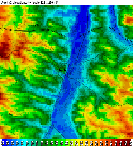
Below is the Elevation map of Auch, which displays elevation range with different colors. Scale of the first map is from 122 to 270 m (400 to 886 ft) with average elevation of 178.6 meters (=586 ft) [note 1]
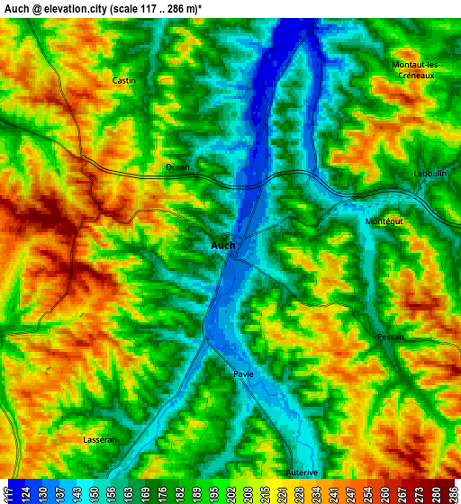
These maps also provides idea of topography and contour of this city, they are displayed at different zoom levels. More info about maps, scale and edge coordinates you can find below images.
| \ | Map #1 | Map #2 | Topo.Map |
| Scale [m] | 122..270 m | 117..286 m | × |
| Scale [ft] | 400..886 ft | 384..938 ft | × |
| Average | 178.6 m = 586 ft | 193.8 m = 636 ft | × |
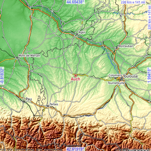
| Width | 7.07 km = 4.4 mi | 14.14 km = 8.8 mi | 226.3 km = 140.6 mi |
| Height | 7.07 km = 4.4 mi | 14.14 km = 8.8 mi | 226.3 km = 140.6 mi |
| ↑Max Latitude | 43.677192° | 43.708966° | 44.65438° |
| Latitude at center | 43.6454° | 43.6454° | 43.6454° |
| ↓Min Latitude | 43.613592° | 43.581766° | 42.61919° |
| ← Min Longitude | 0.543985° | 0.500039° | -0.81832° |
| Longitude center | 0.58793° | 0.58793° | 0.58793° |
| →Max Longitude | 0.631875° | 0.675821° | 1.99418° |
Nearby cities:
Cities around Auch sort by population:
• Fleurance elevation 104 m
23.3 km,  14°
14°
• Mirande 152 m
20.7 km,  225°
225°
• Vic-Fezensac 135 m
26.1 km,  302°
302°
• Gimont 183 m
23.3 km,  95°
95°
• Pavie 143 m
4 km,  175°
175°
• Mauvezin 160 m
25.2 km,  67°
67°
• Masseube 211 m
24 km, 181°
• Valence-sur-Baïse 119 m
31.2 km,  327°
327°
• Jegun 127 m
16.6 km,  324°
324°
• Seissan 189 m
17 km, 178°
• Aubiet 184 m
15.8 km,  89°
89°
• Preignan 136 m
8 km,  22°
22°
Multilingual:
 En español:
Auch elevación 136 m.
 En France:
Auch élévation 136 m.


Sources and notes:
- [note 1] Map square and city borders are not equal. Map elevation data is calculated only from area inside that square.
- [src 1] Elevation data from geonames database provided with same terms of usage.
- [src 2] The elevation map of Auch is generated using elevation data from NASA's 3 arcsec (90m) resolution SRTM data.
- [src 3] Base (background) map © OpenStreetMap contributors tiles are generated by Geofabrik and OpenTopoMap.
Copyright & License:
This Auch Elevation Map is licensed under CC BY-SA. You may reuse any part from this page, if you give a proper credit by linking to this URL:
 More info on terms of use page.