Auvers-le-Hamon elevation
Auvers-le-Hamon (Pays de la Loire, Sarthe), France elevation is 63 meters and Auvers-le-Hamon elevation in feet is 207 ft above sea level [src 1]. Auvers-le-Hamon is a populated place (feature code) with elevation that is 111 meters (364 ft) smaller than average city elevation in France.
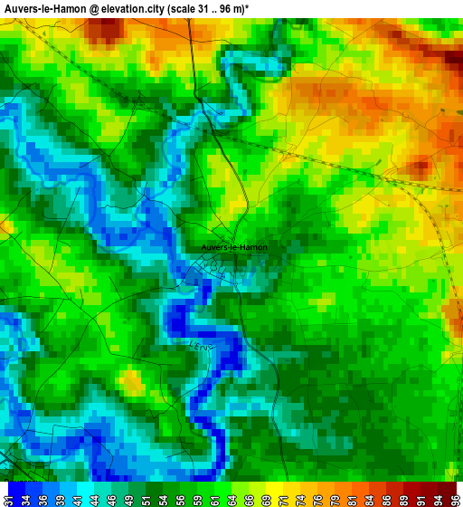
Below is the Elevation map of Auvers-le-Hamon, which displays elevation range with different colors. Scale of the first map is from 31 to 96 m (102 to 315 ft) with average elevation of 57.3 meters (=188 ft) [note 1]
These maps also provides idea of topography and contour of this city, they are displayed at different zoom levels. More info about maps, scale and edge coordinates you can find below images.
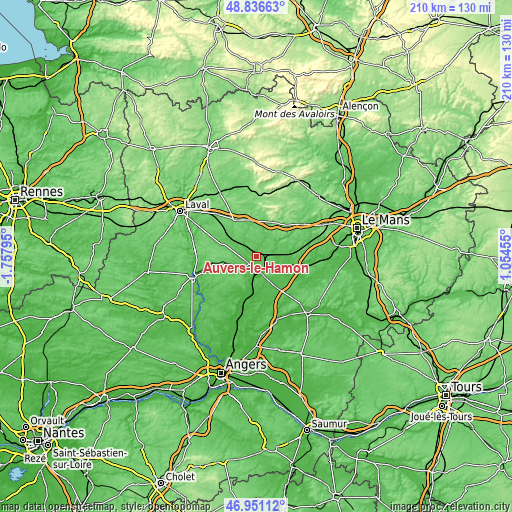
| \ | Map #1 | Topo.Map |
| Scale [m] | 31..96 m | × |
| Scale [ft] | 102..315 ft | × |
| Average | 57.3 m = 188 ft | × |
| Width | 6.55 km = 4.1 mi | 209.6 km = 130.2 mi |
| Height | 6.55 km = 4.1 mi | 209.6 km = 130.2 mi |
| ↑Max Latitude | 47.931912° | 48.83663° |
| Latitude at center | 47.90246° | 47.90246° |
| ↓Min Latitude | 47.872991° | 46.95112° |
| ← Min Longitude | -0.395645° | -1.75795° |
| Longitude center | -0.3517° | -0.3517° |
| →Max Longitude | -0.307755° | 1.05455° |
Nearby cities:
Cities around Auvers-le-Hamon sort by population:
• Sablé-sur-Sarthe elevation 39 m
7.3 km,  169°
169°
• Précigné 36 m
15.2 km, 172°
• Meslay-du-Maine 90 m
16 km,  289°
289°
• Noyen-sur-Sarthe 39 m
19.1 km,  100°
100°
• Loué 77 m
18 km,  54°
54°
• Parcé-sur-Sarthe 44 m
13 km,  120°
120°
• Morannes 28 m
18.3 km,  195°
195°
• Brûlon 103 m
11.3 km, 51°
• Solesmes 48 m
7.1 km,  145°
145°
• Juigné-sur-Sarthe 49 m
6.4 km,  130°
130°
• Vion 48 m
12.5 km,  137°
137°
• Vaiges 99 m
17.9 km,  329°
329°
Multilingual:
 En español:
Auvers-le-Hamon elevación 63 m.
 En France:
Auvers-le-Hamon élévation 63 m.
 Auf Deutsch:
Auvers-le-Hamon höhe über dem Meeresspiegel ist 63 m.

Sources and notes:
- [note 1] Map square and city borders are not equal. Map elevation data is calculated only from area inside that square.
- [src 1] Elevation data from geonames database provided with same terms of usage.
- [src 2] The elevation map of Auvers-le-Hamon is generated using elevation data from NASA's 3 arcsec (90m) resolution SRTM data.
- [src 3] Base (background) map © OpenStreetMap contributors tiles are generated by Geofabrik and OpenTopoMap.
Copyright & License:
This Auvers-le-Hamon Elevation Map is licensed under CC BY-SA. You may reuse any part from this page, if you give a proper credit by linking to this URL:
 More info on terms of use page.