Ay elevation
Ay (Grand Est, Marne), France elevation is 73 meters and Ay elevation in feet is 240 ft above sea level [src 1]. Ay is a populated place (feature code) with elevation that is 101 meters (331 ft) smaller than average city elevation in France.
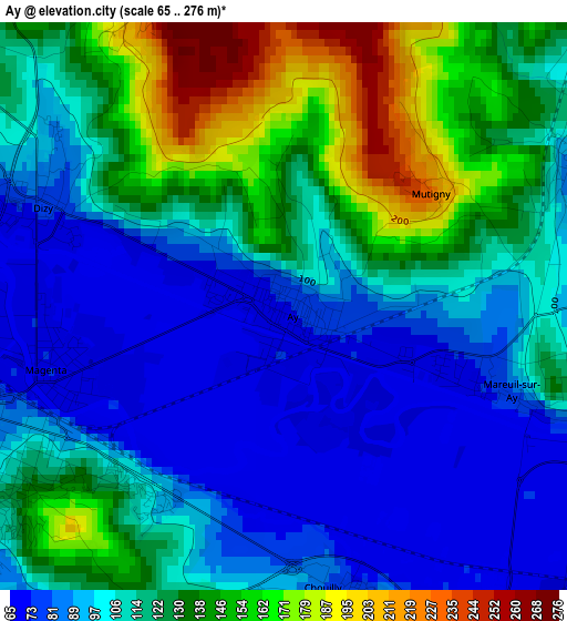
Below is the Elevation map of Ay, which displays elevation range with different colors. Scale of the first map is from 65 to 276 m (213 to 906 ft) with average elevation of 114.3 meters (=375 ft) [note 1]
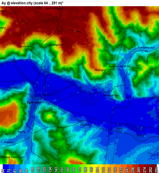
These maps also provides idea of topography and contour of this city, they are displayed at different zoom levels. More info about maps, scale and edge coordinates you can find below images.
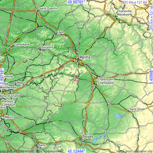
| \ | Map #1 | Map #2 | Topo.Map |
| Scale [m] | 65..276 m | 64..291 m | × |
| Scale [ft] | 213..906 ft | 210..955 ft | × |
| Average | 114.3 m = 375 ft | 141.3 m = 464 ft | × |
| Width | 6.4 km = 4 mi | 12.81 km = 8 mi | 204.9 km = 127.3 mi |
| Height | 6.4 km = 4 mi | 12.81 km = 8 mi | 204.9 km = 127.3 mi |
| ↑Max Latitude | 49.083361° | 49.112135° | 49.96761° |
| Latitude at center | 49.05457° | 49.05457° | 49.05457° |
| ↓Min Latitude | 49.025763° | 48.996938° | 48.12444° |
| ← Min Longitude | 3.959485° | 3.915539° | 2.59718° |
| Longitude center | 4.00343° | 4.00343° | 4.00343° |
| →Max Longitude | 4.047375° | 4.091321° | 5.40968° |
Nearby cities:
Cities around Ay sort by population:
• Épernay elevation 123 m
3.6 km,  243°
243°
• Magenta 70 m
2.6 km,  256°
256°
• Dizy 82 m
3 km,  296°
296°
• Avize 130 m
9 km,  174°
174°
• Mardeuil 76 m
5.4 km,  269°
269°
• Pierry 85 m
6 km,  230°
230°
• Damery 85 m
9.2 km,  282°
282°
• Mareuil-sur-Ay 75 m
2.6 km,  112°
112°
• Tours-sur-Marne 81 m
8.6 km,  94°
94°
• Le Mesnil-sur-Oger 122 m
12 km, 173°
• Rilly-la-Montagne 156 m
12.7 km,  13°
13°
• Verzy 160 m
15.5 km,  49°
49°


Sources and notes:
- [note 1] Map square and city borders are not equal. Map elevation data is calculated only from area inside that square.
- [src 1] Elevation data from geonames database provided with same terms of usage.
- [src 2] The elevation map of Ay is generated using elevation data from NASA's 3 arcsec (90m) resolution SRTM data.
- [src 3] Base (background) map © OpenStreetMap contributors tiles are generated by Geofabrik and OpenTopoMap.
Copyright & License:
This Ay Elevation Map is licensed under CC BY-SA. You may reuse any part from this page, if you give a proper credit by linking to this URL:
 More info on terms of use page.