Épernay elevation
Épernay (Grand Est, Marne), France elevation is 123 meters and Épernay elevation in feet is 404 ft above sea level [src 1]. Épernay is a seat of a third-order administrative division (feature code) with elevation that is 51 meters (167 ft) smaller than average city elevation in France.
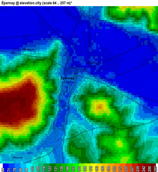
Below is the Elevation map of Épernay, which displays elevation range with different colors. Scale of the first map is from 64 to 257 m (210 to 843 ft) with average elevation of 108.1 meters (=355 ft) [note 1]
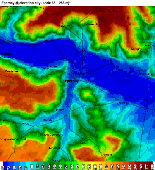
These maps also provides idea of topography and contour of this city, they are displayed at different zoom levels. More info about maps, scale and edge coordinates you can find below images.
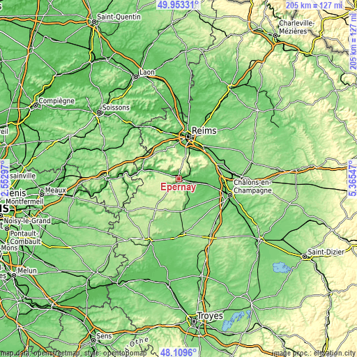
| \ | Map #1 | Map #2 | Topo.Map |
| Scale [m] | 64..257 m | 63..286 m | × |
| Scale [ft] | 210..843 ft | 207..938 ft | × |
| Average | 108.1 m = 355 ft | 145.9 m = 479 ft | × |
| Width | 6.41 km = 4 mi | 12.81 km = 8 mi | 205 km = 127.4 mi |
| Height | 6.41 km = 4 mi | 12.81 km = 8 mi | 205 km = 127.4 mi |
| ↑Max Latitude | 49.068799° | 49.097582° | 49.95331° |
| Latitude at center | 49.04° | 49.04° | 49.04° |
| ↓Min Latitude | 49.011184° | 48.982352° | 48.1096° |
| ← Min Longitude | 3.915275° | 3.871329° | 2.55297° |
| Longitude center | 3.95922° | 3.95922° | 3.95922° |
| →Max Longitude | 4.003165° | 4.047111° | 5.36547° |
Nearby cities:
Cities around Épernay sort by population:
• Ay elevation 73 m
3.6 km,  63°
63°
• Vertus 110 m
15.2 km,  168°
168°
• Magenta 70 m
1.2 km,  34°
34°
• Dizy 82 m
3 km,  10°
10°
• Avize 130 m
8.4 km,  151°
151°
• Mardeuil 76 m
2.6 km,  306°
306°
• Pierry 85 m
2.6 km,  211°
211°
• Damery 85 m
6.8 km,  302°
302°
• Mareuil-le-Port 77 m
15.2 km,  287°
287°
• Mareuil-sur-Ay 75 m
5.6 km,  83°
83°
• Tours-sur-Marne 81 m
11.8 km,  85°
85°
• Le Mesnil-sur-Oger 122 m
11.3 km,  155°
155°
Multilingual:
 En español:
Épernay elevación 123 m.
 En France:
Épernay élévation 123 m.


Sources and notes:
- [note 1] Map square and city borders are not equal. Map elevation data is calculated only from area inside that square.
- [src 1] Elevation data from geonames database provided with same terms of usage.
- [src 2] The elevation map of Épernay is generated using elevation data from NASA's 3 arcsec (90m) resolution SRTM data.
- [src 3] Base (background) map © OpenStreetMap contributors tiles are generated by Geofabrik and OpenTopoMap.
Copyright & License:
This Épernay Elevation Map is licensed under CC BY-SA. You may reuse any part from this page, if you give a proper credit by linking to this URL:
 More info on terms of use page.