Bagnols-sur-Cèze elevation
Bagnols-sur-Cèze (Occitanie, Gard), France elevation is 76 meters and Bagnols-sur-Cèze elevation in feet is 249 ft above sea level [src 1]. Bagnols-sur-Cèze is a populated place (feature code) with elevation that is 98 meters (322 ft) smaller than average city elevation in France.
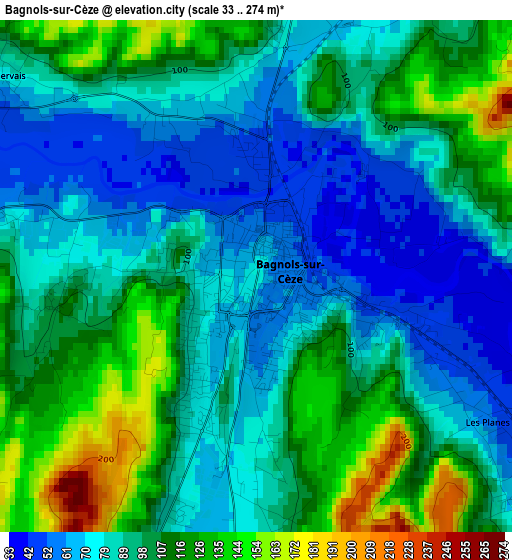
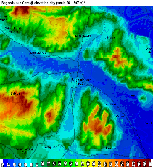
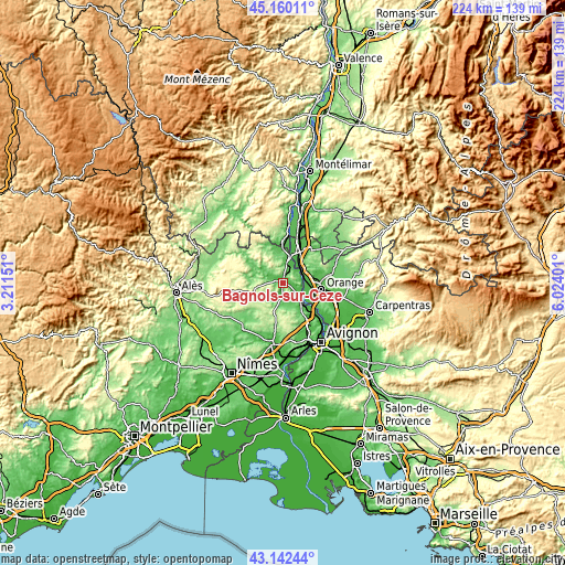
Below is the Elevation map of Bagnols-sur-Cèze, which displays elevation range with different colors. Scale of the first map is from 33 to 274 m (108 to 899 ft) with average elevation of 95.1 meters (=312 ft) [note 1]
These maps also provides idea of topography and contour of this city, they are displayed at different zoom levels. More info about maps, scale and edge coordinates you can find below images.
| \ | Map #1 | Map #2 | Topo.Map |
| Scale [m] | 33..274 m | 26..307 m | × |
| Scale [ft] | 108..899 ft | 85..1007 ft | × |
| Average | 95.1 m = 312 ft | 109.1 m = 358 ft | × |
| Width | 7.01 km = 4.4 mi | 14.02 km = 8.7 mi | 224.3 km = 139.4 mi |
| Height | 7.01 km = 4.4 mi | 14.02 km = 8.7 mi | 224.3 km = 139.4 mi |
| ↑Max Latitude | 44.191418° | 44.222919° | 45.16011° |
| Latitude at center | 44.1599° | 44.1599° | 44.1599° |
| ↓Min Latitude | 44.128365° | 44.096814° | 43.14244° |
| ← Min Longitude | 4.573815° | 4.529869° | 3.21151° |
| Longitude center | 4.61776° | 4.61776° | 4.61776° |
| →Max Longitude | 4.661705° | 4.705651° | 6.02401° |
Nearby cities:
Cities around Bagnols-sur-Cèze sort by population:
• Pont-Saint-Esprit elevation 58 m
10.8 km,  12°
12°
• Laudun-l'Ardoise 47 m
7.7 km,  149°
149°
• Mornas 110 m
10 km,  61°
61°
• Tresques 86 m
6.4 km,  202°
202°
• Sabran 257 m
5.6 km,  259°
259°
• Connaux 87 m
8.1 km,  193°
193°
• Saint-Paulet-de-Caisson 84 m
11.3 km,  351°
351°
• Saint-Victor-la-Coste 124 m
11 km,  169°
169°
• Saint-Nazaire 101 m
4.3 km, 6°
• Vénéjan 79 m
5.1 km,  34°
34°
• Orsan 53 m
5 km,  130°
130°
• Saint-Alexandre 122 m
7.5 km,  1°
1°
Multilingual:
 En español:
Bagnols-sur-Cèze elevación 76 m.
 En France:
Bagnols-sur-Cèze élévation 76 m.
 Auf Deutsch:
Bagnols-sur-Cèze höhe über dem Meeresspiegel ist 76 m.

Sources and notes:
- [note 1] Map square and city borders are not equal. Map elevation data is calculated only from area inside that square.
- [src 1] Elevation data from geonames database provided with same terms of usage.
- [src 2] The elevation map of Bagnols-sur-Cèze is generated using elevation data from NASA's 3 arcsec (90m) resolution SRTM data.
- [src 3] Base (background) map © OpenStreetMap contributors tiles are generated by Geofabrik and OpenTopoMap.
Copyright & License:
This Bagnols-sur-Cèze Elevation Map is licensed under CC BY-SA. You may reuse any part from this page, if you give a proper credit by linking to this URL:
 More info on terms of use page.