Connaux elevation
Connaux (Occitanie, Gard), France elevation is 87 meters and Connaux elevation in feet is 285 ft above sea level [src 1]. Connaux is a populated place (feature code) with elevation that is 87 meters (285 ft) smaller than average city elevation in France.
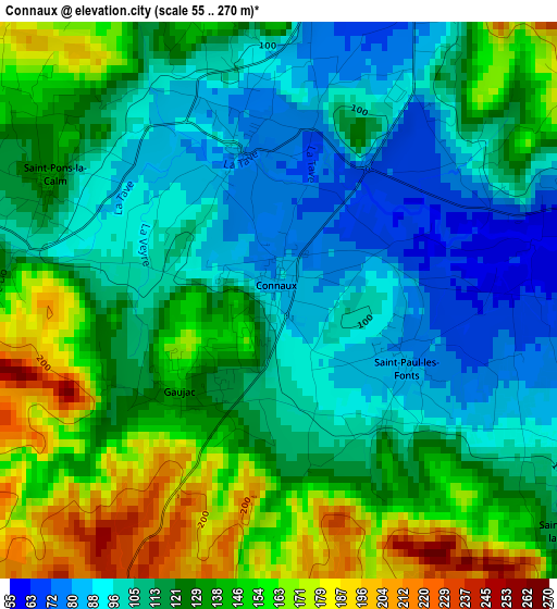
Below is the Elevation map of Connaux, which displays elevation range with different colors. Scale of the first map is from 55 to 270 m (180 to 886 ft) with average elevation of 123.7 meters (=406 ft) [note 1]
These maps also provides idea of topography and contour of this city, they are displayed at different zoom levels. More info about maps, scale and edge coordinates you can find below images.
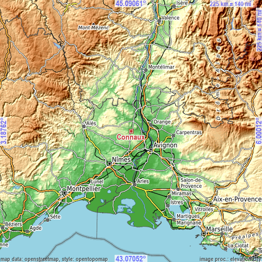
| \ | Map #1 | Topo.Map |
| Scale [m] | 55..270 m | × |
| Scale [ft] | 180..886 ft | × |
| Average | 123.7 m = 406 ft | × |
| Width | 7.02 km = 4.4 mi | 224.6 km = 139.6 mi |
| Height | 7.02 km = 4.4 mi | 224.6 km = 139.6 mi |
| ↑Max Latitude | 44.120746° | 45.09061° |
| Latitude at center | 44.08919° | 44.08919° |
| ↓Min Latitude | 44.057618° | 43.07052° |
| ← Min Longitude | 4.549925° | 3.18762° |
| Longitude center | 4.59387° | 4.59387° |
| →Max Longitude | 4.637815° | 6.00012° |
Nearby cities:
Cities around Connaux sort by population:
• Bagnols-sur-Cèze elevation 76 m
8.1 km,  13°
13°
• Laudun-l'Ardoise 47 m
5.9 km,  78°
78°
• Tresques 86 m
2 km,  345°
345°
• Saint-Laurent-des-Arbres 85 m
9.3 km,  114°
114°
• Sabran 257 m
7.7 km,  331°
331°
• Saint-Geniès-de-Comolas 58 m
10.5 km,  104°
104°
• Tavel 108 m
11.9 km,  135°
135°
• Saint-Victor-la-Coste 124 m
4.9 km,  126°
126°
• Montfaucon 31 m
13 km, 98°
• Saint-Nazaire 101 m
12.4 km, 11°
• Vénéjan 79 m
12.9 km,  21°
21°
• Orsan 53 m
7.4 km,  50°
50°
Multilingual:
 En español:
Connaux elevación 87 m.
 En France:
Connaux élévation 87 m.


Sources and notes:
- [note 1] Map square and city borders are not equal. Map elevation data is calculated only from area inside that square.
- [src 1] Elevation data from geonames database provided with same terms of usage.
- [src 2] The elevation map of Connaux is generated using elevation data from NASA's 3 arcsec (90m) resolution SRTM data.
- [src 3] Base (background) map © OpenStreetMap contributors tiles are generated by Geofabrik and OpenTopoMap.
Copyright & License:
This Connaux Elevation Map is licensed under CC BY-SA. You may reuse any part from this page, if you give a proper credit by linking to this URL:
 More info on terms of use page.