Bailleul-Sir-Berthoult elevation
Bailleul-Sir-Berthoult (Hauts-de-France, Pas-de-Calais), France elevation is 78 meters and Bailleul-Sir-Berthoult elevation in feet is 256 ft above sea level [src 1]. Bailleul-Sir-Berthoult is a populated place (feature code) with elevation that is 96 meters (315 ft) smaller than average city elevation in France.
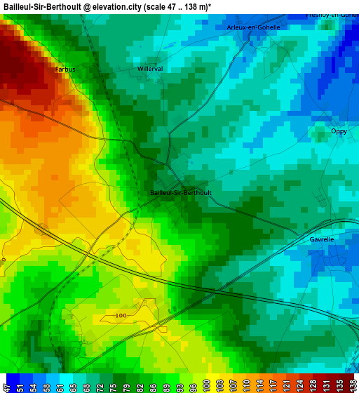
Below is the Elevation map of Bailleul-Sir-Berthoult, which displays elevation range with different colors. Scale of the first map is from 47 to 138 m (154 to 453 ft) with average elevation of 80.6 meters (=264 ft) [note 1]
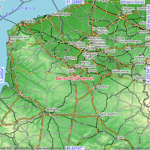
These maps also provides idea of topography and contour of this city, they are displayed at different zoom levels. More info about maps, scale and edge coordinates you can find below images.
| \ | Map #1 | Topo.Map |
| Scale [m] | 47..138 m | × |
| Scale [ft] | 154..453 ft | × |
| Average | 80.6 m = 264 ft | × |
| Width | 6.24 km = 3.9 mi | 199.6 km = 124 mi |
| Height | 6.24 km = 3.9 mi | 199.6 km = 124 mi |
| ↑Max Latitude | 50.36556° | 51.22662° |
| Latitude at center | 50.33752° | 50.33752° |
| ↓Min Latitude | 50.309463° | 49.43147° |
| ← Min Longitude | 2.807345° | 1.44504° |
| Longitude center | 2.85129° | 2.85129° |
| →Max Longitude | 2.895235° | 4.25754° |
Nearby cities:
Cities around Bailleul-Sir-Berthoult sort by population:
• Arras elevation 73 m
7 km,  224°
224°
• Méricourt 52 m
7.1 km,  6°
6°
• Rouvroy 56 m
7.2 km,  31°
31°
• Saint-Nicolas 73 m
6.3 km,  233°
233°
• Saint-Laurent-Blangy 71 m
5.7 km,  213°
213°
• Vimy 77 m
4.8 km,  323°
323°
• Sainte-Catherine 84 m
7 km,  241°
241°
• Neuville-Saint-Vaast 109 m
6.7 km,  289°
289°
• Rœux 48 m
5.9 km,  143°
143°
• Feuchy 56 m
4.8 km,  186°
186°
• Fampoux 51 m
4.3 km,  158°
158°
• Thélus 123 m
4 km,  297°
297°
Multilingual:
 En español:
Bailleul-Sir-Berthoult elevación 78 m.
 En France:
Bailleul-Sir-Berthoult élévation 78 m.
 Auf Deutsch:
Bailleul-Sir-Berthoult höhe über dem Meeresspiegel ist 78 m.
 На русском:
Bailleul-Sir-Berthoult высота над уровнем моря 78 м
Sources and notes:
- [note 1] Map square and city borders are not equal. Map elevation data is calculated only from area inside that square.
- [src 1] Elevation data from geonames database provided with same terms of usage.
- [src 2] The elevation map of Bailleul-Sir-Berthoult is generated using elevation data from NASA's 3 arcsec (90m) resolution SRTM data.
- [src 3] Base (background) map © OpenStreetMap contributors tiles are generated by Geofabrik and OpenTopoMap.
Copyright & License:
This Bailleul-Sir-Berthoult Elevation Map is licensed under CC BY-SA. You may reuse any part from this page, if you give a proper credit by linking to this URL:
 More info on terms of use page.