Barjac elevation
Barjac (Occitanie, Gard), France elevation is 182 meters and Barjac elevation in feet is 597 ft above sea level [src 1]. Barjac is a populated place (feature code) with elevation that is 8 meters (26 ft) bigger than average city elevation in France.
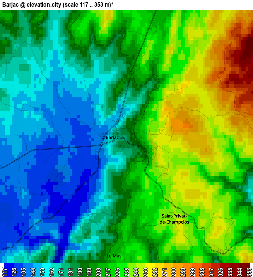
Below is the Elevation map of Barjac, which displays elevation range with different colors. Scale of the first map is from 117 to 353 m (384 to 1158 ft) with average elevation of 202 meters (=663 ft) [note 1]
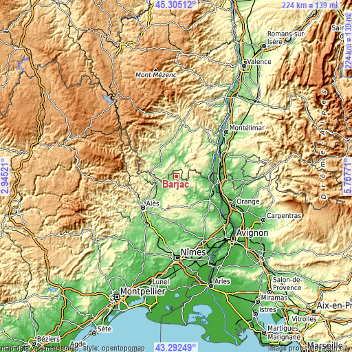
These maps also provides idea of topography and contour of this city, they are displayed at different zoom levels. More info about maps, scale and edge coordinates you can find below images.
| \ | Map #1 | Topo.Map |
| Scale [m] | 117..353 m | × |
| Scale [ft] | 384..1158 ft | × |
| Average | 202 m = 663 ft | × |
| Width | 6.99 km = 4.3 mi | 223.8 km = 139.1 mi |
| Height | 6.99 km = 4.3 mi | 223.8 km = 139.1 mi |
| ↑Max Latitude | 44.338869° | 45.30512° |
| Latitude at center | 44.30743° | 44.30743° |
| ↓Min Latitude | 44.275974° | 43.29249° |
| ← Min Longitude | 4.307515° | 2.94521° |
| Longitude center | 4.35146° | 4.35146° |
| →Max Longitude | 4.395405° | 5.75771° |
Nearby cities:
Cities around Barjac sort by population:
• Saint-Ambroix elevation 149 m
13.3 km,  246°
246°
• Bessèges 176 m
20.4 km,  265°
265°
• Les Vans 185 m
20.6 km,  301°
301°
• Vallon-Pont-d’Arc 135 m
11.6 km,  16°
16°
• Ruoms 122 m
16.2 km,  357°
357°
• Saint-Paulet-de-Caisson 84 m
20.3 km,  104°
104°
• Les Mages 196 m
16.9 km,  238°
238°
• Lablachère 244 m
20.5 km,  327°
327°
• Molières-sur-Cèze 160 m
16.3 km, 251°
• Saint-Florent-sur-Auzonnet 241 m
20.4 km, 248°
• Saint-Julien-de-Peyrolas 106 m
17.1 km, 97°
• Goudargues 84 m
13.9 km,  138°
138°
Multilingual:
 En español:
Barjac elevación 182 m.
 En France:
Barjac élévation 182 m.


Sources and notes:
- [note 1] Map square and city borders are not equal. Map elevation data is calculated only from area inside that square.
- [src 1] Elevation data from geonames database provided with same terms of usage.
- [src 2] The elevation map of Barjac is generated using elevation data from NASA's 3 arcsec (90m) resolution SRTM data.
- [src 3] Base (background) map © OpenStreetMap contributors tiles are generated by Geofabrik and OpenTopoMap.
Copyright & License:
This Barjac Elevation Map is licensed under CC BY-SA. You may reuse any part from this page, if you give a proper credit by linking to this URL:
 More info on terms of use page.