Bessèges elevation
Bessèges (Occitanie, Gard), France elevation is 176 meters and Bessèges elevation in feet is 577 ft above sea level [src 1]. Bessèges is a populated place (feature code) with elevation that is 2 meters (7 ft) bigger than average city elevation in France.
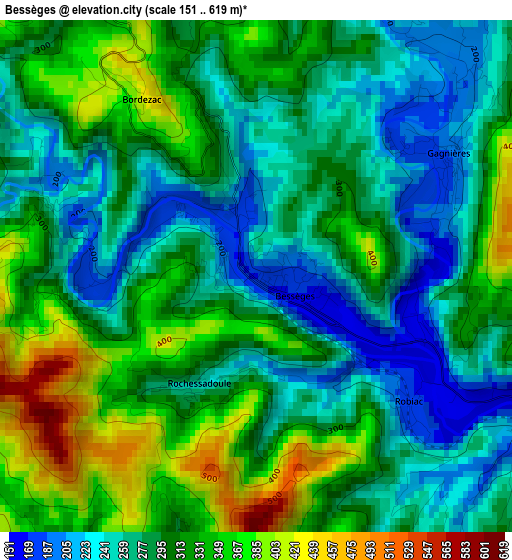
Below is the Elevation map of Bessèges, which displays elevation range with different colors. Scale of the first map is from 151 to 619 m (495 to 2031 ft) with average elevation of 298 meters (=978 ft) [note 1]
These maps also provides idea of topography and contour of this city, they are displayed at different zoom levels. More info about maps, scale and edge coordinates you can find below images.
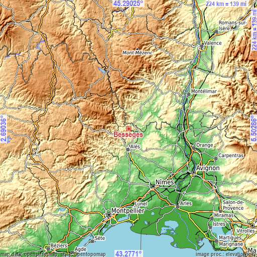
| \ | Map #1 | Topo.Map |
| Scale [m] | 151..619 m | × |
| Scale [ft] | 495..2031 ft | × |
| Average | 298 m = 978 ft | × |
| Width | 6.99 km = 4.3 mi | 223.8 km = 139.1 mi |
| Height | 7 km = 4.3 mi | 223.8 km = 139.1 mi |
| ↑Max Latitude | 44.323747° | 45.29025° |
| Latitude at center | 44.2923° | 44.2923° |
| ↓Min Latitude | 44.260836° | 43.2771° |
| ← Min Longitude | 4.052665° | 2.69036° |
| Longitude center | 4.09661° | 4.09661° |
| →Max Longitude | 4.140555° | 5.50286° |
Nearby cities:
Cities around Bessèges sort by population:
• Saint-Martin-de-Valgalgues elevation 180 m
14.4 km,  184°
184°
• Saint-Ambroix 149 m
8.9 km,  114°
114°
• Salindres 184 m
14.3 km,  159°
159°
• Rousson 224 m
11.9 km, 160°
• Les Salles-du-Gardon 184 m
10.5 km,  206°
206°
• Les Vans 185 m
12.9 km,  12°
12°
• Saint-Julien-les-Rosiers 178 m
13.1 km, 176°
• Les Mages 196 m
9.2 km,  140°
140°
• Molières-sur-Cèze 160 m
6.1 km,  126°
126°
• Branoux-les-Taillades 269 m
11.4 km,  224°
224°
• Saint-Florent-sur-Auzonnet 241 m
5.9 km,  167°
167°
• Laval-Pradel 247 m
9.8 km,  194°
194°
Multilingual:
 En español:
Bessèges elevación 176 m.
 En France:
Bessèges élévation 176 m.
 Auf Deutsch:
Bessèges höhe über dem Meeresspiegel ist 176 m.

Sources and notes:
- [note 1] Map square and city borders are not equal. Map elevation data is calculated only from area inside that square.
- [src 1] Elevation data from geonames database provided with same terms of usage.
- [src 2] The elevation map of Bessèges is generated using elevation data from NASA's 3 arcsec (90m) resolution SRTM data.
- [src 3] Base (background) map © OpenStreetMap contributors tiles are generated by Geofabrik and OpenTopoMap.
Copyright & License:
This Bessèges Elevation Map is licensed under CC BY-SA. You may reuse any part from this page, if you give a proper credit by linking to this URL:
 More info on terms of use page.