Bayeux elevation
Bayeux (Normandy, Calvados), France elevation is 52 meters and Bayeux elevation in feet is 171 ft above sea level [src 1]. Bayeux is a seat of a third-order administrative division (feature code) with elevation that is 122 meters (400 ft) smaller than average city elevation in France.
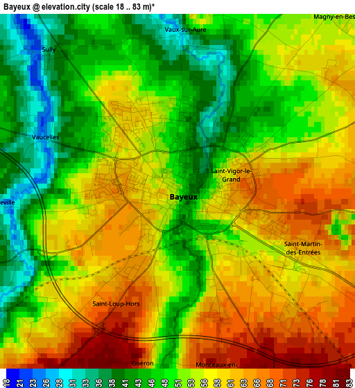
Below is the Elevation map of Bayeux, which displays elevation range with different colors. Scale of the first map is from 18 to 83 m (59 to 272 ft) with average elevation of 53.3 meters (=175 ft) [note 1]
These maps also provides idea of topography and contour of this city, they are displayed at different zoom levels. More info about maps, scale and edge coordinates you can find below images.
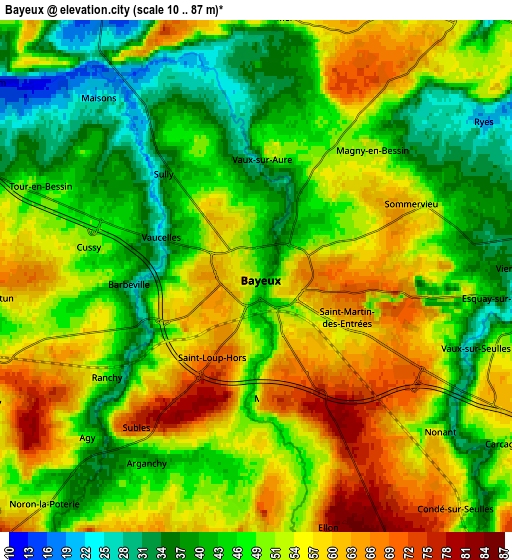
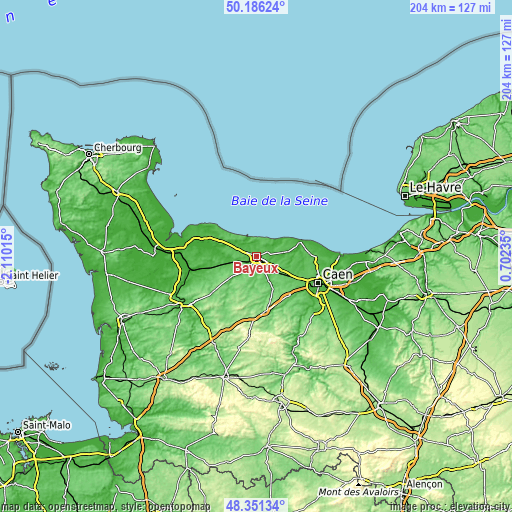
| \ | Map #1 | Map #2 | Topo.Map |
| Scale [m] | 18..83 m | 10..87 m | × |
| Scale [ft] | 59..272 ft | 33..285 ft | × |
| Average | 53.3 m = 175 ft | 50 m = 164 ft | × |
| Width | 6.38 km = 4 mi | 12.75 km = 7.9 mi | 204 km = 126.8 mi |
| Height | 6.38 km = 4 mi | 12.75 km = 7.9 mi | 204 km = 126.8 mi |
| ↑Max Latitude | 49.305982° | 49.334626° | 50.18624° |
| Latitude at center | 49.27732° | 49.27732° | 49.27732° |
| ↓Min Latitude | 49.248642° | 49.219947° | 48.35134° |
| ← Min Longitude | -0.747845° | -0.791791° | -2.11015° |
| Longitude center | -0.7039° | -0.7039° | -0.7039° |
| →Max Longitude | -0.659955° | -0.616009° | 0.70235° |
Nearby cities:
Cities around Bayeux sort by population:
• Le Molay-Littry elevation 44 m
12.8 km,  252°
252°
• Bretteville-l’Orgueilleuse 55 m
15.6 km,  117°
117°
• Port-en-Bessin-Huppain 15 m
8.4 km,  333°
333°
• Saint-Vigor-le-Grand 56 m
1.4 km,  66°
66°
• Saint-Manvieu 78 m
18.2 km,  126°
126°
• Creully 28 m
11.9 km,  86°
86°
• Saint-Manvieu-Norrey 78 m
18.2 km, 125°
• Rots 50 m
18.2 km,  113°
113°
• Thaon 29 m
18.1 km,  96°
96°
• Ver-sur-Mer 32 m
13.8 km,  64°
64°
• Tilly-sur-Seulles 61 m
12.6 km,  153°
153°
• Cheux 82 m
17.9 km, 133°
Multilingual:
 En español:
Bayeux elevación 52 m.
 En France:
Bayeux élévation 52 m.


Sources and notes:
- [note 1] Map square and city borders are not equal. Map elevation data is calculated only from area inside that square.
- [src 1] Elevation data from geonames database provided with same terms of usage.
- [src 2] The elevation map of Bayeux is generated using elevation data from NASA's 3 arcsec (90m) resolution SRTM data.
- [src 3] Base (background) map © OpenStreetMap contributors tiles are generated by Geofabrik and OpenTopoMap.
Copyright & License:
This Bayeux Elevation Map is licensed under CC BY-SA. You may reuse any part from this page, if you give a proper credit by linking to this URL:
 More info on terms of use page.