Bazouges-la-Pérouse elevation
Bazouges-la-Pérouse (Brittany, Département d'Ille-et-Vilaine), France elevation is 105 meters and Bazouges-la-Pérouse elevation in feet is 344 ft above sea level [src 1]. Bazouges-la-Pérouse is a populated place (feature code) with elevation that is 69 meters (226 ft) smaller than average city elevation in France.
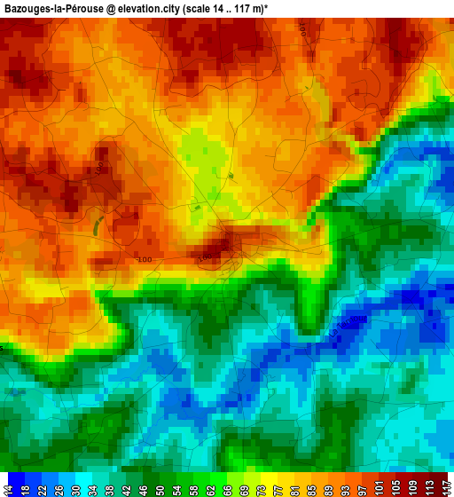
Below is the Elevation map of Bazouges-la-Pérouse, which displays elevation range with different colors. Scale of the first map is from 14 to 117 m (46 to 384 ft) with average elevation of 66.2 meters (=217 ft) [note 1]
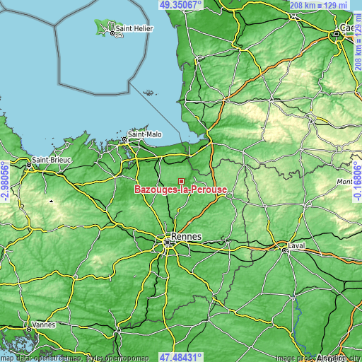
These maps also provides idea of topography and contour of this city, they are displayed at different zoom levels. More info about maps, scale and edge coordinates you can find below images.
| \ | Map #1 | Topo.Map |
| Scale [m] | 14..117 m | × |
| Scale [ft] | 46..384 ft | × |
| Average | 66.2 m = 217 ft | × |
| Width | 6.48 km = 4 mi | 207.5 km = 128.9 mi |
| Height | 6.48 km = 4 mi | 207.5 km = 128.9 mi |
| ↑Max Latitude | 48.455213° | 49.35067° |
| Latitude at center | 48.42606° | 48.42606° |
| ↓Min Latitude | 48.39689° | 47.48431° |
| ← Min Longitude | -1.618255° | -2.98056° |
| Longitude center | -1.57431° | -1.57431° |
| →Max Longitude | -1.530365° | -0.16806° |
Nearby cities:
Cities around Bazouges-la-Pérouse sort by population:
• Combourg elevation 60 m
12.6 km,  263°
263°
• Pontorson 18 m
15 km,  19°
19°
• Sens-de-Bretagne 87 m
10.8 km,  164°
164°
• Pleine-Fougères 39 m
11.9 km,  3°
3°
• Montreuil-sur-Ille 57 m
14.9 km,  207°
207°
• Tremblay 81 m
7.3 km,  93°
93°
• Antrain 37 m
7.7 km,  60°
60°
• Dingé 89 m
12.9 km,  233°
233°
• Bonnemain 71 m
15 km,  287°
287°
• Saint-Marc-le-Blanc 98 m
13.9 km,  119°
119°
• Epiniac 88 m
12.4 km,  311°
311°
• La Boussac 40 m
11.5 km,  326°
326°
Multilingual:
 En español:
Bazouges-la-Pérouse elevación 105 m.
 En France:
Bazouges-la-Pérouse élévation 105 m.
 Auf Deutsch:
Bazouges-la-Pérouse höhe über dem Meeresspiegel ist 105 m.
 На русском:
Bazouges-la-Pérouse высота над уровнем моря 105 м
Sources and notes:
- [note 1] Map square and city borders are not equal. Map elevation data is calculated only from area inside that square.
- [src 1] Elevation data from geonames database provided with same terms of usage.
- [src 2] The elevation map of Bazouges-la-Pérouse is generated using elevation data from NASA's 3 arcsec (90m) resolution SRTM data.
- [src 3] Base (background) map © OpenStreetMap contributors tiles are generated by Geofabrik and OpenTopoMap.
Copyright & License:
This Bazouges-la-Pérouse Elevation Map is licensed under CC BY-SA. You may reuse any part from this page, if you give a proper credit by linking to this URL:
 More info on terms of use page.