Beauchastel elevation
Beauchastel (Auvergne-Rhône-Alpes, Département de l'Ardèche), France elevation is 110 meters and Beauchastel elevation in feet is 361 ft above sea level [src 1]. Beauchastel is a populated place (feature code) with elevation that is 64 meters (210 ft) smaller than average city elevation in France.
Below is the Elevation map of Beauchastel, which displays elevation range with different colors. Scale of the first map is from 89 to 607 m (292 to 1991 ft) with average elevation of 172.5 meters (=566 ft) [note 1]
These maps also provides idea of topography and contour of this city, they are displayed at different zoom levels. More info about maps, scale and edge coordinates you can find below images.
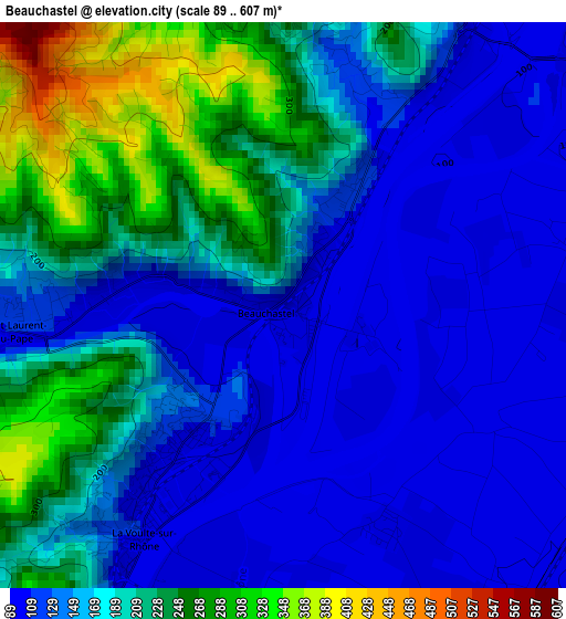
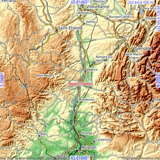
| \ | Map #1 | Topo.Map |
| Scale [m] | 89..607 m | × |
| Scale [ft] | 292..1991 ft | × |
| Average | 172.5 m = 566 ft | × |
| Width | 6.93 km = 4.3 mi | 221.8 km = 137.8 mi |
| Height | 6.93 km = 4.3 mi | 221.8 km = 137.8 mi |
| ↑Max Latitude | 44.85703° | 45.81463° |
| Latitude at center | 44.82587° | 44.82587° |
| ↓Min Latitude | 44.794693° | 43.81986° |
| ← Min Longitude | 4.759105° | 3.3968° |
| Longitude center | 4.80305° | 4.80305° |
| →Max Longitude | 4.846995° | 6.2093° |
Nearby cities:
Cities around Beauchastel sort by population:
• Portes-lès-Valence elevation 120 m
7.9 km,  45°
45°
• Livron-sur-Drôme 124 m
6.2 km,  150°
150°
• Loriol-sur-Drôme 185 m
8.8 km,  172°
172°
• La Voulte-sur-Rhône 93 m
3.5 km,  212°
212°
• Étoile-sur-Rhône 180 m
7 km,  78°
78°
• Le Pouzin 94 m
9.3 km, 207°
• Charmes-sur-Rhône 111 m
4.9 km,  31°
31°
• Saint-Georges-les-Bains 182 m
3.9 km,  7°
7°
• Soyons 112 m
8 km, 27°
• Beauvallon 141 m
8.9 km,  67°
67°
• Toulaud 219 m
8.1 km, 7°
• Saint-Laurent-du-Pape 160 m
2.9 km,  264°
264°
Multilingual:
 En español:
Beauchastel elevación 110 m.
 En France:
Beauchastel élévation 110 m.
 Auf Deutsch:
Beauchastel höhe über dem Meeresspiegel ist 110 m.

Sources and notes:
- [note 1] Map square and city borders are not equal. Map elevation data is calculated only from area inside that square.
- [src 1] Elevation data from geonames database provided with same terms of usage.
- [src 2] The elevation map of Beauchastel is generated using elevation data from NASA's 3 arcsec (90m) resolution SRTM data.
- [src 3] Base (background) map © OpenStreetMap contributors tiles are generated by Geofabrik and OpenTopoMap.
Copyright & License:
This Beauchastel Elevation Map is licensed under CC BY-SA. You may reuse any part from this page, if you give a proper credit by linking to this URL:
 More info on terms of use page.