Beaune-la-Rolande elevation
Beaune-la-Rolande (Centre, Loiret), France elevation is 106 meters and Beaune-la-Rolande elevation in feet is 348 ft above sea level [src 1]. Beaune-la-Rolande is a populated place (feature code) with elevation that is 68 meters (223 ft) smaller than average city elevation in France.
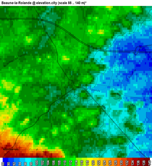
Below is the Elevation map of Beaune-la-Rolande, which displays elevation range with different colors. Scale of the first map is from 88 to 140 m (289 to 459 ft) with average elevation of 104.8 meters (=344 ft) [note 1]
These maps also provides idea of topography and contour of this city, they are displayed at different zoom levels. More info about maps, scale and edge coordinates you can find below images.
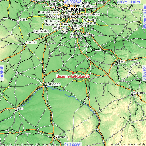
| \ | Map #1 | Topo.Map |
| Scale [m] | 88..140 m | × |
| Scale [ft] | 289..459 ft | × |
| Average | 104.8 m = 344 ft | × |
| Width | 6.53 km = 4.1 mi | 209 km = 129.9 mi |
| Height | 6.53 km = 4.1 mi | 209 km = 129.9 mi |
| ↑Max Latitude | 48.100596° | 49.00234° |
| Latitude at center | 48.07124° | 48.07124° |
| ↓Min Latitude | 48.041867° | 47.12299° |
| ← Min Longitude | 2.387455° | 1.02515° |
| Longitude center | 2.4314° | 2.4314° |
| →Max Longitude | 2.475345° | 3.83765° |
Nearby cities:
Cities around Beaune-la-Rolande sort by population:
• Pithiviers elevation 106 m
17.4 km,  310°
310°
• Pannes 91 m
18.5 km,  108°
108°
• Dadonville 116 m
15.3 km, 309°
• Bellegarde 122 m
9.8 km,  179°
179°
• Corbeilles 85 m
8.8 km,  89°
89°
• Ladon 98 m
11 km,  134°
134°
• Chevillon-sur-Huillard 99 m
18.9 km, 130°
• Boiscommun 137 m
5.3 km,  222°
222°
• Boynes 112 m
7.4 km, 314°
• Saint-Maurice-sur-Fessard 89 m
16.6 km,  121°
121°
• Beaumont-du-Gâtinais 88 m
8.3 km,  25°
25°
• Quiers-sur-Bézonde 112 m
8.4 km,  174°
174°
Multilingual:
 En español:
Beaune-la-Rolande elevación 106 m.
 En France:
Beaune-la-Rolande élévation 106 m.
 Auf Deutsch:
Beaune-la-Rolande höhe über dem Meeresspiegel ist 106 m.

Sources and notes:
- [note 1] Map square and city borders are not equal. Map elevation data is calculated only from area inside that square.
- [src 1] Elevation data from geonames database provided with same terms of usage.
- [src 2] The elevation map of Beaune-la-Rolande is generated using elevation data from NASA's 3 arcsec (90m) resolution SRTM data.
- [src 3] Base (background) map © OpenStreetMap contributors tiles are generated by Geofabrik and OpenTopoMap.
Copyright & License:
This Beaune-la-Rolande Elevation Map is licensed under CC BY-SA. You may reuse any part from this page, if you give a proper credit by linking to this URL:
 More info on terms of use page.