Bethoncourt elevation
Bethoncourt (Bourgogne-Franche-Comté, Doubs), France elevation is 361 meters and Bethoncourt elevation in feet is 1184 ft above sea level [src 1]. Bethoncourt is a populated place (feature code) with elevation that is 187 meters (614 ft) bigger than average city elevation in France.
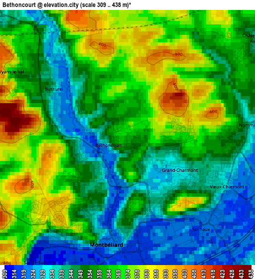
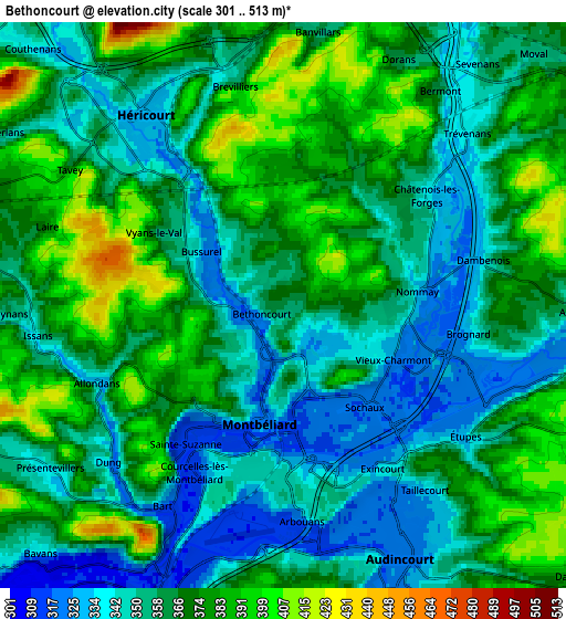
Below is the Elevation map of Bethoncourt, which displays elevation range with different colors. Scale of the first map is from 309 to 438 m (1014 to 1437 ft) with average elevation of 357.2 meters (=1172 ft) [note 1]
These maps also provides idea of topography and contour of this city, they are displayed at different zoom levels. More info about maps, scale and edge coordinates you can find below images.
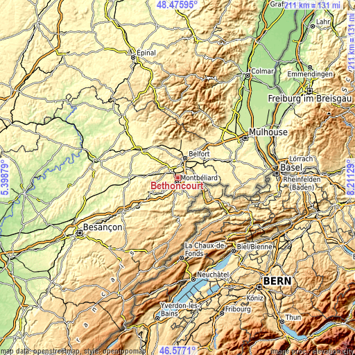
| \ | Map #1 | Map #2 | Topo.Map |
| Scale [m] | 309..438 m | 301..513 m | × |
| Scale [ft] | 1014..1437 ft | 988..1683 ft | × |
| Average | 357.2 m = 1172 ft | 363 m = 1191 ft | × |
| Width | 6.6 km = 4.1 mi | 13.2 km = 8.2 mi | 211.1 km = 131.2 mi |
| Height | 6.6 km = 4.1 mi | 13.2 km = 8.2 mi | 211.1 km = 131.2 mi |
| ↑Max Latitude | 47.564781° | 47.594425° | 48.47595° |
| Latitude at center | 47.53512° | 47.53512° | 47.53512° |
| ↓Min Latitude | 47.505442° | 47.475748° | 46.5771° |
| ← Min Longitude | 6.761095° | 6.717149° | 5.39879° |
| Longitude center | 6.80504° | 6.80504° | 6.80504° |
| →Max Longitude | 6.848985° | 6.892931° | 8.21129° |
Nearby cities:
Cities around Bethoncourt sort by population:
• Montbéliard elevation 321 m
2.9 km,  190°
190°
• Héricourt 329 m
5.3 km,  322°
322°
• Grand-Charmont 335 m
1.8 km,  120°
120°
• Sochaux 324 m
3.4 km,  150°
150°
• Exincourt 320 m
4.9 km,  156°
156°
• Châtenois-les-Forges 332 m
4.2 km,  51°
51°
• Vieux-Charmont 320 m
2.8 km, 121°
• Nommay 355 m
2.8 km,  83°
83°
• Sainte-Suzanne 407 m
4.8 km,  215°
215°
• Courcelles-lès-Montbéliard 341 m
4.1 km,  202°
202°
• Taillecourt 339 m
5.8 km,  140°
140°
• Arbouans 347 m
4 km, 190°
Multilingual:
 En español:
Bethoncourt elevación 361 m.
 En France:
Bethoncourt élévation 361 m.
 Auf Deutsch:
Bethoncourt höhe über dem Meeresspiegel ist 361 m.

Sources and notes:
- [note 1] Map square and city borders are not equal. Map elevation data is calculated only from area inside that square.
- [src 1] Elevation data from geonames database provided with same terms of usage.
- [src 2] The elevation map of Bethoncourt is generated using elevation data from NASA's 3 arcsec (90m) resolution SRTM data.
- [src 3] Base (background) map © OpenStreetMap contributors tiles are generated by Geofabrik and OpenTopoMap.
Copyright & License:
This Bethoncourt Elevation Map is licensed under CC BY-SA. You may reuse any part from this page, if you give a proper credit by linking to this URL:
 More info on terms of use page.