Héricourt elevation
Héricourt (Bourgogne-Franche-Comté, Département de la Haute-Saône), France elevation is 329 meters and Héricourt elevation in feet is 1079 ft above sea level [src 1]. Héricourt is a populated place (feature code) with elevation that is 155 meters (509 ft) bigger than average city elevation in France.
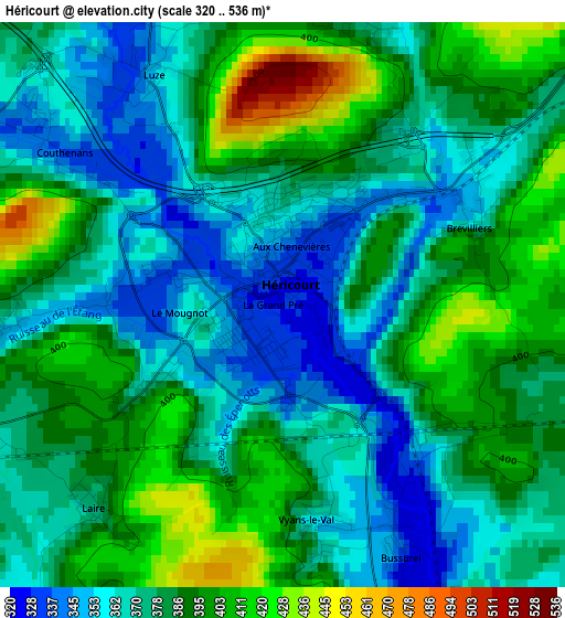
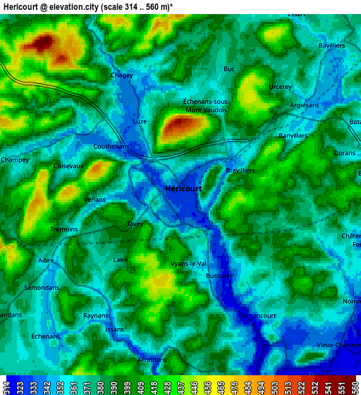
Below is the Elevation map of Héricourt, which displays elevation range with different colors. Scale of the first map is from 320 to 536 m (1050 to 1759 ft) with average elevation of 380.3 meters (=1248 ft) [note 1]
These maps also provides idea of topography and contour of this city, they are displayed at different zoom levels. More info about maps, scale and edge coordinates you can find below images.
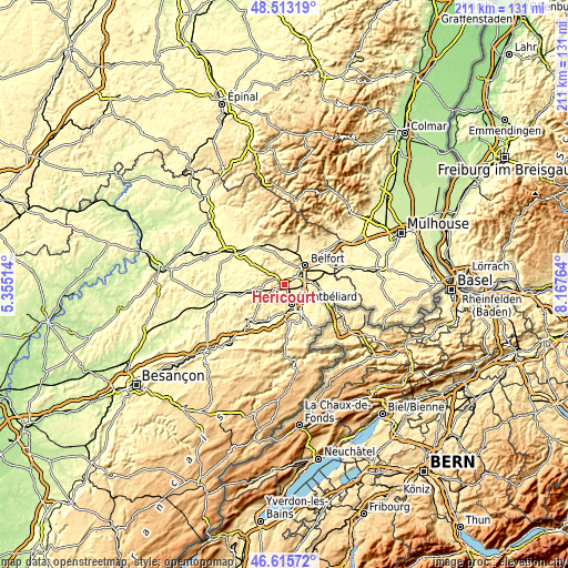
| \ | Map #1 | Map #2 | Topo.Map |
| Scale [m] | 320..536 m | 314..560 m | × |
| Scale [ft] | 1050..1759 ft | 1030..1837 ft | × |
| Average | 380.3 m = 1248 ft | 383.7 m = 1259 ft | × |
| Width | 6.59 km = 4.1 mi | 13.19 km = 8.2 mi | 211 km = 131.1 mi |
| Height | 6.59 km = 4.1 mi | 13.19 km = 8.2 mi | 211 km = 131.1 mi |
| ↑Max Latitude | 47.602689° | 47.632312° | 48.51319° |
| Latitude at center | 47.57305° | 47.57305° | 47.57305° |
| ↓Min Latitude | 47.543394° | 47.513721° | 46.61572° |
| ← Min Longitude | 6.717445° | 6.673499° | 5.35514° |
| Longitude center | 6.76139° | 6.76139° | 6.76139° |
| →Max Longitude | 6.805335° | 6.849281° | 8.16764° |
Nearby cities:
Cities around Héricourt sort by population:
• Montbéliard elevation 321 m
7.6 km,  158°
158°
• Bethoncourt 361 m
5.3 km,  142°
142°
• Grand-Charmont 335 m
7.1 km, 136°
• Bavilliers 361 m
7.8 km,  45°
45°
• Essert 394 m
7.9 km,  31°
31°
• Châtenois-les-Forges 332 m
6.7 km,  103°
103°
• Vieux-Charmont 320 m
8.1 km,  134°
134°
• Nommay 355 m
7.2 km,  122°
122°
• Sainte-Suzanne 407 m
8.1 km,  176°
176°
• Andelnans 347 m
8.5 km,  67°
67°
• Châlonvillars 375 m
7.7 km,  12°
12°
• Courcelles-lès-Montbéliard 341 m
8.2 km,  167°
167°
Multilingual:
 En español:
Héricourt elevación 329 m.
 En France:
Héricourt élévation 329 m.
 Auf Deutsch:
Héricourt höhe über dem Meeresspiegel ist 329 m.

Sources and notes:
- [note 1] Map square and city borders are not equal. Map elevation data is calculated only from area inside that square.
- [src 1] Elevation data from geonames database provided with same terms of usage.
- [src 2] The elevation map of Héricourt is generated using elevation data from NASA's 3 arcsec (90m) resolution SRTM data.
- [src 3] Base (background) map © OpenStreetMap contributors tiles are generated by Geofabrik and OpenTopoMap.
Copyright & License:
This Héricourt Elevation Map is licensed under CC BY-SA. You may reuse any part from this page, if you give a proper credit by linking to this URL:
 More info on terms of use page.