la Guingueta d'Ix elevation
la Guingueta d'Ix (Occitanie, Département des Pyrénées-Orientales), France elevation is 1143 meters and la Guingueta d'Ix elevation in feet is 3750 ft above sea level [src 1]. la Guingueta d'Ix is a populated place (feature code) with elevation that is 969 meters (3179 ft) bigger than average city elevation in France.
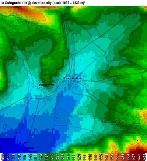
Below is the Elevation map of la Guingueta d'Ix, which displays elevation range with different colors. Scale of the first map is from 1092 to 1433 m (3583 to 4701 ft) with average elevation of 1188.8 meters (=3900 ft) [note 1]
These maps also provides idea of topography and contour of this city, they are displayed at different zoom levels. More info about maps, scale and edge coordinates you can find below images.
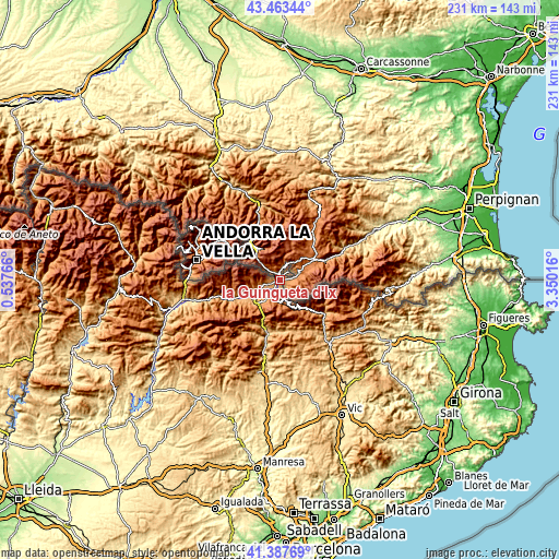
| \ | Map #1 | Topo.Map |
| Scale [m] | 1092..1433 m | × |
| Scale [ft] | 3583..4701 ft | × |
| Average | 1188.8 m = 3900 ft | × |
| Width | 7.21 km = 4.5 mi | 230.8 km = 143.4 mi |
| Height | 7.21 km = 4.5 mi | 230.8 km = 143.4 mi |
| ↑Max Latitude | 42.466586° | 43.46344° |
| Latitude at center | 42.43416° | 42.43416° |
| ↓Min Latitude | 42.401718° | 41.38769° |
| ← Min Longitude | 1.899965° | 0.53766° |
| Longitude center | 1.94391° | 1.94391° |
| →Max Longitude | 1.987855° | 3.35016° |
Nearby cities:
Cities around la Guingueta d'Ix sort by population:
• Prades elevation 343 m
44.2 km,  62°
62°
• Quillan 291 m
52.8 km,  21°
21°
• Tarascon-sur-Ariège 478 m
53.5 km,  328°
328°
• Font-Romeu-Odeillo-Via 1776 m
11.2 km,  44°
44°
• Vinça 270 m
53.3 km, 63°
• Osséja 1251 m
3.9 km,  125°
125°
• Ax-les-Thermes 722 m
32.9 km,  344°
344°
• Vernet-les-Bains 657 m
38.5 km,  70°
70°
• Ria-Sirach 459 m
42.5 km, 61°
• Bélesta 500 m
52.1 km,  359°
359°
• Prats de Molló 752 m
44.1 km,  94°
94°
• Villeneuve-d’Olmes 609 m
53.5 km,  349°
349°
Multilingual:
 En español:
la Guingueta d'Ix elevación 1143 m.
 En France:
Bourg-Madame élévation 1143 m.
 Auf Deutsch:
la Guingueta d'Ix höhe über dem Meeresspiegel ist 1143 m.

Sources and notes:
- [note 1] Map square and city borders are not equal. Map elevation data is calculated only from area inside that square.
- [src 1] Elevation data from geonames database provided with same terms of usage.
- [src 2] The elevation map of la Guingueta d'Ix is generated using elevation data from NASA's 3 arcsec (90m) resolution SRTM data.
- [src 3] Base (background) map © OpenStreetMap contributors tiles are generated by Geofabrik and OpenTopoMap.
Copyright & License:
This la Guingueta d'Ix Elevation Map is licensed under CC BY-SA. You may reuse any part from this page, if you give a proper credit by linking to this URL:
 More info on terms of use page.