Bouxières-aux-Chênes elevation
Bouxières-aux-Chênes (Grand Est, Meurthe-et-Moselle), France elevation is 261 meters and Bouxières-aux-Chênes elevation in feet is 856 ft above sea level [src 1]. Bouxières-aux-Chênes is a populated place (feature code) with elevation that is 87 meters (285 ft) bigger than average city elevation in France.
Below is the Elevation map of Bouxières-aux-Chênes, which displays elevation range with different colors. Scale of the first map is from 201 to 414 m (659 to 1358 ft) with average elevation of 297 meters (=974 ft) [note 1]
These maps also provides idea of topography and contour of this city, they are displayed at different zoom levels. More info about maps, scale and edge coordinates you can find below images.
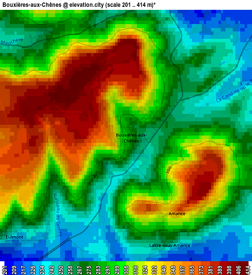
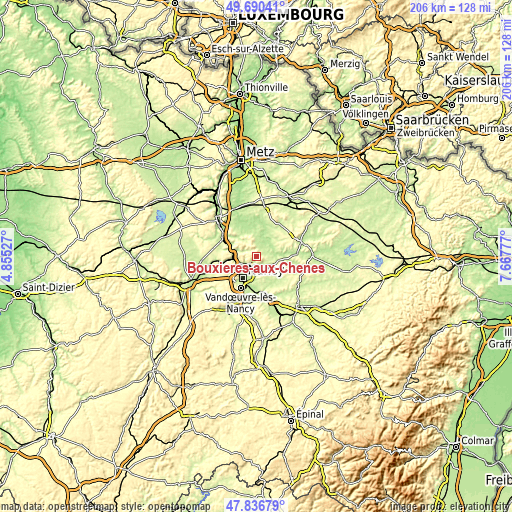
| \ | Map #1 | Topo.Map |
| Scale [m] | 201..414 m | × |
| Scale [ft] | 659..1358 ft | × |
| Average | 297 m = 974 ft | × |
| Width | 6.44 km = 4 mi | 206.1 km = 128.1 mi |
| Height | 6.44 km = 4 mi | 206.1 km = 128.1 mi |
| ↑Max Latitude | 48.801104° | 49.69041° |
| Latitude at center | 48.77215° | 48.77215° |
| ↓Min Latitude | 48.743179° | 47.83679° |
| ← Min Longitude | 6.217575° | 4.85527° |
| Longitude center | 6.26152° | 6.26152° |
| →Max Longitude | 6.305465° | 7.66777° |
Nearby cities:
Cities around Bouxières-aux-Chênes sort by population:
• Saint-Max elevation 207 m
8.5 km,  207°
207°
• Malzéville 272 m
8.7 km,  220°
220°
• Essey-lès-Nancy 212 m
7.9 km,  198°
198°
• Champigneulles 193 m
8.4 km,  239°
239°
• Seichamps 244 m
6.4 km,  180°
180°
• Pulnoy 222 m
7.6 km, 182°
• Bouxières-aux-Dames 263 m
7.5 km,  254°
254°
• Custines 271 m
8.8 km,  283°
283°
• Lay-Saint-Christophe 202 m
5.3 km, 241°
• Faulx 258 m
5.3 km,  295°
295°
• Champenoux 237 m
7.2 km,  117°
117°
• Eulmont 246 m
3.5 km,  225°
225°
Multilingual:
 En español:
Bouxières-aux-Chênes elevación 261 m.
 En France:
Bouxières-aux-Chênes élévation 261 m.
 Auf Deutsch:
Bouxières-aux-Chênes höhe über dem Meeresspiegel ist 261 m.

Sources and notes:
- [note 1] Map square and city borders are not equal. Map elevation data is calculated only from area inside that square.
- [src 1] Elevation data from geonames database provided with same terms of usage.
- [src 2] The elevation map of Bouxières-aux-Chênes is generated using elevation data from NASA's 3 arcsec (90m) resolution SRTM data.
- [src 3] Base (background) map © OpenStreetMap contributors tiles are generated by Geofabrik and OpenTopoMap.
Copyright & License:
This Bouxières-aux-Chênes Elevation Map is licensed under CC BY-SA. You may reuse any part from this page, if you give a proper credit by linking to this URL:
 More info on terms of use page.