Bully elevation
Bully (Auvergne-Rhône-Alpes, Département du Rhône), France elevation is 318 meters and Bully elevation in feet is 1043 ft above sea level [src 1]. Bully is a populated place (feature code) with elevation that is 144 meters (472 ft) bigger than average city elevation in France.
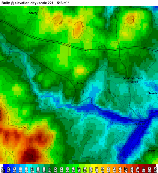
Below is the Elevation map of Bully, which displays elevation range with different colors. Scale of the first map is from 221 to 513 m (725 to 1683 ft) with average elevation of 328.8 meters (=1079 ft) [note 1]
These maps also provides idea of topography and contour of this city, they are displayed at different zoom levels. More info about maps, scale and edge coordinates you can find below images.
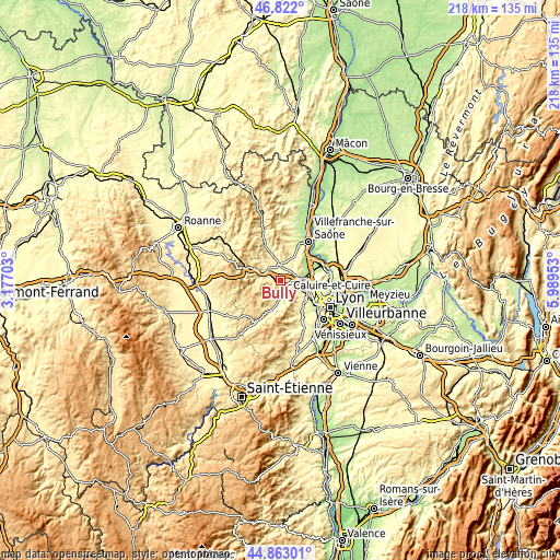
| \ | Map #1 | Topo.Map |
| Scale [m] | 221..513 m | × |
| Scale [ft] | 725..1683 ft | × |
| Average | 328.8 m = 1079 ft | × |
| Width | 6.81 km = 4.2 mi | 217.8 km = 135.3 mi |
| Height | 6.81 km = 4.2 mi | 217.8 km = 135.3 mi |
| ↑Max Latitude | 45.881731° | 46.822° |
| Latitude at center | 45.85113° | 45.85113° |
| ↓Min Latitude | 45.820513° | 44.86301° |
| ← Min Longitude | 4.539335° | 3.17703° |
| Longitude center | 4.58328° | 4.58328° |
| →Max Longitude | 4.627225° | 5.98953° |
Nearby cities:
Cities around Bully sort by population:
• Lentilly elevation 307 m
7.2 km,  120°
120°
• Lozanne 207 m
7.6 km,  84°
84°
• Pontcharra-sur-Turdine 361 m
7.7 km,  289°
289°
• Le Bois-d'Oingt 354 m
7.3 km,  359°
359°
• Saint-Pierre-la-Palud 423 m
7 km,  161°
161°
• Savigny 284 m
4 km,  190°
190°
• Sain-Bel 251 m
4.7 km,  165°
165°
• Châtillon 298 m
5.6 km,  58°
58°
• Sourcieux-les-Mines 403 m
5.9 km,  148°
148°
• Chessy 222 m
5.1 km,  37°
37°
• Saint-Romain-de-Popey 411 m
4.1 km,  263°
263°
• Saint-Germain-Nuelles 302 m
2.2 km,  86°
86°
Multilingual:
 En español:
Bully elevación 318 m.
 En France:
Bully élévation 318 m.


Sources and notes:
- [note 1] Map square and city borders are not equal. Map elevation data is calculated only from area inside that square.
- [src 1] Elevation data from geonames database provided with same terms of usage.
- [src 2] The elevation map of Bully is generated using elevation data from NASA's 3 arcsec (90m) resolution SRTM data.
- [src 3] Base (background) map © OpenStreetMap contributors tiles are generated by Geofabrik and OpenTopoMap.
Copyright & License:
This Bully Elevation Map is licensed under CC BY-SA. You may reuse any part from this page, if you give a proper credit by linking to this URL:
 More info on terms of use page.