Bussières elevation
Bussières (Auvergne-Rhône-Alpes, Département de la Loire), France elevation is 665 meters and Bussières elevation in feet is 2182 ft above sea level [src 1]. Bussières is a populated place (feature code) with elevation that is 491 meters (1611 ft) bigger than average city elevation in France.
Below is the Elevation map of Bussières, which displays elevation range with different colors. Scale of the first map is from 375 to 771 m (1230 to 2530 ft) with average elevation of 571.3 meters (=1874 ft) [note 1]
These maps also provides idea of topography and contour of this city, they are displayed at different zoom levels. More info about maps, scale and edge coordinates you can find below images.
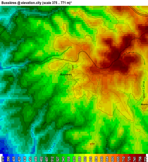
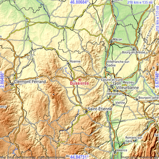
| \ | Map #1 | Topo.Map |
| Scale [m] | 375..771 m | × |
| Scale [ft] | 1230..2530 ft | × |
| Average | 571.3 m = 1874 ft | × |
| Width | 6.81 km = 4.2 mi | 217.9 km = 135.4 mi |
| Height | 6.81 km = 4.2 mi | 217.9 km = 135.4 mi |
| ↑Max Latitude | 45.866309° | 46.80684° |
| Latitude at center | 45.8357° | 45.8357° |
| ↓Min Latitude | 45.805074° | 44.84731° |
| ← Min Longitude | 4.227285° | 2.86498° |
| Longitude center | 4.27123° | 4.27123° |
| →Max Longitude | 4.315175° | 5.67748° |
Nearby cities:
Cities around Bussières sort by population:
• Tarare elevation 402 m
14.2 km,  61°
61°
• Feurs 350 m
11.9 km,  196°
196°
• Amplepuis 462 m
15.9 km,  16°
16°
• Panissières 606 m
7.3 km,  131°
131°
• Balbigny 345 m
6.5 km,  253°
253°
• Saint-Symphorien-de-Lay 442 m
13.2 km,  340°
340°
• Saint-Just-la-Pendue 561 m
6.9 km, 340°
• Violay 879 m
7.1 km,  73°
73°
• Rozier-en-Donzy 501 m
3.9 km,  173°
173°
• Neulise 545 m
9.8 km,  314°
314°
• Civens 383 m
6.4 km,  193°
193°
• Pouilly-lès-Feurs 370 m
5.2 km,  215°
215°
Multilingual:
 En español:
Bussières elevación 665 m.
 En France:
Bussières élévation 665 m.
 Auf Deutsch:
Bussières höhe über dem Meeresspiegel ist 665 m.

Sources and notes:
- [note 1] Map square and city borders are not equal. Map elevation data is calculated only from area inside that square.
- [src 1] Elevation data from geonames database provided with same terms of usage.
- [src 2] The elevation map of Bussières is generated using elevation data from NASA's 3 arcsec (90m) resolution SRTM data.
- [src 3] Base (background) map © OpenStreetMap contributors tiles are generated by Geofabrik and OpenTopoMap.
Copyright & License:
This Bussières Elevation Map is licensed under CC BY-SA. You may reuse any part from this page, if you give a proper credit by linking to this URL:
 More info on terms of use page.