Civens elevation
Civens (Auvergne-Rhône-Alpes, Département de la Loire), France elevation is 383 meters and Civens elevation in feet is 1257 ft above sea level [src 1]. Civens is a populated place (feature code) with elevation that is 209 meters (686 ft) bigger than average city elevation in France.
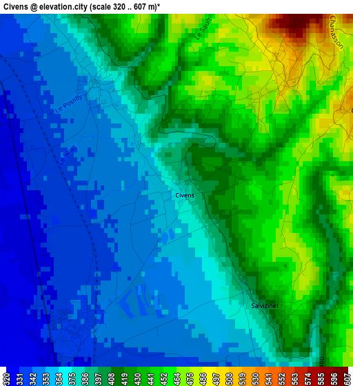
Below is the Elevation map of Civens, which displays elevation range with different colors. Scale of the first map is from 320 to 607 m (1050 to 1991 ft) with average elevation of 394.7 meters (=1295 ft) [note 1]
These maps also provides idea of topography and contour of this city, they are displayed at different zoom levels. More info about maps, scale and edge coordinates you can find below images.
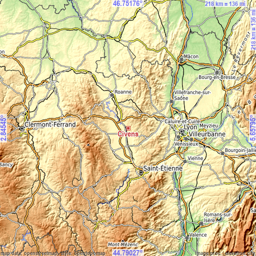
| \ | Map #1 | Topo.Map |
| Scale [m] | 320..607 m | × |
| Scale [ft] | 1050..1991 ft | × |
| Average | 394.7 m = 1295 ft | × |
| Width | 6.82 km = 4.2 mi | 218.1 km = 135.5 mi |
| Height | 6.82 km = 4.2 mi | 218.1 km = 135.5 mi |
| ↑Max Latitude | 45.81028° | 46.75176° |
| Latitude at center | 45.77964° | 45.77964° |
| ↓Min Latitude | 45.748983° | 44.79027° |
| ← Min Longitude | 4.207755° | 2.84545° |
| Longitude center | 4.2517° | 4.2517° |
| →Max Longitude | 4.295645° | 5.65795° |
Nearby cities:
Cities around Civens sort by population:
• Feurs elevation 350 m
5.5 km,  200°
200°
• Montrond-les-Bains 357 m
15.2 km,  184°
184°
• Panissières 606 m
7.1 km,  78°
78°
• Balbigny 345 m
6.5 km,  312°
312°
• Saint-Just-la-Pendue 561 m
12.8 km,  356°
356°
• Violay 879 m
11.7 km,  45°
45°
• Rozier-en-Donzy 501 m
3.1 km,  40°
40°
• Bussières 665 m
6.4 km,  13°
13°
• Haute-Rivoire 595 m
13.3 km,  122°
122°
• Saint-André-le-Puy 367 m
14.7 km, 177°
• Neulise 545 m
14.3 km,  337°
337°
• Pouilly-lès-Feurs 370 m
2.5 km,  323°
323°
Multilingual:
 En español:
Civens elevación 383 m.
 En France:
Civens élévation 383 m.


Sources and notes:
- [note 1] Map square and city borders are not equal. Map elevation data is calculated only from area inside that square.
- [src 1] Elevation data from geonames database provided with same terms of usage.
- [src 2] The elevation map of Civens is generated using elevation data from NASA's 3 arcsec (90m) resolution SRTM data.
- [src 3] Base (background) map © OpenStreetMap contributors tiles are generated by Geofabrik and OpenTopoMap.
Copyright & License:
This Civens Elevation Map is licensed under CC BY-SA. You may reuse any part from this page, if you give a proper credit by linking to this URL:
 More info on terms of use page.