Cahors elevation
Cahors (Occitanie, Lot), France elevation is 142 meters and Cahors elevation in feet is 466 ft above sea level [src 1]. Cahors is a seat of a second-order administrative division (feature code) with elevation that is 32 meters (105 ft) smaller than average city elevation in France.
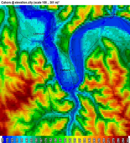
Below is the Elevation map of Cahors, which displays elevation range with different colors. Scale of the first map is from 108 to 301 m (354 to 988 ft) with average elevation of 191.3 meters (=628 ft) [note 1]
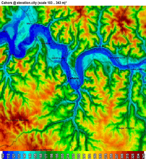
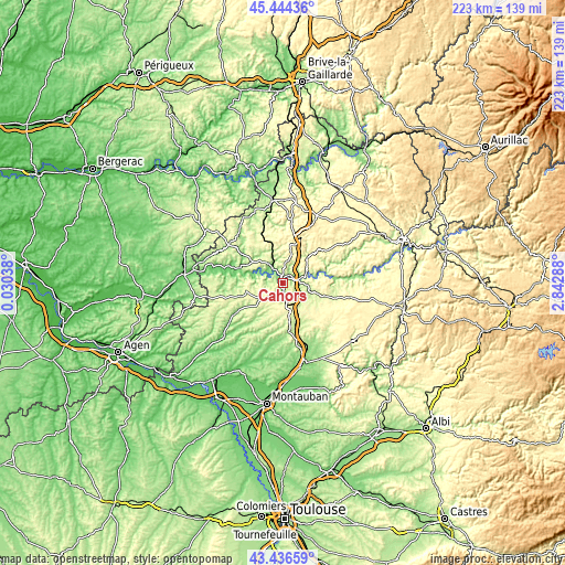
These maps also provides idea of topography and contour of this city, they are displayed at different zoom levels. More info about maps, scale and edge coordinates you can find below images.
| \ | Map #1 | Map #2 | Topo.Map |
| Scale [m] | 108..301 m | 103..343 m | × |
| Scale [ft] | 354..988 ft | 338..1125 ft | × |
| Average | 191.3 m = 628 ft | 213.2 m = 699 ft | × |
| Width | 6.98 km = 4.3 mi | 13.95 km = 8.7 mi | 223.2 km = 138.7 mi |
| Height | 6.98 km = 4.3 mi | 13.95 km = 8.7 mi | 223.2 km = 138.7 mi |
| ↑Max Latitude | 44.480463° | 44.511809° | 45.44436° |
| Latitude at center | 44.4491° | 44.4491° | 44.4491° |
| ↓Min Latitude | 44.41772° | 44.386324° | 43.43659° |
| ← Min Longitude | 1.392685° | 1.348739° | 0.03038° |
| Longitude center | 1.43663° | 1.43663° | 1.43663° |
| →Max Longitude | 1.480575° | 1.524521° | 2.84288° |
Nearby cities:
Cities around Cahors sort by population:
• Pradines elevation 138 m
4.7 km,  323°
323°
• Prayssac 110 m
20.6 km,  287°
287°
• Puy-l’Évêque 131 m
24.3 km,  284°
284°
• Castelnau-Montratier 194 m
21 km,  195°
195°
• Luzech 108 m
12.3 km, 285°
• Lauzerte 184 m
32 km,  227°
227°
• Montpezat-de-Quercy 264 m
23.6 km,  172°
172°
• Montcuq 208 m
21.9 km,  235°
235°
• Cazes-Mondenard 150 m
30.9 km,  216°
216°
• Salviac 167 m
29.1 km,  332°
332°
• Lalbenque 277 m
14.9 km,  144°
144°
• Molières 175 m
29.1 km,  191°
191°
Multilingual:
 En español:
Cahors elevación 142 m.
 En France:
Cahors élévation 142 m.


Sources and notes:
- [note 1] Map square and city borders are not equal. Map elevation data is calculated only from area inside that square.
- [src 1] Elevation data from geonames database provided with same terms of usage.
- [src 2] The elevation map of Cahors is generated using elevation data from NASA's 3 arcsec (90m) resolution SRTM data.
- [src 3] Base (background) map © OpenStreetMap contributors tiles are generated by Geofabrik and OpenTopoMap.
Copyright & License:
This Cahors Elevation Map is licensed under CC BY-SA. You may reuse any part from this page, if you give a proper credit by linking to this URL:
 More info on terms of use page.