Salviac elevation
Salviac (Occitanie, Lot), France elevation is 167 meters and Salviac elevation in feet is 548 ft above sea level [src 1]. Salviac is a populated place (feature code) with elevation that is 7 meters (23 ft) smaller than average city elevation in France.
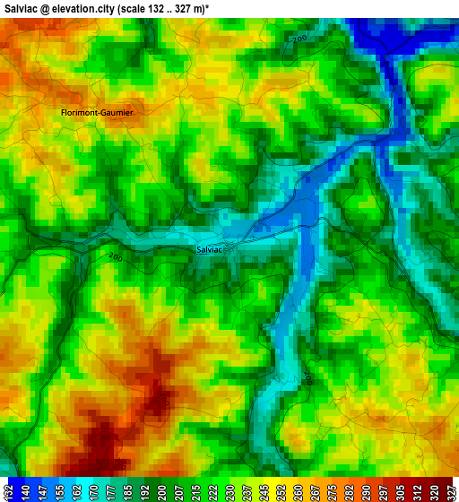
Below is the Elevation map of Salviac, which displays elevation range with different colors. Scale of the first map is from 132 to 327 m (433 to 1073 ft) with average elevation of 222.8 meters (=731 ft) [note 1]
These maps also provides idea of topography and contour of this city, they are displayed at different zoom levels. More info about maps, scale and edge coordinates you can find below images.
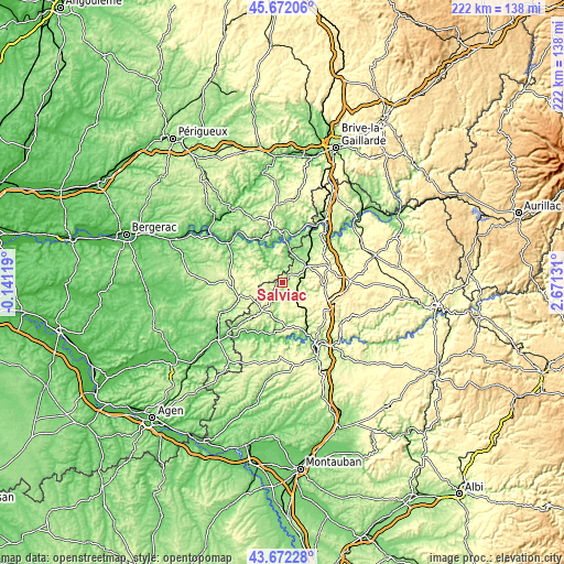
| \ | Map #1 | Topo.Map |
| Scale [m] | 132..327 m | × |
| Scale [ft] | 433..1073 ft | × |
| Average | 222.8 m = 731 ft | × |
| Width | 6.95 km = 4.3 mi | 222.4 km = 138.2 mi |
| Height | 6.95 km = 4.3 mi | 222.3 km = 138.1 mi |
| ↑Max Latitude | 44.712038° | 45.67206° |
| Latitude at center | 44.6808° | 44.6808° |
| ↓Min Latitude | 44.649545° | 43.67228° |
| ← Min Longitude | 1.221115° | -0.14119° |
| Longitude center | 1.26506° | 1.26506° |
| →Max Longitude | 1.309005° | 2.67131° |
Nearby cities:
Cities around Salviac sort by population:
• Sarlat-la-Canéda elevation 147 m
23.5 km,  350°
350°
• Gourdon 221 m
11.2 km,  55°
55°
• Pradines 138 m
24.4 km,  153°
153°
• Prayssac 110 m
20.5 km,  197°
197°
• Puy-l’Évêque 131 m
21.9 km,  206°
206°
• Luzech 108 m
22.6 km,  175°
175°
• Saint-Cyprien 69 m
27.4 km,  319°
319°
• Belvès 174 m
23.1 km,  297°
297°
• Carsac-Aillac 104 m
17 km,  355°
355°
• Le Vigan 237 m
15.3 km, 64°
• Cénac-et-Saint-Julien 89 m
14 km,  340°
340°
• Domme 211 m
14.1 km, 343°
Multilingual:
 En español:
Salviac elevación 167 m.
 En France:
Salviac élévation 167 m.


Sources and notes:
- [note 1] Map square and city borders are not equal. Map elevation data is calculated only from area inside that square.
- [src 1] Elevation data from geonames database provided with same terms of usage.
- [src 2] The elevation map of Salviac is generated using elevation data from NASA's 3 arcsec (90m) resolution SRTM data.
- [src 3] Base (background) map © OpenStreetMap contributors tiles are generated by Geofabrik and OpenTopoMap.
Copyright & License:
This Salviac Elevation Map is licensed under CC BY-SA. You may reuse any part from this page, if you give a proper credit by linking to this URL:
 More info on terms of use page.