Gourdon elevation
Gourdon (Occitanie, Lot), France elevation is 221 meters and Gourdon elevation in feet is 725 ft above sea level [src 1]. Gourdon is a seat of a third-order administrative division (feature code) with elevation that is 47 meters (154 ft) bigger than average city elevation in France.
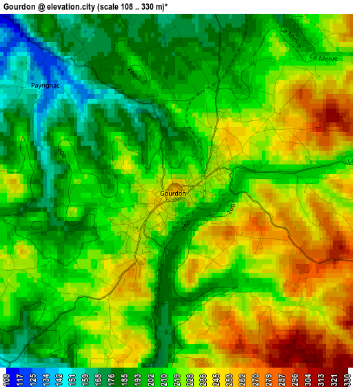
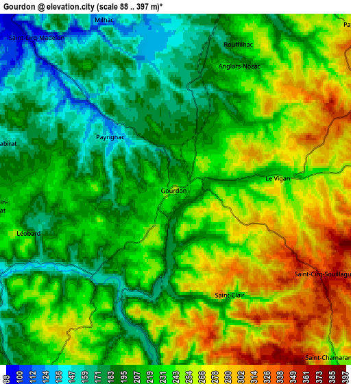
Below is the Elevation map of Gourdon, which displays elevation range with different colors. Scale of the first map is from 108 to 330 m (354 to 1083 ft) with average elevation of 215.8 meters (=708 ft) [note 1]
These maps also provides idea of topography and contour of this city, they are displayed at different zoom levels. More info about maps, scale and edge coordinates you can find below images.
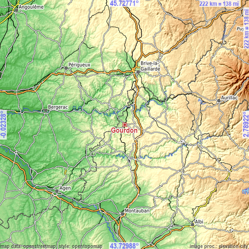
| \ | Map #1 | Map #2 | Topo.Map |
| Scale [m] | 108..330 m | 88..397 m | × |
| Scale [ft] | 354..1083 ft | 289..1302 ft | × |
| Average | 215.8 m = 708 ft | 225.8 m = 741 ft | × |
| Width | 6.94 km = 4.3 mi | 13.88 km = 8.6 mi | 222.1 km = 138 mi |
| Height | 6.94 km = 4.3 mi | 13.88 km = 8.6 mi | 222.1 km = 138 mi |
| ↑Max Latitude | 44.768628° | 44.799819° | 45.72771° |
| Latitude at center | 44.73742° | 44.73742° | 44.73742° |
| ↓Min Latitude | 44.706195° | 44.674954° | 43.72988° |
| ← Min Longitude | 1.339025° | 1.295079° | -0.02328° |
| Longitude center | 1.38297° | 1.38297° | 1.38297° |
| →Max Longitude | 1.426915° | 1.470861° | 2.78922° |
Nearby cities:
Cities around Gourdon sort by population:
• Sarlat-la-Canéda elevation 147 m
21.4 km,  322°
322°
• Souillac 118 m
19.1 km,  21°
21°
• Gramat 310 m
27 km,  79°
79°
• Pradines 138 m
28.3 km,  177°
177°
• Martel 238 m
28.4 km,  38°
38°
• Carsac-Aillac 104 m
15 km, 315°
• Le Vigan 237 m
4.5 km,  85°
85°
• Eyvigues-et-Eybènes 269 m
21.9 km,  353°
353°
• Salviac 167 m
11.2 km,  235°
235°
• Salignac-Eyvigues 290 m
26.8 km, 350°
• Cénac-et-Saint-Julien 89 m
15.6 km,  296°
296°
• Domme 211 m
15.1 km, 298°
Multilingual:
 En español:
Gourdon elevación 221 m.
 En France:
Gourdon élévation 221 m.


Sources and notes:
- [note 1] Map square and city borders are not equal. Map elevation data is calculated only from area inside that square.
- [src 1] Elevation data from geonames database provided with same terms of usage.
- [src 2] The elevation map of Gourdon is generated using elevation data from NASA's 3 arcsec (90m) resolution SRTM data.
- [src 3] Base (background) map © OpenStreetMap contributors tiles are generated by Geofabrik and OpenTopoMap.
Copyright & License:
This Gourdon Elevation Map is licensed under CC BY-SA. You may reuse any part from this page, if you give a proper credit by linking to this URL:
 More info on terms of use page.