Cambrai elevation
Cambrai (Hauts-de-France, Nord), France elevation is 66 meters and Cambrai elevation in feet is 217 ft above sea level [src 1]. Cambrai is a seat of a third-order administrative division (feature code) with elevation that is 108 meters (354 ft) smaller than average city elevation in France.
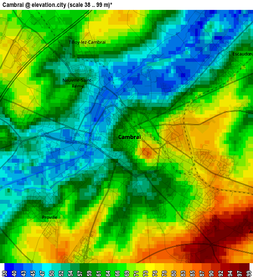
Below is the Elevation map of Cambrai, which displays elevation range with different colors. Scale of the first map is from 38 to 99 m (125 to 325 ft) with average elevation of 63.6 meters (=209 ft) [note 1]
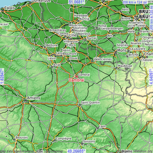
These maps also provides idea of topography and contour of this city, they are displayed at different zoom levels. More info about maps, scale and edge coordinates you can find below images.
| \ | Map #1 | Map #2 | Topo.Map |
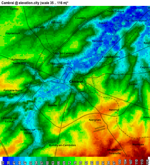
| Scale [m] | 38..99 m | 35..116 m | × |
| Scale [ft] | 125..325 ft | 115..381 ft | × |
| Average | 63.6 m = 209 ft | 67.6 m = 222 ft | × |
| Width | 6.26 km = 3.9 mi | 12.52 km = 7.8 mi | 200.3 km = 124.5 mi |
| Height | 6.26 km = 3.9 mi | 12.52 km = 7.8 mi | 200.3 km = 124.5 mi |
| ↑Max Latitude | 50.204096° | 50.232215° | 51.0681° |
| Latitude at center | 50.17596° | 50.17596° | 50.17596° |
| ↓Min Latitude | 50.147808° | 50.119639° | 49.26685° |
| ← Min Longitude | 3.190775° | 3.146829° | 1.82847° |
| Longitude center | 3.23472° | 3.23472° | 3.23472° |
| →Max Longitude | 3.278665° | 3.322611° | 4.64097° |
Nearby cities:
Cities around Cambrai sort by population:
• Neuville-Saint-Rémy elevation 46 m
1.4 km,  326°
326°
• Proville 52 m
2.6 km,  231°
231°
• Escaudœuvres 50 m
3.5 km,  40°
40°
• Iwuy 48 m
8.8 km, 43°
• Masnières 69 m
7 km,  195°
195°
• Raillencourt-Sainte-Olle 70 m
4.9 km,  279°
279°
• Marcoing 56 m
7.5 km,  215°
215°
• Féchain 44 m
10.2 km,  350°
350°
• Fontaine-Notre-Dame 71 m
5.5 km,  259°
259°
• Rumilly-en-Cambrésis 84 m
5.6 km,  191°
191°
• Rieux-en-Cambrésis 54 m
8.8 km,  71°
71°
• Bourlon 80 m
8.6 km,  270°
270°
Multilingual:
 En español:
Cambrai elevación 66 m.
 En France:
Cambrai élévation 66 m.


Sources and notes:
- [note 1] Map square and city borders are not equal. Map elevation data is calculated only from area inside that square.
- [src 1] Elevation data from geonames database provided with same terms of usage.
- [src 2] The elevation map of Cambrai is generated using elevation data from NASA's 3 arcsec (90m) resolution SRTM data.
- [src 3] Base (background) map © OpenStreetMap contributors tiles are generated by Geofabrik and OpenTopoMap.
Copyright & License:
This Cambrai Elevation Map is licensed under CC BY-SA. You may reuse any part from this page, if you give a proper credit by linking to this URL:
 More info on terms of use page.