Cap-d’Ail elevation
Cap-d’Ail (Provence-Alpes-Côte d'Azur, Alpes-Maritimes), France elevation is 22 meters and Cap-d’Ail elevation in feet is 72 ft above sea level [src 1]. Cap-d’Ail is a populated place (feature code) with elevation that is 152 meters (499 ft) smaller than average city elevation in France.
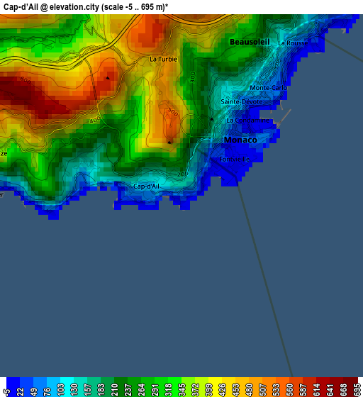
Below is the Elevation map of Cap-d’Ail, which displays elevation range with different colors. Scale of the first map is from -5 to 695 m (-16 to 2280 ft) with average elevation of 293.2 meters (=962 ft) [note 1]
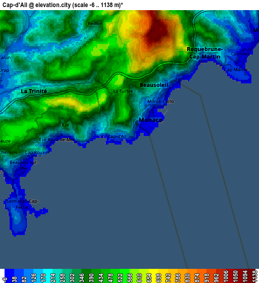
These maps also provides idea of topography and contour of this city, they are displayed at different zoom levels. More info about maps, scale and edge coordinates you can find below images.
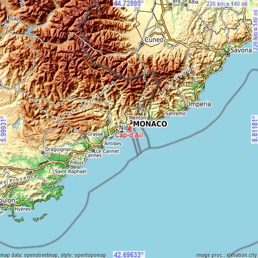
| \ | Map #1 | Map #2 | Topo.Map |
| Scale [m] | -5..695 m | -6..1138 m | × |
| Scale [ft] | -16..2280 ft | -20..3734 ft | × |
| Average | 293.2 m = 962 ft | 337.1 m = 1106 ft | × |
| Width | 7.06 km = 4.4 mi | 14.13 km = 8.8 mi | 226 km = 140.4 mi |
| Height | 7.06 km = 4.4 mi | 14.13 km = 8.8 mi | 226 km = 140.4 mi |
| ↑Max Latitude | 43.753011° | 43.784746° | 44.72895° |
| Latitude at center | 43.72126° | 43.72126° | 43.72126° |
| ↓Min Latitude | 43.689492° | 43.657707° | 42.69633° |
| ← Min Longitude | 7.361615° | 7.317669° | 5.99931° |
| Longitude center | 7.40556° | 7.40556° | 7.40556° |
| →Max Longitude | 7.449505° | 7.493451° | 8.81181° |
Nearby cities:
Cities around Cap-d’Ail sort by population:
• Beausoleil elevation 72 m
2.8 km,  29°
29°
• Roquebrune-Cap-Martin 19 m
7.8 km,  52°
52°
• La Trinité 175 m
7.7 km,  286°
286°
• Villefranche-sur-Mer 37 m
7.8 km,  255°
255°
• Drap 183 m
7.7 km,  299°
299°
• Beaulieu-sur-Mer 1 m
6.2 km, 255°
• La Turbie 487 m
2.7 km,  351°
351°
• Èze 348 m
3.6 km,  282°
282°
• Saint-Jean-Cap-Ferrat 18 m
6.8 km,  237°
237°
• Cantaron 224 m
8.4 km, 302°
• Peillon 369 m
6.6 km,  343°
343°
• Gorbio 369 m
7.9 km,  22°
22°
Multilingual:
 En español:
Cap-d’Ail elevación 22 m.
 En France:
Cap-d'Ail élévation 22 m.
 Auf Deutsch:
Cap-d’Ail höhe über dem Meeresspiegel ist 22 m.

Sources and notes:
- [note 1] Map square and city borders are not equal. Map elevation data is calculated only from area inside that square.
- [src 1] Elevation data from geonames database provided with same terms of usage.
- [src 2] The elevation map of Cap-d’Ail is generated using elevation data from NASA's 3 arcsec (90m) resolution SRTM data.
- [src 3] Base (background) map © OpenStreetMap contributors tiles are generated by Geofabrik and OpenTopoMap.
Copyright & License:
This Cap-d’Ail Elevation Map is licensed under CC BY-SA. You may reuse any part from this page, if you give a proper credit by linking to this URL:
 More info on terms of use page.