Drap elevation
Drap (Provence-Alpes-Côte d'Azur, Alpes-Maritimes), France elevation is 183 meters and Drap elevation in feet is 600 ft above sea level [src 1]. Drap is a populated place (feature code) with elevation that is 9 meters (30 ft) bigger than average city elevation in France.
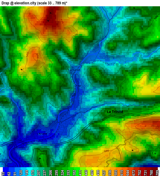
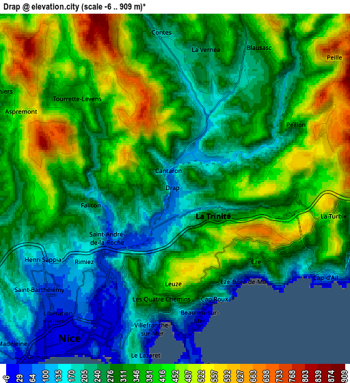
Below is the Elevation map of Drap, which displays elevation range with different colors. Scale of the first map is from 33 to 789 m (108 to 2589 ft) with average elevation of 296.6 meters (=973 ft) [note 1]
These maps also provides idea of topography and contour of this city, they are displayed at different zoom levels. More info about maps, scale and edge coordinates you can find below images.
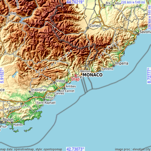
| \ | Map #1 | Map #2 | Topo.Map |
| Scale [m] | 33..789 m | -6..909 m | × |
| Scale [ft] | 108..2589 ft | -20..2982 ft | × |
| Average | 296.6 m = 973 ft | 332.7 m = 1092 ft | × |
| Width | 7.06 km = 4.4 mi | 14.12 km = 8.8 mi | 225.9 km = 140.4 mi |
| Height | 7.06 km = 4.4 mi | 14.12 km = 8.8 mi | 225.9 km = 140.4 mi |
| ↑Max Latitude | 43.786813° | 43.81853° | 44.76219° |
| Latitude at center | 43.75508° | 43.75508° | 43.75508° |
| ↓Min Latitude | 43.72333° | 43.691563° | 42.73073° |
| ← Min Longitude | 7.277575° | 7.233629° | 5.91527° |
| Longitude center | 7.32152° | 7.32152° | 7.32152° |
| →Max Longitude | 7.365465° | 7.409411° | 8.72777° |
Nearby cities:
Cities around Drap sort by population:
• La Trinité elevation 175 m
1.7 km,  200°
200°
• Villefranche-sur-Mer 37 m
5.8 km,  188°
188°
• Contes 256 m
6.4 km,  354°
354°
• Saint-André-de-la-Roche 97 m
3.9 km,  231°
231°
• Tourrette-Levens 450 m
5 km,  313°
313°
• Beaulieu-sur-Mer 1 m
5.4 km,  171°
171°
• La Turbie 487 m
6.4 km,  99°
99°
• Èze 348 m
4.4 km,  132°
132°
• Falicon 100 m
3.5 km,  258°
258°
• Cantaron 224 m
0.8 km,  337°
337°
• Blausasc 319 m
6.6 km,  31°
31°
• Peillon 369 m
5.6 km,  61°
61°
Multilingual:
 En español:
Drap elevación 183 m.
 En France:
Drap élévation 183 m.


Sources and notes:
- [note 1] Map square and city borders are not equal. Map elevation data is calculated only from area inside that square.
- [src 1] Elevation data from geonames database provided with same terms of usage.
- [src 2] The elevation map of Drap is generated using elevation data from NASA's 3 arcsec (90m) resolution SRTM data.
- [src 3] Base (background) map © OpenStreetMap contributors tiles are generated by Geofabrik and OpenTopoMap.
Copyright & License:
This Drap Elevation Map is licensed under CC BY-SA. You may reuse any part from this page, if you give a proper credit by linking to this URL:
 More info on terms of use page.