Caraman elevation
Caraman (Occitanie, Haute-Garonne), France elevation is 250 meters and Caraman elevation in feet is 820 ft above sea level [src 1]. Caraman is a populated place (feature code) with elevation that is 76 meters (249 ft) bigger than average city elevation in France.
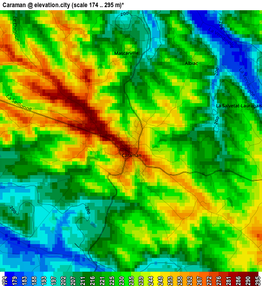
Below is the Elevation map of Caraman, which displays elevation range with different colors. Scale of the first map is from 174 to 295 m (571 to 968 ft) with average elevation of 226.9 meters (=744 ft) [note 1]
These maps also provides idea of topography and contour of this city, they are displayed at different zoom levels. More info about maps, scale and edge coordinates you can find below images.
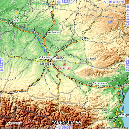
| \ | Map #1 | Topo.Map |
| Scale [m] | 174..295 m | × |
| Scale [ft] | 571..968 ft | × |
| Average | 226.9 m = 744 ft | × |
| Width | 7.08 km = 4.4 mi | 226.7 km = 140.9 mi |
| Height | 7.08 km = 4.4 mi | 226.7 km = 140.9 mi |
| ↑Max Latitude | 43.564561° | 44.54359° |
| Latitude at center | 43.53271° | 43.53271° |
| ↓Min Latitude | 43.500842° | 42.50459° |
| ← Min Longitude | 1.716075° | 0.35377° |
| Longitude center | 1.76002° | 1.76002° |
| →Max Longitude | 1.803965° | 3.16627° |
Nearby cities:
Cities around Caraman sort by population:
• Villefranche-de-Lauragais elevation 182 m
15.2 km,  193°
193°
• Drémil-Lafage 198 m
14.6 km,  298°
298°
• Verfeil 229 m
15.9 km,  330°
330°
• Baziège 162 m
14.6 km,  233°
233°
• Auzielle 200 m
15.7 km,  273°
273°
• Saint-Félix-Lauragais 334 m
13.9 km,  132°
132°
• Lanta 208 m
8.4 km, 296°
• Belberaud 178 m
15.8 km,  259°
259°
• Auriac-sur-Vendinelle 193 m
5.4 km,  100°
100°
• Villenouvelle 175 m
13.3 km,  216°
216°
• Labastide-Beauvoir 263 m
9.5 km, 233°
• Montlaur 161 m
16.2 km,  252°
252°
Multilingual:
 En español:
Caraman elevación 250 m.
 En France:
Caraman élévation 250 m.


Sources and notes:
- [note 1] Map square and city borders are not equal. Map elevation data is calculated only from area inside that square.
- [src 1] Elevation data from geonames database provided with same terms of usage.
- [src 2] The elevation map of Caraman is generated using elevation data from NASA's 3 arcsec (90m) resolution SRTM data.
- [src 3] Base (background) map © OpenStreetMap contributors tiles are generated by Geofabrik and OpenTopoMap.
Copyright & License:
This Caraman Elevation Map is licensed under CC BY-SA. You may reuse any part from this page, if you give a proper credit by linking to this URL:
 More info on terms of use page.